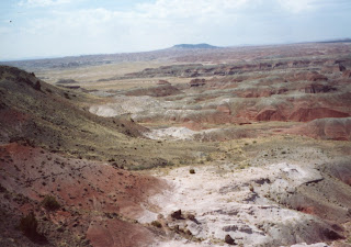
Hike Location: Painted Desert, Petrified Forest National Park
Geographic Location: east of Holbrook, AZ (35.08009, -109.78360)
Length: 1.3 miles
Difficulty: 1/10 (Easy)
Date Hiked: May 2006
Overview: A flat trail with great views of the Painted Desert.
Park Information: http://www.nps.gov/pefo/
Directions to the trailhead: In northern Arizona, take I-40 to Petrified Forest National Park (exit 311). Exit and go north to enter the park, paying the park entrance fee. Follow the park road for nearly 2 miles to the signed parking area for Tawa Point. Park in this parking lot.
The hike: Though Badlands rock formations occur at various points throughout the world, few are as colorful as those found in the desert of northeast Arizona. For this reason, this section of land is often referred to as the Painted Desert. Now the northern part of Petrified Forest National Park Painted Desert .
Though the basin of the Painted Desert itself is protected as a wilderness area, marvelous views can be had from the rim, which is traversed by a 6 mile road (north of I-40) and this short hiking trail. The road offers 9 designated overlooks (called “points), each of which gives a slightly different view of the Painted Desert. All of these points are worth a stop. This trail, the Rim Trail, connects two of these overlooks, Tawa Point and Kachina Point. While you could simply drive to the point on each end, the trail offers a first-hand experience of the rim environment and provides an extended opportunity to view the colors of the Painted Desert.
From the parking lot for Tawa Point, walk down the blacktop path to the overlook itself and take a few minutes to observe the colorful horizontal bands that form the Painted Desert. Each band represents a different kind of rock. At the top is a dull white band, a very hard layer of sandstone. Below the sandstone lies several bands of red-orange-yellow rocks, soft, crumbly rock that is easily eroded by water. These bands are called claystone, and the colors are determined by the minerals found in the rock. For example, the red bands have high concentrations of iron oxide. Deep, steep gullies appear as tiny ditches from this point and show you where water runs off. The desert basin itself is a dry, dusty yellow dotted with desert plants.
 |
| View into desert from Tawa Point |
 |
| View down rim toward Kachina Point |
 |
| View north into wilderness area from Kachina Point |
No comments:
Post a Comment