Showing posts with label Wisconsin Hikes. Show all posts

Sunday, November 17, 2024

Aztalan State Park (Blog Hike #1025)

Trails: (unnamed)
Hike Location: Aztalan State Park (43.06341, -88.86238)
Geographic Location: west of Johnson Creek, WI
Length: 1.4 miles
Difficulty: 2/10 (Easy)
Date Hiked: September 2024
Overview: A loop hike around a village dating to 1000-1300 AD.
Park Information: https://dnr.wisconsin.gov/topic/parks/aztalan
Hike Route Map: https://www.mappedometer.com/?maproute=972445
Photo Highlight:
Hike Video: (coming April 24, 2026)

Directions to the trailhead: Between Madison and Milwaukee, take I-94 to SR 26 (exit 267).  Exit and go south on SR 26.  Drive SR 26 south 0.8 miles to Milwaukee Street and turn right on Milwaukee St.  Milwaukee St. becomes Aztalan Street and then CR B as you drive west out of Johnson Creek.  Drive a total of 4.9 miles from SR 26 to CR Q and turn left on CR Q.  Drive CR Q south 0.3 miles to the signed park entrance on the left.  Turn left to enter the park and drive the main park road to the large parking lot at its end.  Park here.

The hike: When most people think of the ancient Middle Mississippian Mound Builders, they think of their amazing center they built at Cahokia Mounds across the Mississippi River from present-day St. Louis.  Yet the Mound Builders' civilization extended north through most of present-day Wisconsin, and around 900 A.D they settled along the Crawfish River in the southern part of the state.  Over the next 300 years the Middle Mississippian people built some of the largest pyramid/platform mounds in present-day Wisconsin, and they also built a stockade near the mounds by placing logs vertically into the ground.
            The site was abandoned between 1200 and 1300 A.D., possibly due to a mini ice age making food sourcing in Wisconsin difficult.  The ruins were discovered by Timothy Johnson in 1835, yet the land was still sold and farmed afterward.  The mounds and stockades that had stood the test of time for hundreds of years did not fare as well against the plow: the mounds were flattened and the stockades destroyed.
            In 1921, the Wisconsin Archaeological Society purchased a 3 acre plot of land that adjoined what remained of the stockade and contained 8 conical mounds.  In 1948, the Wisconsin State Legislature authorized the purchase of 120 acres that would constitute the main part of the site, and Aztalan State Park opened in 1952.  Today the mounds and stockade have been restored, and a system of hiking trails takes you through the site.  This hike forms a grand loop past all of the mounds and stockades, thus offering a thorough exploration of the ancient site.
Leaving the parking area
    
        Three mowed-grass trails leave from the main parking lot; you want to take the one in the middle that heads northeast to the "southeast mound," which is also known as the Gravel Knoll.  In fact, this "mound" is not a constructed mound but a naturally occurring kame deposited by retreating glaciers.  The kame still makes an interesting stop on your mound tour even though it represents natural history rather than human history.
Stairs to top of Southwest Mound
    
        To get from the kame to a real mound, turn left and head due west to the Southwest Mound, a 2-tier platform/pyramid mound.  Constructed wooden stairs lead to the top of the mound.  
You can survey the entire site from the top of the Southwest Mound, which is this site's biggest mound.  Archaeologists think this mound had a large structure on its summit, and it was probably used for communal and ritual activities.  No evidence of burials have been found in this mound.  Also, notice the reconstructed stockade to the west; it is one of 2 such stockades in the park today.
View of Gravel Knoll from Southwest Mound
View of plaza to the north from Southwest Mound
    
        After taking in the view, descend to the base of the mound and head north following another mowed-grass trail that goes through the sunny prairie.  At 0.4 miles, you reach the Northwest Mound.  This mound is another platform mound.  Although it is smaller than the Southwest Mound, archaeological evidence indicates numerous burials in this mound compared to none at the previous mound.  There are no stairs or trails leading to the top of the Northwest Mound, and I do not recommend that you climb it.
Northwest Mound
    
        To continue your tour of the site, turn left and climb slightly to approach a secondary parking area that is very close to CR Q.  Before reaching the parking lot, turn right to begin hiking north along a row of conical mounds.  Archaeologists think these mounds were built to commemorate important events, and the row used to extend much further north than it does today.
Conical mound
    
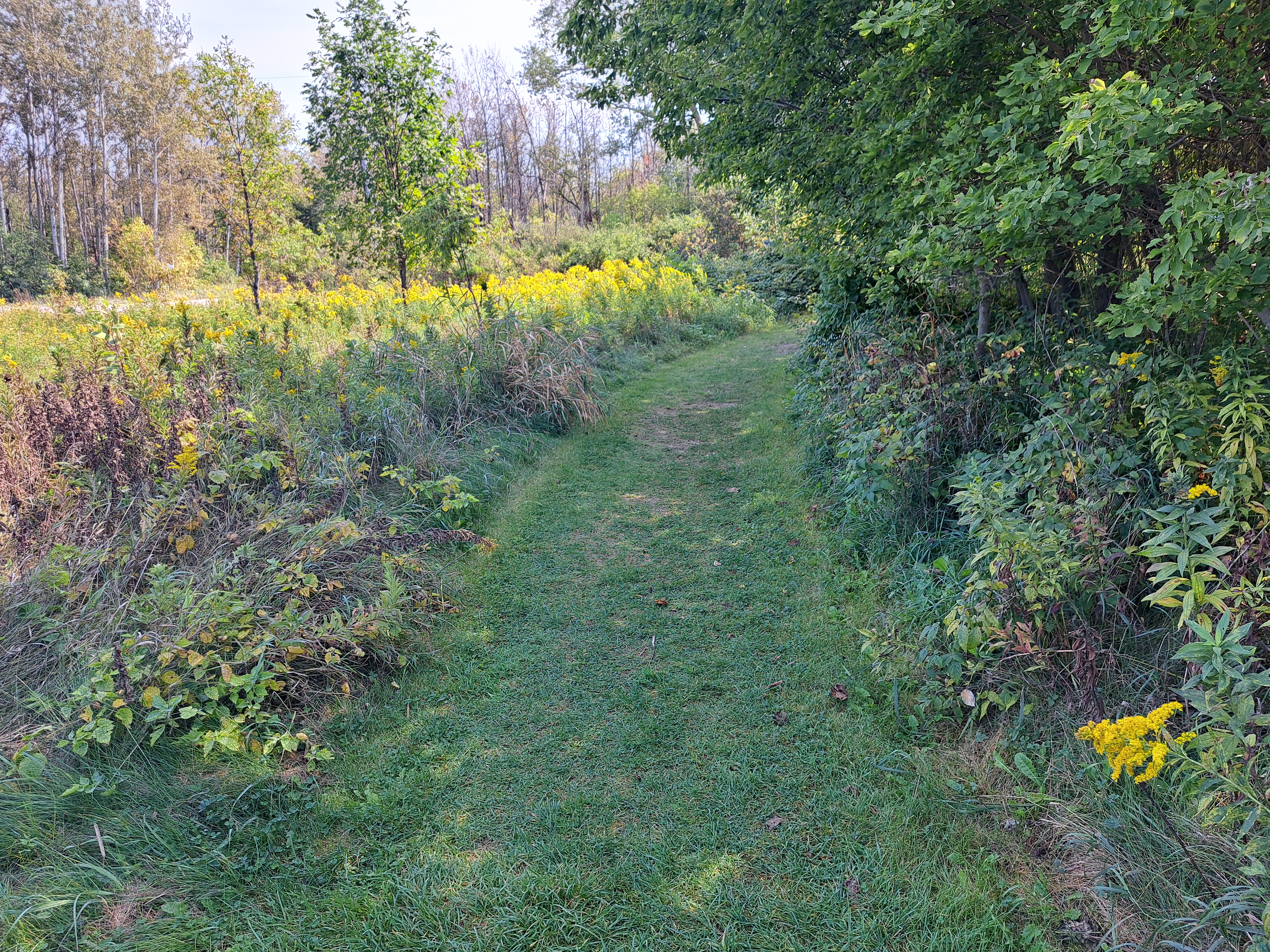
        At 0.65 miles, you reach the park's north boundary and the highest elevation on this hike, which is about 70 vertical feet above the trailhead.  To begin your return route, turn right and descend steeply for a short distance along the north perimeter of the prairie.  Goldenrod was in full bloom in this prairie when I came here on a warm evening in mid-September, and the return route focuses more on this site's natural scenery than on its human history.
Crawfish River
    
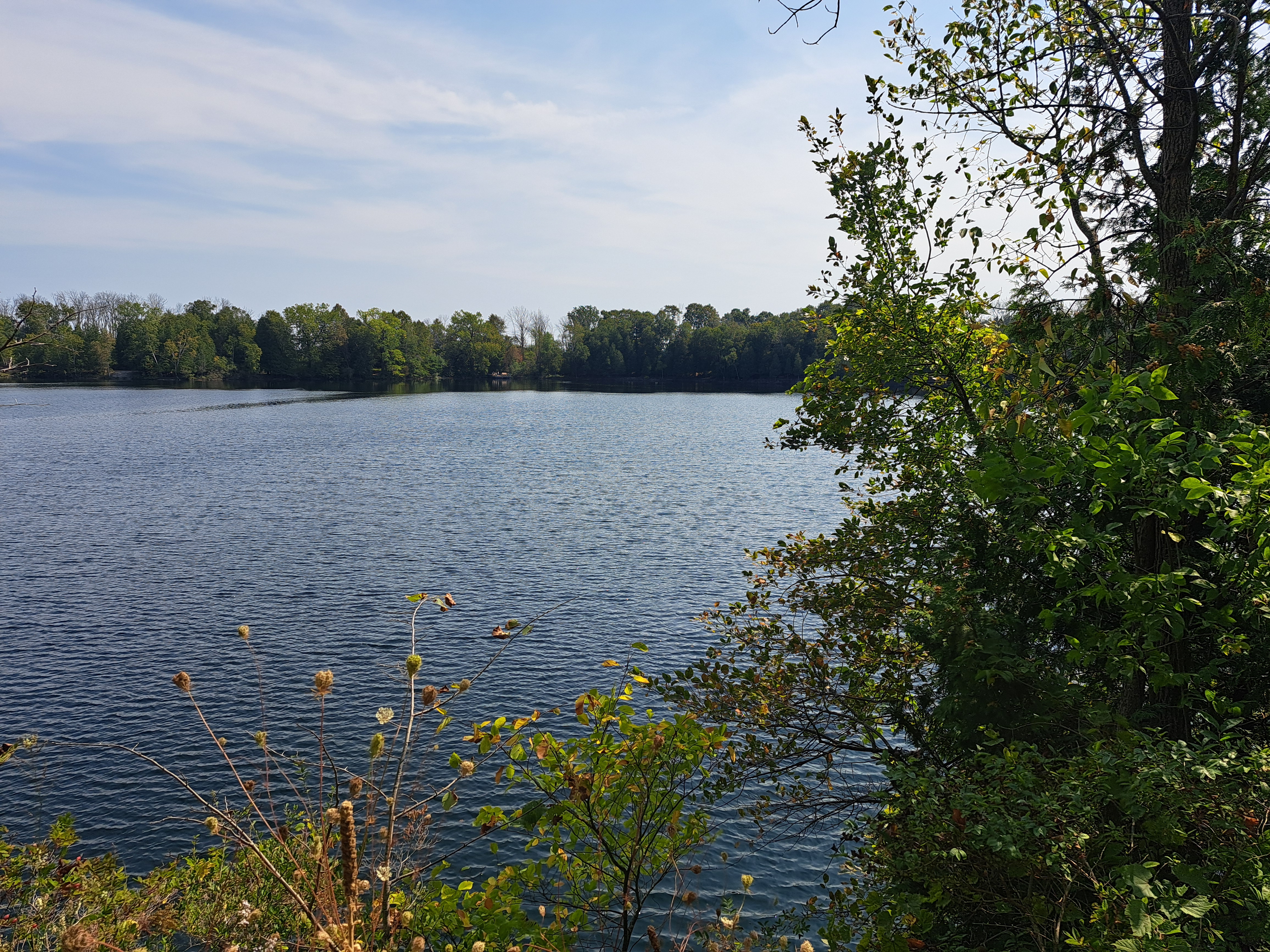
        When you reach the exterior of the stockade, turn left to head for the Crawfish River, which you reach 1 mile into the hike.  The river was this site's original main entrance road, and down here you view the site the way ancient peoples would have approached it.  Turn right to begin hiking downstream with the river on your left.  Angle left when you reach the Gravel Knoll for a second time, and a short descent and climb returns you to the parking area to complete the hike.

Tuesday, November 12, 2024

Lizard Mound State Park (Blog Hike #1024)

Trails: (unnamed)
Hike Location: Lizard Mound State Park
Geographic Location: northeast of West Bend, WI (43.46402, -88.14055)
Length: 1.1 miles
Difficulty: 1/10 (Easy)
Date Hiked: September 2024
Overview: A short, flat loop past many effigy mounds including the famous Lizard Mound.
Park Information: https://dnr.wisconsin.gov/topic/parks/lizardmound
Hike Route Map: https://www.mappedometer.com/?maproute=972355
Photo Highlight:
Short Video:

Directions to the trailhead: From West Bend, take SR 144 north 3.7 miles to CR A.  Turn right on CR A.  The park entrance is 0.4 miles ahead on the right.  Turn right to enter the park, and park in the only parking lot.

The hike: Hundreds of years before the first European explorers arrived in America, the Mound Builder peoples lived a nomadic hunter-gatherer lifestyle across what is now the eastern United States.  The Mound Builders lived in societies that were highly organized for their era, and they built their characteristic mounds at numerous sites, many of which are protected today as state or national parks.  Wisconsin lies on the northern end of the Mound Builders' geographical range, and the Lizard Mound site is one of the best places in Wisconsin to view the Mound Builders' legacy.
            The historical value of the Lizard Mound site lies not so much in the size of the mounds as in their variety and quantity: at least 60 mounds of various shapes have been identified at this site.  The exact date and builders of the mounds remain unknown, but most experts think they were constructed between 650 and 1300 AD.  Some of the mounds were destroyed by farming before Washington County established the site as a county park in 1950: only 47 of the original 60+ mounds remain today.  The State of Wisconsin acquired the site in 1986, and it was added to the National Register of Historic Places in 1996.
            True to a park established to preserve history, tiny 22-acre Lizard Mound State Park has limited amenities.  The park offers only a parking lot, some picnic tables, and a small interpretive center that gives you information about the mounds.  A limited system of unnamed and unmarked trails provides access to the mounds, and the hike described here takes you on a winding route designed to maximize your distance and your mound viewing.
Interpretive center
    
        Start by heading to the interpretive center.  To get there from the main parking lot, walk back out the park entrance road and angle left to reach the small picnic shelter-looking building.  Although many questions about these mounds remain unanswered, numerous signs give general information about effigy and burial mounds as well as specific information about this site.
Heading toward the mounds
    
        Armed with some knowledge about the mounds, next head for the mounds themselves by exiting the interpretive center to the south and walking between 2 ornamental metal fixtures that bear lizard-like shapes.  The first part of this hike goes through a sunny grassy area that is dotted with trees.  In general you want to turn right at each trail intersection to take the longest possible route through the mounds.
Passing a mound
    
        Quickly it becomes apparent that these mounds come in many shapes and sizes.  The first mound you pass on the left is a T-shaped mound that resembles a bird when viewed from above, while the next one is an elongated mound many experts think was meant to resemble a panther.  More ordinary conical and linear mounds are also passed.

Large panther mound
    
        At 0.3 miles, you pass a large panther mound that I originally thought was this site's signature lizard mound, but in fact the lizard mound sits just beyond and is signed.  This site has several panther, bird, conical, and linear mounds, but it only has 1 lizard mound.  You approach the lizard at its head, and the best vantage point looks over the lizard's front and back legs down its elongated tail.  A bench encourages you to sit, rest, and admire the unusually-shaped mound.
Lizard mound, looking toward the head
Lizard mound, looking toward the tail
    
        Past the lizard mound, the trail passes between a pair of panther mounds and enters a more heavily wooded area, where it will remain for the rest of the hike.  This area could be very buggy in the spring and summer, but bugs were not a problem when I hiked here in mid-September.  Many more conical and linear mounds are passed, and while no mound on this site is more than a couple feet high, all of them are interesting.
Conical mound in the woods
    
        The trail takes a serpentine course through the wooded eastern part of the park, and the persistently flat terrain might make you feel like you are hiking in circles.  Keep turning right at each trail intersection and keep following the trail.  Just shy of 1 mile, you reach an old hand water pump that probably dates to this land's agricultural days.  The main parking lot sits just to the right, thus signaling the end of the hike.

Saturday, November 9, 2024

Kohler-Andrae State Park: The Cordwalk (Blog Hike #1023)

Trail: The Cordwalk
Hike Location: Kohler-Andrae State Park
Geographic Location: south of Sheboygan, WI (43.66733, -87.71630)
Length: 3 miles
Difficulty: 5/10 (Moderate)
Date Hiked: September 2024
Overview: A double out-and-back atop sand dunes along Lake Michigan.
Park Information: https://dnr.wisconsin.gov/topic/parks/kohlerandrae
Hike Route Map: https://www.mappedometer.com/?maproute=972356
Photo Highlight:
Hike Video:

Directions to the trailhead: Just south of Sheboygan, take I-43 to CR V (exit 120).  Exit, go east, then quickly turn right to stay on CR V.  Where CR V ends in 1.9 miles, continue straight to enter the park.  Pay the entrance fee, then follow signs for the Sanderling Nature Center, where this hike begins.

The hike: Consisting of 988 acres on the shore of Lake Michigan, Kohler-Andrae State Park's hyphenated name stems from its 2 separate histories.  The park's southern 122 acres were originally known as Terry Andrae State Park, which was established in 1928.  Terry Andrae was the President of the Julius Andrae and Sons' Electric Supply Company in Milwaukee, and he built a second house on this property to take advantage of the scenic dunes overlooking Lake Michigan.  After Andrae died in 1927, his family donated the land to the State of Wisconsin to form the park that bore his name.
            In an unrelated event, in 1966 the Kohler Company donated 280 acres of land located immediately north of the existing park.  Rather than adding the land to Terry Andrae State Park as would be customary, the Kohler donation was formed into a new park called John Michael Kohler State Park to honor the company's founder.  Additional adjacent land acquisitions bring the area's size to the current total.  While the "park" is still officially 2 separate state parks, they are managed, maintained, and marketed as a single entity: Kohler-Andrae State Park.
            In 2023, the park was the 7th most visited state park in Wisconsin, and it offers some fantastic amenities including a 135-site developed campground, some picnic areas, and a nature center.  Yet the park's main attraction remains the same as it was in Andrae's day: the dunes overlooking Lake Michigan.  Several hiking trails explore the dunes, and this hike describes possibly the most famous trail in Wisconsin: the Kohler Cordwalk.  The Cordwalk features fantastic dune-top Lake Michigan scenery, but the Cordwalk's unusual construction makes the hiking much easier than walking in soft sand.  I came here on a warm sunny morning in mid-September, and I had a splendid, scenic, and memorable hike.
Trailhead for southern Cordwalk
    
        The Cordwalk can be accessed at 3 distinct points; I chose to start at the Sanderling Nature Center near the Cordwalk's midpoint because it is easy to find and has a large parking lot.  Pick up the Cordwalk as it heads southeast from the parking lot.  A large sign that says "Kohler Dunes State Natural Area" marks this trailhead.
Hiking the Cordwalk
    
        Immediately the wonder of the dunes becomes apparent.  The soft sand dunes are mostly covered by green grass and shrubs with an occasional cluster of trees, while azure blue Lake Michigan can be seen and heard to your left.  The wind is your near constant companion.  Plenty of benches encourage you to rest and take in the scenery, but there is minimal shade on this hike.  Be prepared for the sun and warmth of the sand dunes.
Sunny Cordwalk bench
            The Cordwalk heads the general direction of south, but it meanders and undulates in seemingly random and endless twists and turns and ups and downs.  In some places you can see the construction of this unique trail surface.  Boards laid perpendicular to your route are strung together by 2 cables or cords that pass through holes drilled in the boards.  Some of the boards are loose and uneven, so you have to step a little carefully.  Nonetheless, hiking this trail surface is many times easier than hiking in soft sand as required at other Lake Michigan dunes hikes such as Warren Dunes or Indiana Dunes.
The Cordwalk's trail surface
            Several "spur Cordwalks" exit right or left from the main Cordwalk.  The spurs going left lead down to the beach beside Lake Michigan, while the spurs going right lead to inland wetland overlooks or the group camp.  You may not want to take each of these spur trails, but you should take a couple of them to see the dunes, lake, and surrounding areas from a different perspective.  Large numbers of gulls were sitting on the beach when I hiked down to the lake.
Gulls along Lake Michigan
    
        At 0.85 miles, you reach the south end of the Cordwalk and Parking Lot #5.  The main campground lies south of here, but there are no other trails that lead to this parking lot.  Thus, you want to turn around and hike the Cordwalk back north to the Sanderling Nature Center.  If you want to add a little variety to your return route, you can take a short spur of the Cordwalk called the Creeping Juniper Nature Trail.  This spur goes further inland than the trail you hiked southbound, and it takes you through one of the largest clusters of white pines among the sand dunes.
Hiking the Cordwalk northbound
    
        2.1 miles into the hike, you arrive back at the Sanderling Nature Center parking lot to complete the southern part of the Cordwalk.  If you are getting tired you can head home now, but why not see the northern part of the Cordwalk too?  Make it so by heading north out of the parking lot at another large sign for the Kohler Dunes State Natural Area.
North trailhead at Sanderling Nature Center
White pine cluster
    
        The northern part of the Cordwalk offers more of the same hiking and more of the same scenery, and thus the experience remains sublime.  A large cluster of white pines offers welcome shade and coolness just before you reach the Cordwalk's northern terminus at Parking Lot #2.  A spur trail leads right to the pet beach area along Lake Michigan, but no other trails depart this parking lot.  Thus, retracing your steps south returns you to the Sanderling Nature Center for a second time at 3 miles to complete the hike.

Thursday, October 10, 2024

Big Foot Beach State Park: Green Trail (Blog Hike #1022)

Trail: Green Trail
Hike Location: Big Foot Beach State Park
Geographic Location: south side of Lake Geneva, WI (42.56686, -88.43238)
Length: 2.8 miles
Difficulty: 2/10 (Easy)
Date Hiked: September 2024
Overview: A loop hike through savanna and woodland habitats passing Ceylon Lagoon.
Park Information: https://dnr.wisconsin.gov/topic/parks/bigfoot
Hike Route Map: https://www.mappedometer.com/?maproute=972252
Photo Highlight:
Hike Video:

Directions to the trailhead: From the Town of Lake Geneva, drive Lake Shore Drive south 2 miles to the signed state park entrance on the left.  Turn left to enter the park, pay the entrance fee, and park in the large picnic area and dump station parking lot on the left just past the gatehouse.

The hike: Located less than 5 miles north of Illinois, Big Foot Beach State Park is the southern-most state park in Wisconsin.  The park sits on the east shore of Lake Geneva, a large 5400 acre lake that geologists believe is a kettle lake formed at the end of the last ice age by retreating glaciers.  The original English name for Lake Geneva was Big Foot Lake.  The lake and park are named for the Potawatomi leader Maungeezik or Big Foot, who led the Potawatomi in the early 1800s and signed the 1833 Treaty of Chicago.  That treaty ceded much of northeast Illinois and southeast Wisconsin to the United States.
            The cozy 272 acre park features limited amenities, but it does offer a 100-site developed campground, access to Lake Geneva across the road from the main park area, several picnic areas, and 8 trails totaling just over 8 miles.  Many hiking routes are possible, but this hike follows the Green Trail for its entire distance.  The Green Trail is the park's longest trail, and it forms a grand loop around the entire park, thus exploring every point of interest in the park.
East trailhead at parking lot
    
        From the dump station parking lot, the grass dirt trail heads east into a savanna area that is dotted with oak trees.  Wooden posts with colored arrows mark the trails at Big Foot Beach State Park.   The first green arrow appears here, and you will be following them for more or less this entire hike.  After only a few hundred feet, you cross the main park road and begin following an asphalt side road.  Watch for the green arrows to stay on the trail.
Hiking on a side road
            At 0.25 miles, the Green Trail angles right to leave the road.  For the next 0.7 miles the grass/dirt trail climbs gradually as it heads almost due east.  The park's south boundary lies only a few feet to the right, and this park's largest tallgrass prairie unfolds to the left.  The grass dominates the prairie here, and the late summer wildflowers are less impressive than those at nearby Richard Bong State Recreation Area, which is my favorite prairie in Wisconsin.  Ignore the Black and Orange Trails when they exit left.
Hiking along the prairie border
    
        0.9 miles into the hike, the trail makes a sweeping left curve as vehicle traffic on CR H can be heard across the park's east boundary to the right.  This park's small size and location right beside the Town of Lake Geneva ensure that civilization never feels too far away.  After some gentle undulations, you reach a potentially confusing intersection at 1.1 miles.  The Purple Trail goes left here, but you want to angle right to head slightly downhill on what looks like an old gravel road with an old concrete structure to the left of the trail.  There are no green arrows at this intersection, but you will see the next one just after you pass the concrete structure.  My research turned up no information about this concrete structure.
Hiking past the concrete structure
    
        Next you pass through the northeast corner of the park and climb the biggest hill on this hike.  As you would expect for southeast Wisconsin, this hill is only about 50 feet tall, and the difference between maximum and minimum elevations on this hike is only about 75 feet.  The wide grass/dirt trail makes the going fairly easy.  Numerous benches offer opportunities to sit and rest.  At 1.5 miles, you reach the perimeter of the park's campground.  The trail curves left once and right twice to skirt the south edge of the campground.  This part of the trail passes through an interesting pine planting.
            1.8 miles into the hike, you bust out of the woods and reach an open mowed-grass picnic area.  There are no trail markers here, but you want to turn right and walk gradually uphill along the right edge of the picnic area with the campground through the woods on the right.  When you reach the campground entrance, another green arrow marks where the trail reenters the woods, heading north.
Hiking through the picnic area
    
        The next segment of the Green Trail runs conjointly with the shorter Yellow Trail, but the northwest corner of the Green Trail's loop is no longer maintained.  Thus, when the Yellow Trail makes a broad curve south to intersect the Blue Trail, you need to turn right on the Blue Trail to get to the other end of the unmaintained portion of the Green Trail.  There were no green arrows on this section of trail when I came here.
            After heading gradually downhill through some lowland black walnut forest, you reach Ceylon Lagoon and rejoin with the green arrows at 2.5 miles.  Shallow Ceylon Lagoon may be the most scenic spot in this park: the clear reflective water made a tranquil sight when I came here on a sunny, warm, and humid morning in mid-September.  Lake Geneva can be seen across Lake Shore Drive to the west, and a large number of robins kept me company as I enjoyed the scenery.  Concrete bridges take you up and over the lagoon, allowing you to get a better view.
Ceylon Lagoon, looking south

Ceylon Lagoon, looking north
    
        After admiring the lagoon, turn left and head south through a mowed grass area to begin the final leg of our loop.  More black walnut trees grow here, and more picnic tables offer scenic places to rest and have a snack.  The trail gradually curves left/east to pass a restroom building, return to the parking lot, and complete the hike.

Monday, October 7, 2024

Harrington Beach State Park (Blog Hike #1021)

Trails: Whitetail, Lakeview, and Quarry Lake Trails
Hike Location: Harrington Beach State Park
Geographic Location: north of Port Washington, WI (43.49366, -87.80388)
Length: 2 miles
Difficulty: 2/10 (Easy)
Date Hiked: September 2024
Overview: A lollipop loop to Harrington Beach passing Quarry Lake.
Park Information: https://dnr.wisconsin.gov/topic/parks/harringtonbeach
Hike Route Map: https://www.mappedometer.com/?maproute=972192
Photo Highlight:
Hike Video: (coming August 15, 2025)

Directions to the trailhead: North of Milwaukee, take I-43 to Ozaukee CR D (exit 107).  Exit and go east on CR D.  Drive CR D east 0.9 miles to the state park entrance on the right.  Turn right to enter the park, pay the entrance fee, and park in the large parking lot on the right at Puckett's Pond.

The hike: Located less than 50 miles north of Milwaukee, Harrington Beach State Park consists of 715 acres along Lake Michigan.  The park protects more than a mile of Lake Michigan shoreline, and true to its name beach access is one of this park's main attractions.  The park also offers one of the newest state park campgrounds in Wisconsin, a 73-site developed campground built in 2009.
            For people willing to pull themselves away from the beach, Harrington Beach State Park offers several picnic areas and 10 hiking trails totaling 8 miles.  Many hiking routes are possible, but the hike described here starts at an inland picnic shelter and heads to the beach, passing several other points of interest along the way.  Thus, this hike forms a grand tour of almost every point of interest in the park.
Trailhead at Puckett's Pond
    
        From the Puckett's Pond parking lot, pick up the Whitetail Trail as it heads east.  Trails at this park are unblazed, but white street-sign-like signs mark major trail intersections.  The Whitetail Trail starts in a prairie area, but it soon starts treading the boundary between prairie and forest.  Thus, this trail is indeed a great place to look for whitetail deer, especially in the early morning or late evening.  Also, prairie wildflowers will put on a colorful display here in late summer.
Prairie wildflowers on the Whitetail Trail
    
        You cross a paved road, a gravel road, and an intersection with the Hardwood Swamp Trail before reaching the northwest corner of Quarry Lake at 0.3 miles.  The Quarry Lake Trail exits right here, and this intersection forms the loop portion of this hike.  To take the shortest route to the beach, this hike continues straight on the Whitetail Trail and uses the Quarry Lake Trail as its return route, thus hiking the loop clockwise.
Sign at trail intersection
    
        Next the trail curves left to head into a typical dense and dark north woods forest dominated by white cedar and birch trees.  In this area the Whitetail Trail runs conjointly with the White Cedar Nature Trail, so some interpretive signs describe common flora in the forest.  The damp cool forest makes a nice contrast to the warm sunny prairie you hiked through earlier.
Hiking through the north woods
    
        At 0.7 miles, you reach the main beach parking area.  Before you head to the beach, check out the old pot kiln that stands near the south end of the parking lot.  Limestone from this area's bedrock was burned with wood from this area's forest to produce lime.  An interpretive sign points out that some lime remains in the bottom of the kiln for you to see today.
Lime kiln
            After learning about the kiln, walk around the Ansay Welcome Center and walk down the wide trail to North Beach.  In the warm season you will have plenty of company here due to this beach's closeness to the parking lot.  To get more solitude, just before you reach the beach, turn right on the Lakeview Trail and begin heading south with Lake Michigan through the trees to the left.
North Beach
    
        The sandy track undulates gently, and the crowds thin as you head further south away from the parking lot.  Spur trails head left to the beach, and the lake waves and breezes make for pleasant sights and sounds.  At 1.1 miles, you reach a rocky point that separates North Beach and South Beach.  An interpretive sign tells you that the palace steamer Niagara caught fire and sank just offshore here in 1856.  Thus, the history at this park is as interesting as the scenery.
The point and South Beach
    
        Past the point, the Lakeview Trail merges with the asphalt Service Road Trail as it passes South Beach.  South Beach is not easily accessible by car, so this is the place to go if you want to take a solitary dip in Lake Michigan.  1.3 miles into the hike, leave the asphalt by turning right to start the Quarry Lake Trail.
Quarry Lake
    
        True to its name, the Quarry Lake Trail forms a loop around Quarry Lake.  Quarry Lake is the result of a limestone quarry that operated here in the early 1900's: limestone was cut, drug the short distance out to Lake Michigan, then transported via water to nearby cities for use in construction.  1.7 miles into the hike, you reach the northwest corner of Quarry Lake and close the loop.  Turn left and retrace your steps out the Whitetail Trail to return to the Puckett's Pond parking lot to complete the hike.

Wednesday, October 2, 2024

Richard Bong State Recreation Area: Blue Trail (Blog Hike #1020)

Trails: Visitor Center Nature and Blue Trails
Hike Location: Richard Bong State Recreation Area
Geographic Location: west of Kenosha, WI (42.63344, -88.12711)
Length: 4 miles
Difficulty: 4/10 (Easy/Moderate)
Date Hiked: September 2024
Overview: A loop around Wolf Lake through the largest prairie in southeast Wisconsin.
Park Information: https://dnr.wisconsin.gov/topic/parks/richardbong
Hike Route Map: https://www.mappedometer.com/?maproute=972106
Photo Highlight:
Hike Video:

Directions to the trailhead: In southeast Wisconsin, take I-94 to SR 142 (exit 340).  Exit and go west on SR 142.  Drive SR 142 west 9.1 miles to the signed park entrance on the left.  Turn left to enter the park, pay the entrance fee, and park in the large blacktop parking lot near the park's Visitor Center.

The hike: Consisting of 4515 acres of old farm land, Richard Bong State Recreation Area has an interesting history as public land.  The United States Air Force began buying the farm land in 1955 with the intention of establishing a Strategic Air Command Base that would house B-52 bombers.  The base project was cancelled in 1959, and in 1967 the land was transferred to the State of Wisconsin to form the state's first and still largest recreation area.  True to its air force roots, the park is named for Major Richard Bong, a World War II "Ace of Aces" pilot from Wisconsin who won 40 aerial victories.
            Visitors today are thankful local and state leaders had the foresight to create the park, as Richard Bong State Recreation Area preserves one of the largest remnant prairies in Wisconsin.  The prairie comes alive with wildflowers in August and September, so I highly recommend a late summer or fall visit.  This area's vast wetlands cause the trails here to get very boggy and buggy in the spring and early summer, making for unpleasant hiking.
            The park features 6 picnic shelters, a 214-site developed campground, and boating and fishing on Wolf Lake, this park's largest lake.  Yet the trail system takes center stage here.  Richard Bong State Recreation Area offers 9 trails totaling 41.5 miles, some of which are open to horses or mountain bikes.  Hikers have many options to choose from, but the park's most popular hiking trail is the Blue Trail described here.  Though not the park's longest trail, the Blue Trail forms a complete loop around Wolf Lake, and it explores both the prairie and woodland areas, thereby sampling all the park has to offer.
Trailhead behind Visitor Center
    
        There are several places from which you could start the Blue Trail, but this description starts at the Visitor Center because it is near the gatehouse and has a large parking lot.  From the rear of the Visitor Center, head down the gravel Visitor Center Nature Trail that heads south toward Wolf Lake.  A native garden and a butterfly garden are planted near the trailhead, and interpretive signs describe the plants in these gardens.
Visitor Center Nature Trail
    
        Where the gravel trail splits, angle right to keep heading due south.  At 0.25 miles, you reach an intersection with the Blue Trail.  Turn right to begin a counterclockwise journey around the Blue Trail.
Starting the Blue Trail
    
        Marked with wooden posts bearing blue paint blazes, the Blue Trail heads west through a nice prairie area.  The prairie wildflowers including black-eyed Susan and goldenrod were in full bloom on my mid-September visit, and I did some nice bird watching that included 
cardinals, blue jays, and chickadees.  A small snake also slithered across my path in this area.  Next you cross 2 paved roads that lead to parking lot C, which serves some picnic shelters and a playground, as you head around the west end of Wolf Lake.
Blue Trail in the forest
    
        The less-maintained horse trail crosses the hiking trail several times, but you want to stay with the well-maintained Blue Trail.  Just past 1.5 miles, a signed spur trail exits left, heading for a waterfowl blind.  While this trail does lead to a wooden blind along Wolf Lake, the blind itself is hard to access and very overgrown.  A nice lake view can be had from the main trail only 0.25 miles further.  The serene waters provide a tranquil setting, and a bench invites you to sit, rest, and enjoy the aquatic scenery just short of this hike's midway point.
Wolf Lake
    
        Now the trail heads through a small wooded area.  B
lack walnut trees grow in the low areas, while oak and hickory make appearances in the higher areas.  After passing through the forest, you climb slightly to reach my favorite prairie vista on this hike.  The relatively high ground on which you stand makes the view long and wide, and the wildflowers in bloom turned the prairie into a sea of yellow on my visit.
My favorite prairie view
    
        Continuing around the loop, some moderate undulations bring you alongside SR 75 and to Wolf Lake's dam at 2.4 miles.  More undulations come next, with the trail going more up than down.  2.75 miles into the hike, you reach the first of 2 intersections with the Green Trail.  You could turn left here to begin the Green Trail if you want to take a short cut, but I turned right to hike the full Blue Trail.
Hiking the Blue Trail
    
        The trail passes near the park's Sunrise Campground and the campground access road as it passes a small pond.  At 3.6 miles, you reach the other intersection with the Green Trail.  A nice more distant view of Wolf Lake appears to the left here.  Angle right to stay on the Blue Trail, and quickly get back to the gravel Visitor Center Nature Trail.  Turn right to return to the Visitor Center and complete the hike.