Friday, November 25, 2022

Caesar Creek State Park: Perimeter Trail, 50 Springs to Pioneer Village (Blog Hike #913)

Trail: Perimeter Trail
Hike Location: Caesar Creek State Park
Geographic Location: east of Waynesville, OH (39.50078, -84.02068)
Length: 3.6 miles
Difficulty: 4/10 (Moderate)
Dates Hiked: October 1999, October 2022
Overview: An out-and-back to a large recreated pioneer village.
Park Information: https://ohiodnr.gov/go-and-do/plan-a-visit/find-a-property/caesar-creek-state-park
Hike Route Map: https://www.mappedometer.com/?maproute=924326
Photo Highlight:
Hike Video: 

Directions to the trailhead: Northeast of Cincinnati, take I-71 to SR 73 (exit 45).  Exit and go west on SR 73.  Drive SR 73 west 4.2 miles to the signed entrance for the park's 50 Springs Group Camp on the left.  Turn left to enter the park, and park in the first parking lot on the left near the picnic shelter.

The hike: For my general comments on Caesar Creek State Park and its Perimeter Trail, see my earlier hike on a section of the Perimeter Trail near the dam's Visitor Center on the other side of the lake.  The section of the Perimeter Trail described here follows a buried cable corridor for most of its distance, and therefore the scenery gets a little mundane.  However, this section ends at the Caesar Creek Pioneer Village, a large collection of log cabin-type buildings most of which date to the early 1800's.  This section also passes a small waterfall, so this hike has rewards even if the route to get to them is occasionally uninspiring.
Trailhead at 50 Springs picnic shelter
    
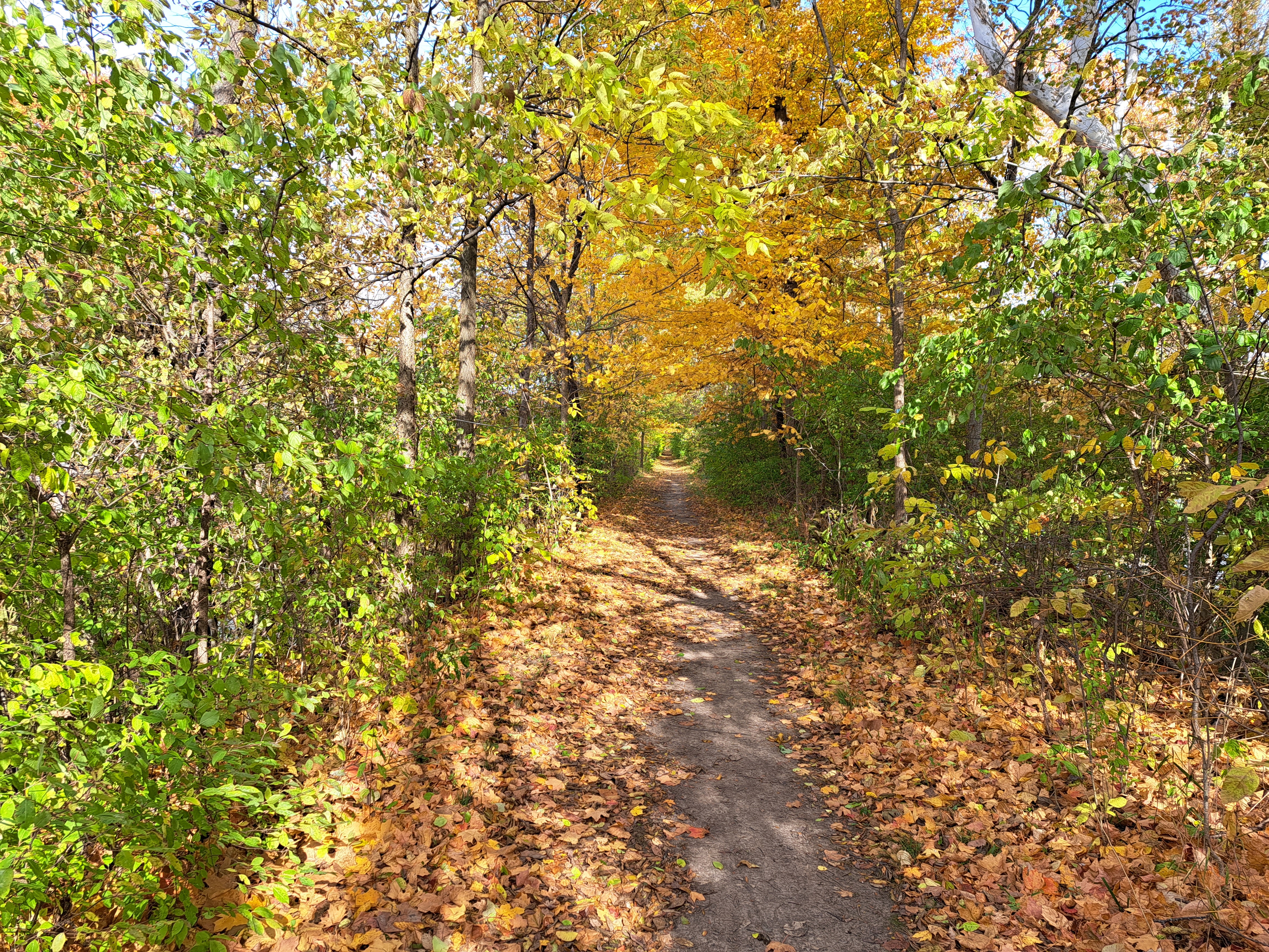
        From the signed trailhead at the back left corner of the mowed-grass area around the 50 Springs picnic shelter, the wide dirt trail heads southwest into young forest.  The Perimeter Trail is marked with yellow blazes, and while the blazes are not particularly plentiful, they exist where you need them to stay on the route.  After only 0.15 miles, you reach a trail intersection.  The option going right leads to the 50 Springs Loop, which encircles its namesake area.  Angle left to stay on the Perimeter Trail and head for the pioneer village.
Hiking the Perimeter Trail
    
        Next the trail dips through the first of many steep but shallow ravines.  The difference between maximum and minimum elevations on this hike is only about 75 vertical feet, but there is a lot of up and down on this hike.  The forest on the next ridge is quite young, and it features some red cedar trees along with some osage orange trees.  Both of these trees indicate that this land was farmed in the not too distant past.
Old barbed wire fence
    
        At 0.5 miles, the trail curves left to start following an old barbed wire fence, another remnant of this land's agricultural past.  A pond with lots of lily pads appears downhill to the right.  At 0.7 miles, you cross a bridge over Jonahs Run.  A small scenic waterfall named Crawdad Falls sits just below this bridge, but the seasonally dry conditions ensured that no water was falling when I hiked here in late October.
Jonahs Run and Crawdad Falls
    
        Some black walnut trees appear in the forest before you intersect an old asphalt road at 0.8 miles; this road is closed to vehicles.  As directed by signs and yellow blazes, you want to turn left to hike 0.2 miles uphill on the old road before turning right to reenter the forest on single track dirt trail.  The young forest with a dense understory of honeysuckle continues, as do the shallow but steep ravines.
Pioneer village across a field
Log cabin in pioneer village
    
        At 1.7 miles, you reach Pioneer Village Road, an asphalt road that is open to vehicles.  Turn right and hike a short distance on the road to reach the pioneer village.  The village consists of 25 structures, most of which were moved here from other points in the Caesar Creek area; some of them would have been submerged by the construction of Caesar Creek Lake.  The structures include several log cabins, a couple of barns, a general store, and a meeting house.  The Perimeter Trail traces a 13 mile loop around the southern portion of Caesar Creek Lake, but the pioneer village is a nice turnaround point for a dayhike.  Thus, I turned around here and retraced my steps to the 50 Springs area to complete my hike.

Thursday, November 24, 2022

Little Miami State Park: SR 350 to I-71 Bridge (Blog Hike #912)

Trail: Little Miami Scenic Trail
Hike Location: Little Miami State Park
Geographic Location: north of Morrow, OH (39.40784, -84.09930)
Length: 1.8 miles
Difficulty: 1/10 (Easy)
Date Hiked: October 2022
Overview: An out-and-back on paved bike trail that passes under the tallest interstate bridge in Ohio.
Park Information: https://ohiodnr.gov/go-and-do/plan-a-visit/find-a-property/little-miami-state-park
Hike Route Map: https://www.mappedometer.com/?maproute=924275
Photo Highlight:
Hike Video: 

Directions to the trailhead: Northeast of Cincinnati, take I-71 to SR 123 (exit 32).  Exit, go east on SR 123, then almost immediately turn left on SR 350.  Drive SR 350 east 2.9 miles, descending into the Little Miami River gorge on the way, to the signed parking for the Little Miami Scenic Trail on either side of the road.  Park here.

The hike: Rail trails make for terrible hiking.  The long, straight, flat stretches that characterize rail trails cause the scenery to change mundanely slowly when you travel at hiking speed.  Bikes whiz by at scary speeds, and usually noise from nearby highways ruins any solitude.
            Yet rail trails also have their advantages, and occasionally a good hike will be had on a rail trail.  The asphalt surface means that the hiking remains pleasant in the winter when dirt trails are too snowy or muddy, a fact I took advantage of many times when I lived in Ohio many years ago.  Also, not every segment of every rail trail stays close to a highway, so some peace and solitude can be had if you choose your rail trail hike carefully.
            Possibly the best rail trail in southwest Ohio is the Little Miami Scenic Trail, part of which is maintained by the State of Ohio as Little Miami State Park.  The trail stays close to the scenic Little Miami River for most of its distance, and it has several rural segments that see minimal bike traffic.  One of those segments is the segment described here, which follows a narrow strip of land between the Little Miami River and a steep hillside.  Even better, this hike takes you under the highest interstate bridge in Ohio: I-71's Jeremiah Morrow Bridge over the Little Miami River.
SR 350 trailhead
    
        Starting from the SR 350 trailhead, head north on the asphalt Little Miami Scenic Trail.  A sign at the trailhead tells you that the community of Oregonia is 3.3 miles ahead.  The trail travels through some nice forest, which is dominated by maple trees.
Hiking the rail trail
    
        At first the Little Miami River stays out of sight to the left.  Near 0.5 miles, the gorge tightens and the trail is forced into a tight corridor between the river on the left and a steep 150-foot bluff on the right.  The trail is the only way to access this portion of the gorge, so the setting is serene and pleasant with a decent amount of solitude.
North bridge support
Jeremiah Morrow Bridge
Bridge over Little Miami River
    
        As you approach 0.9 miles, I-71's Jeremiah Morrow Bridge comes into view above you.  Named for the 9th Governor of Ohio, who held the office from 1813-1819, the Jeremiah Morrow Bridge consists of two concrete box girder spans that were built between 2010 and 2016.  The bridges tower 239 feet above the river, and they make an impressive if man-made sight that most people only see from above.  The trail continues for many miles past the bridge, but I chose to turn around here and retrace my steps to the SR 350 trailhead to complete the hike.

Monday, November 21, 2022

Walter J. Hayes State Park: Red Trail (Blog Hike #911)

Trail: Red Trail
Hike Location: Walter J. Hayes State Park
Geographic Location: east of Brooklyn, MI (42.06846, -84.13196)
Length: 0.9 miles
Difficulty: 1/10 (Easy)
Date Hiked: October 2022
Overview: A short campground loop through kettle and kame topography.
Park Information: https://www2.dnr.state.mi.us/ParksandTrails/Details.aspx?id=454&type=SPRK
Hike Route Map: https://www.mappedometer.com/?maproute=924146
Photo Highlight:
Hike Video: 

Directions to the trailhead: From the junction of SR 50 and US 12 in Brooklyn, take US 12 east 4.3 miles to SR 124 and turn left on SR 124.  Drive SR 124 north 0.7 miles to the park's campground entrance on the right.  Turn right to enter the campground, pay the entrance fee, and drive the main campground road 0.4 miles to the paved canoe launch parking lot on Round Lake.  Park here.

The hike: Located in the heart of the Irish Hills, a scenic area with low hills in southern Michigan, Walter J. Hayes State Park protects 694 acres beside two lakes: Wamplers Lake and Round Lake.  The park came to be in 1920 when the State of Michigan purchased 99 acres to go with two other land donations.  The park was originally named Cedar Hills State Park and/or Adrian State Park due to its proximity to the city of Adrian, but in 1930 Michigan State Senator Walter J. Hayes made an additional land donation.  That donation came with the stipulation that the park's name be changed to what it is today.
            From 1933 until 1935 the Civilian Conservation Corps (CCC) worked here, making improvements to the park.  The park offers several amenities, including fishing and boating on the two lakes, a swimming beach on Wamplers Lake, some picnic areas, a 185-site developed campground, and 2 cabins.  For hikers, the park offers 2 short trails around the campground: the 1 mile Red Trail and the 0.5 mile Blue Trail.  The longer of those two options is described here.
Start of Red Trail at canoe launch
    
        You can start the Red Trail either at the campground or at the canoe launch.  Because I did not have a camping reservation, I chose to start at the canoe launch.  Marked by small red arrows attached to wooden posts, the Red Trail heads into the woods with Round Lake to your left.  The forest here features some large 
maple trees, and after only a couple hundred feet you reach the best view of Round Lake on this hike.
Round Lake
    
        Past the lake view, the trail climbs a 40-foot bluff and curves right to start heading south.  At 0.3 miles, you dip to cross the park road that connects the two main camping areas.  The wide mowed-grass trail undulates slightly with a tiny kettle lake downhill to your left and a kame uphill to your right.  Both kettle lakes and kames were formed by retreating glaciers.  Kettle lakes formed in depressions created by blocks of ice that got buried under sediment before melting, and kames formed where melting glaciers piled up dirt and gravel.
Hiking between kettle and kame
    
        Just past 0.4 miles, the Blue Trail enters from the left.  Turn right as the combined Red/Blue Trail maintains a fairly level course with another tiny kettle lake to the left and the same kame to your right.  Near 0.6 miles, the Red and Blue Trails part ways.  If you wanted to extend your hike, you could turn left and add on the Blue Trail.  As directed by the colored arrows, I turned right to continue the Red Trail.
Approaching the campground
    
        After only a couple hundred more feet, the Red Trail ends at the campground between sites #64 and #66.  To get back to the canoe launch, turn right on the campground road, walk around the restroom building, and ignore the loop for sites #80-96 on the right.  Continuing to walk north will bring you to site #1 and the main park road, where a left turn will take you downhill to the canoe launch to complete the hike.

Friday, November 18, 2022

Lake Hudson Recreation Area (Blog Hike #910)

Trail: (unnamed)
Hike Location: Lake Hudson Recreation Area 
Geographic Location: east of Hudson, MI (41.83756, -84.24577)
Length: 3 miles
Difficulty: 3/10 (Easy/Moderate)
Date Hiked: October 2022
Overview: A mostly flat out-and-back near the shore of Lake Hudson.
Park Information: https://www2.dnr.state.mi.us/parksandtrails/details.aspx?id=464&type=SPRK
Hike Route Map: https://www.mappedometer.com/?maproute=924145
Photo Highlight:
Hike Video: 

Directions to the trailhead: From Hudson, take SR 34 east 6.5 miles to SR 156 and turn right on SR 156.  Drive SR 156 south 1.5 miles to the signed recreation area entrance on the right.  Turn right to enter the area, pay the entrance fee, and then turn right at the first side road to head for the picnic pavilion.  Park in the paved lot for the pavilion.

The hike: Established only in 1979, Lake Hudson Recreation Area protects 2796 acres around its namesake lake.  Lake Hudson is unusual because it actually comprises three smaller lakes that were unified by the construction of Lake Hudson's dam.  The lake is only 24 feet deep, but it offers excellent fishing, especially for walleye and muskellunge.  Also, in 1993 the lake was named a dark sky preserve for observation of the nighttime sky.
            The recreation area is only open April through November, and its limited amenities include a 50-site campground, a single boat launch, and a picnic area.  Hikers have only one option: the 1.5 mile out-and-back trail connecting the picnic area, boat launch, and campground.  Such is the trail described here.
Trailhead near picnic pavilion
    
        The trail starts at the back left (southwest) corner of the mowed-grass area around the picnic pavilion.  A small brown sign gives distances to several points along this trail, although these distances were not particularly accurate according to my calculations.  The trail heads into a shrubby meadow area that demonstrates how young this park is.  I heard a lot of birds in the bushes, but the density of the understory prevented me from seeing many.  I did step over a large number of crickets hopping in front of me on this trail.
Hiking through the beach area
    
        At 0.5 miles, you enter the park's beach area.  I was the only person at this beach on the chilly Friday morning that I hiked here, but the beach gave me my first broad Lake Hudson view.  Some picnic tables offer an opportunity to sit, observe the lake, and see what you can see.  I managed to see a pair of swans swimming in the lake.
Swans in Lake Hudson
    
        Past the beach area, the trail reenters the young shrubby forest that now features a few larger trees.  Just shy of 1 mile, you reach the park's boat launch.  Unlike the vacant beach area, there were several people launching boats on Lake Hudson when I hiked through here.  Stay to the left of the parking area, pass a vault toilet, and angle left to again reenter the lakeside woods.
Lake Hudson's dam
Hiking through mature oak forest
    
        The last segment of trail from the boat launch to the campground is my favorite part of this hike.  Not only do nice lake views emerge, but also the trail passes through the park's most mature forest, which features some large oak trees.  After crossing the dam that forms Lake Hudson, the trail ends at the campground.  Walking back along the park road is both longer and less scenic than the trail, so your best option is to retrace your steps along the trail to the picnic pavilion to complete the hike.

Thursday, November 17, 2022

Chain O' Lakes State Park: Trail #5 (Blog Hike #909)

Trail: Trail #5
Hike Location: Chain O' Lakes State Park
Geographic Location: south of Albion, IN (41.33014, -85.38315)
Length: 1.8 miles
Difficulty: 2/10 (Easy)
Date Hiked: October 2022
Overview: A circumnavigation of Sand Lake.
Park Information: https://www.in.gov/dnr/state-parks/parks-lakes/chain-o-lakes-state-park/
Hike Route Map: https://www.mappedometer.com/?maproute=924074
Photo Highlight:
Hike Video: 

Directions to the trailhead: In northeast Indiana, the state park entrance is located on SR 9 4 miles south of Albion or 3.7 miles north of SR 9's intersection with US 33.  Enter the park, pay the park entrance fee, and drive the main park road 1.6 miles from the gatehouse to arrive at a Y-intersection.  Angle right and drive another 0.3 miles to the large Nature Center/beach parking lot.  Park as close to the Nature Center as possible.

The hike: For my general comments on Indiana's Chain O' Lakes State Park, see the previous hike.  This hike offers a fairly flat circumnavigation of Sand Lake, which is the largest and most developed of this park's 9 connected kettle lakes.  What this hike lacks in solitude it makes up for in ease and aquatic scenery.
Start of Trail #5
    
        Start at the left (west) side of the Nature Center, and turn left to begin a clockwise journey around Sand Lake on Trail #5 with the lake to your right.  At the first intersection, where Trail #12 continues straight and uphill, turn right to remain on Trail #5.  The first part of the trail passes through nice lakeside forest; this forest is dominated by sycamore and hickory trees.  Also, this hike is part of the Indiana Birding Trail, and I did some nice late afternoon bird watching here that included robins, woodpeckers, and juncos.
Rounding the west side of Sand Lake
    
        At 0.6 miles, the trail curves right to round the west end of Sand Lake.  Sand Lake has a kidney shape, and some of the longest views down the lake can be had near the lake's western end.  Trails #12, #4, and #7 exit to the left in that order, but in each case you want to stay right to remain on Trail #5.
Sand Lake near channel to Weber Lake
    
        At 0.9 miles, you cross the channel that connects Sand and Weber Lakes.  After tracing Sand Lake's north shore, you enter a more developed area of the park.  Stay close to the water as you pass the fishing pier, boat launch, and paddleboat rental areas while rounding the east end of Sand Lake.  There are few trail markers here, but Trail #5 just follows the edge of the lake.  The last leg of this hike uses asphalt trail that ends at the east side of the Nature Center.  Returning to the Nature Center signals the end of this hike.

Wednesday, November 16, 2022

Chain O' Lakes State Park: Trails #8 and #2 (Blog Hike #908)

Trails: #8, #2, and #1
Hike Location: Chain O' Lakes State Park
Geographic Location: south of Albion, IN (41.33802, -85.36574)
Length: 2.2 miles
Difficulty: 4/10 (Moderate)
Date Hiked: October 2022
Overview: A lollipop loop passing 4 kettle lakes.
Park Information: https://www.in.gov/dnr/state-parks/parks-lakes/chain-o-lakes-state-park/
Hike Route Map: https://www.mappedometer.com/?maproute=924073
Photo Highlight:
Hike Video:

Directions to the trailhead: In northeast Indiana, the state park entrance is located on SR 9 4 miles south of Albion or 3.7 miles north of SR 9's intersection with US 33.  Enter the park, pay the park entrance fee, and turn left at the first intersection.  Drive another 1.3 miles to the parking lot for Trail #8 on the left.  Park here.

The hike: Established in 1960, Indiana's Chain O' Lakes State Park protects 2718 acres around 9 connected kettle lakes.  The lakes were formed at the end of the last ice age when remnant pieces of retreating glacier ice got buried by sediment.  When the buried ice finally melted, the resulting depression filled up with water to form the lake.
            The park is a major destination for paddlers, who enjoy paddling and portaging from lake to lake.  The park also features fishing and swimming on select lakes, several picnic shelters, a 331-site developed campground, some cabins, and 12 hiking trails totaling more than 22 miles.  This hike explores 4 of the park's kettle lakes, and it also features the historic Stanley Schoolhouse.
Stanley Schoolhouse
    
        The Stanley Schoolhouse stands at the trailhead, which is across the road from the parking lot.  The brick structure you see today dates to 1915, but a school has stood on this location since 1848.  This school served all four sections (demarcated rectangles of land within a township) that meet at this point, so no student had to walk more than 2 miles to get to school.  The building was closed for the season when I came here on a seasonally cold afternoon in mid-October, so I had to admire the old schoolhouse from the outside.
Trail #8 trailhead
    
        Trail #8 starts to the right (north) of the school building and heads into the woods.  Numbered posts correspond to an interpretive guide that is available at the park's gatehouse; it describes common trees found in this forest including
 oaks, hickories, and black walnuts.  The trail dips to pass tiny Turtle Pond and then rises to reach a trail intersection where Trail #8 splits to form its loop.  To follow the interpretive guide numbers in increasing order, I chose to turn right here and use the trail going left as my return route, thus hiking the loop counter-clockwise.
Hiking Trail #8 on the ridge
    
        The trail heads west on a ridge with Finster Lake, one of the park's smaller kettle lakes, downhill through the trees to the left.  At 0.3 miles, you reach another trail intersection.  Trail #8 angles left to continue its loop around Finster Lake.  We will return to Trail #8 later, but to see some more of the park's lakes, turn right to begin an unnumbered connector trail.
            The connector trail continues our westward course as it winds and descends, sometimes steeply for short sections.  The difference between maximum and minimum elevation on this hike is only about 60 vertical feet, so all steep sections are short-lived.  At 0.7 miles, you reach the other end of the connector trail near the shore of Bowen Lake.  Turn right to begin heading counterclockwise around Trail #2, which circles Bowen Lake.
Approaching Bowen Lake
    
        With a maximum depth of 65 feet, Bowen Lake is this park's deepest lake.  I noticed some trees with knawed trunks as I walked around this lake, and later in nearby Finster Lake I saw an actual beaver lodge.  Just shy of 1 mile, the trail climbs slightly to head toward the parking lot for Trail #2.  At the next trail intersection, turn left to continue Trail #2's loop and quickly return to the lakeside area.
Bowen Lake
    
        1.2 miles into the hike, Trail #7 exits right just before you cross the channel connecting Bowen and Sand Lakes on a nice wooden footbridge.  The narrow channel and tan-colored water give this area a north woods feel you would typically find in northern Wisconsin, Minnesota, or Michigan.  After crossing a small ridge, you cross another channel.  This channel connects Bowen and Dock Lakes.
Channel connecting Bowen and Dock Lakes
    
        After crossing the second channel, you reach a major trail intersection.  You have several options to choose from here, but I recommend staying right to leave Trail #2 and begin following Trail #1.  This section of Trail #1 traces a narrow flat area between a steep hill on the left and Dock Lake on the right.  Some nice sycamore trees live in this area, and the hiking is quite pleasant.
Trail #1 near Dock Lake
    
        At 1.7 miles, Trail #1 crosses another channel to intersect Trail #6.  Instead of crossing this channel, turn left on an unnumbered connector trail to head back to Trail #8.  The connector trail climbs slightly and reaches Trail #8 at the shore of Finster Lake at 1.8 miles.  Turn right to begin the final leg of Trail #8.
Finster Lake
    
        After staying near the lake for a short distance, the trail climbs moderately to reach a bench that makes a nice resting spot.  A short distance atop the ridge closes Trail #8's loop.  Turn right to return to the Stanley Schoolhouse and complete the hike.  If you are up for more hiking and want to see another of this park's lakes, try the relatively flat Trail #5, which circles Sand Lake, this park's largest lake.

Tuesday, November 15, 2022

Independence Dam State Park: Towpath Trail (Blog Hike #907)

Trail: Towpath Trail
Hike Location: Independence Dam State Park
Geographic Location: east of Defiance, OH (41.29177, -84.25544)
Length: 2.8 miles
Difficulty: 1/10 (Easy)
Date Hiked: October 2022
Overview: An out-and-back on the old Miami and Erie Canal towpath.
Park Information: https://ohiodnr.gov/go-and-do/plan-a-visit/find-a-property/independence-dam-state-park
Hike Route Map: https://www.mappedometer.com/?maproute=924026
Photo Highlight:
Hike Video: 

Directions to the trailhead: On the east side of Defiance, take US 24 to SR 281 (exit 28).  Exit and go south on SR 281.  Drive SR 281 south 1.1 miles to CR 424.  Turn left twice to go east on CR 424.  Drive CR 424 east 2 miles to the state park entrance on the right.  Turn right to enter the park, pass an old canal lock and Independence Dam, and drive the main park road 1.6 miles to the parking lot at the campground entrance.  Unless you have a camping reservation, you will need to park here and walk through the campground to the Towpath Trail's trailhead.

The hike: Established in 1949, Independence Dam State Park protects a narrow spit of land between the Maumee River to the south and the old Miami and Erie Canal to the north.  The Miami and Erie Canal allowed boat traffic to travel between Cincinnati and Toledo by connecting the Great Miami River to the south with Lake Erie via the Maumee and Auglaize Rivers to the north.  In fact, the confluence of the Auglaize and Maumee Rivers is located in Defiance just a few miles upstream from this park.
            The canal operated for only a few years in the mid 1800's before it was replaced by the railroad, but its legacy is seen all over this park today.  The park's name refers to a wooden dam built in the 1800's that provided the water necessary to keep boats in the canal afloat.  The wooden dam was replaced by a concrete structure in 1924, and that structure can still be seen in the Maumee River near the park's entrance today.
Independence Dam
    
        Due to its unusual shape, the park offers only limited amenities: boating and fishing on the Maumee River, several picnic shelters, and a 25 site developed campground.  The park also contains a trailhead for the Miami and Erie Towpath Trail, which starts here and continues many miles to the east.  This hike explores the westernmost 1.25 miles of the Towpath Trail.
Towpath Trail trailhead
    
        Unless you happen to have a campground reservation here, this hike starts with a walk through the campground.  Stay on the road to the left with the campsites on your right.  At the rear of the campground, a large wooden sign that reads "Miami and Wabash Canal Towpath Trail" marks the trailhead.  Note that the Buckeye Trail, the 1440 mile around the state route, runs conjointly with the Towpath Trail here.  The Buckeye Trail is marked with powder blue blazes, and you will see many of them on this hike.
Hiking the Towpath Trail
    
        In some sense this is a boring hike because the scenery never changes: the old canal remains to the left and the Maumee River remains to the right for as long as you are hiking eastbound.  On the other hand, the wide flat old towpath makes for easy hiking, and there are some interesting little things to see if you look carefully.  For example, if you look in the canal only a few hundred feet from the trailhead, you will see some stone piers that probably supported a bridge at one time.
Still on the Towpath Trail
Maumee River
    
        Distance markers appear on wooden posts at 0.25 mile increments; these markers were erected by Tyler Shafer as an Eagle Scout project.  The forest along the towpath is dominated by
sycamore trees with a dense understory of honeysuckle.  1.25 miles from the trailhead, you reach a bench with a nice view of the Maumee River.  The trail continues east for many miles, but I came here late in the day and needed to get back to my car before sunset.  Thus, I turned around here and retraced my steps to my car to complete my hike.

Saturday, November 12, 2022

Pokagon State Park: Trails #3 and #6 (Blog Hike #906)

Trails: #3 and #6
Hike Location: Pokagon State Park
Geographic Location: north of Angola, IN (41.70410, -85.02195)
Length: 3 miles
Difficulty: 4/10 (Moderate)
Date Hiked: October 2022
Overview: A loop hike featuring glacier-formed kames and kettle lakes.
Park Information: https://www.in.gov/dnr/state-parks/parks-lakes/pokagon-state-parktrine-state-recreation-area/
Hike Route Map: https://www.mappedometer.com/?maproute=923863
Photo Highlight:
Hike Video: 

Directions to the trailhead: In extreme northeast Indiana, take I-69 to SR 127 and SR 727 (exit 352).  Exit and go west on SR 727, which deadends at the park.  Pay the park entrance fee, and drive the main park road to the parking lot for the park's Potawatomi Inn.  Park in the far back left (northeast) corner of the large parking lot, where Trail #3 begins.

The hike: Occupying 1260 acres of glacier-created landforms, Pokagon State Park (pronounced like poe-KAY-gun) is the northeastern-most state park in Indiana.  The land began its life as public parkland in 1925 with the formation of Lake James State Park, Indiana's fifth state park.  Although the park is located on the bank of Lake James, a few years later the park's name was changed to honor Leopold and Simon Pokagon, a famous father-son duo of Potawatomi chiefs who lived in this area in the 1800's.
            Many of the park's trails and structures were built by the Civilian Conservation Corps (CCC), which lived and worked here from 1934 until 1942.  Perhaps the park's most famous amenity is its toboggan run.  During the winter, the twin-track structure hurtles tobogganers downhill for a quarter-mile at speeds reaching 35-40 miles per hour.  The park also features the Potawatomi Inn, part of which dates to 1927, and a 273-site developed campground.  Boating, swimming, and fishing on Lake James, a nature center, numerous picnic shelters, and a playground round out the amenities.
            For hikers, the park offers 9 trails that total nearly 14 miles in length.  All of these trails let you experience the glacier-created kettle and kame topography for which this region is famous, but the park's most popular trail is the 2.2 mile Trail #3 because it takes you to the park's tallest kames and biggest kettles.  Tacking on Trail #6 as an extra loop off of Trail #3 forms the hike described here.
Trailhead near Potawatomi Inn
    
        From the northeast corner of the inn's parking area, a simple black wooden sign that says "Trail 3" identifies the trailhead.  The trail crosses a short entrance boardwalk, and after only a couple hundred feet it splits to form its loop.  This description will turn left here and use the trail going right as our return route, thus hiking Trail #3's loop clockwise.
            At the next trail intersection, you need to turn right to stay on Trail #3 and climb the first kame.  A kame is a mound of dirt or gravel deposited by a retreating glacier, and northeast Indiana has many of them.  This climb is short but steep, and soon you reach the top and start a gradual descent.
Climbing the first kame
    
        At 0.3 miles, you cross the park entrance road.  Ignore Trail #2, a trail also open to horses that enters and exits to the left.  All of the trail intersections are well-marked, so route-finding is easy: just keep following Trail #3.  Some nice mature forest occupies this part of the park, and it features some 
tulip poplar, oak, hickory, and some pine plantings.  The fall colors were quite nice when I hiked here 
on a cold wet morning in mid-October.
Hiking through nice forest
    
        After passing intersections with Trails #7, #8, and #9, you climb a set of wooden steps to reach Hell's Point just past 1 mile into the hike.  Hell's Point is another kame, and at roughly 1080 feet of elevation, it is the highest point in Pokagon State Park.  An observation deck with a bench sits atop this kame, but the unspectacular view looks out only at trees.
View from observation deck
    
        Next the trail curves right as it descends the other side of the kame.  The next 0.8 miles pass through rolling terrain that features some forest and also some wetlands.  The wide trail makes for rather easy going.  Continue straight through intersections with Trail #9 and the park entrance road.
            At 1.9 miles, you reach an intersection with Trail #6.  For the shortest route back to the trailhead, you would turn right here to continue on Trail #3.  To extend your hike through kettle and kame topography, turn left to begin Trail #6.
Hiking Trail #6
    
        Trail #6 features more of the undulations and broadleaf forest you have become accustomed to.  Views of Lake Charles, a private lake just beyond the park's southern boundary, can be had to the left.  At 2.5 miles, you reach the other end of Trail #6 where it returns to Trail #3.  Turn left to continue a clockwise journey around Trail #3.
Boardwalk through wetland
Lake Lonidaw
Lake Lonidaw
    
        Soon Trail #3 breaks out of the forest and enters a wetland that contains a large number of cattails and grasses.  After crossing the wetland and a creek on a boardwalk, a spur trail to Lake Lonidaw exits right.  Turn right to hike the short spur to the lake, which is a small but attractive kettle lake surrounded by wetland and woods.  Back on the main trail, you close Trail #3's loop in only a few hundred more feet.  Turn left to return to the inn's parking lot and complete the hike.