Thursday, August 18, 2016

Blue Ridge Parkway: Mount Pisgah Trail (Blog Hike #605)

Trail: Mount Pisgah Trail
Hike Location: Blue Ridge Parkway, Mount Pisgah
Geographic Location: southwest of Asheville, NC (35.41864, -82.74792)
Length: 2.8 miles
Difficulty: 8/10 (Moderate/Difficult)
Date Hiked: August 2016
Overview: A rocky out-and-back, fairly flat at first but steep near the end, to the summit of Mount Pisgah.
Hike Route Map: https://www.mappedometer.com/?maproute=731365
Photo Highlight:

Directions to the trailhead: From Asheville, drive the Blue Ridge Parkway south to the signed Mount Pisgah parking area access road on the left.  This road is reached at Parkway mile marker 407.6.  Turn left onto the access road, and drive it uphill to the blacktop parking lot at its end.

The hike: As you leave Asheville and start the Blue Ridge Parkway’s southern-most segment toward Great Smoky Mountains National Park, the first major recreation area you reach is the Mount Pisgah Campground and Visitor Center.  At almost 5000 feet in elevation, the Mount Pisgah base area is regionally famous for cool summer temperatures and fantastic views.  The area offers a 140-site campground, the rustic 51-room Pisgah Inn, a restaurant, a picnic area, and a gift shop.
5721 foot Mount Pisgah gets its name from the mountain in Deuteronomy from which Moses first looked on the land God promised to Israel.  The observation deck at the mountain’s summit is only accessible by hiking the rocky 1.4 mile one-way Mount Pisgah Trail described here, which gains 715 feet of elevation.  Despite the trail’s difficulty, the outstanding view and the trailhead’s location along the Parkway make this hike rather popular in the summer.  Try to plan a weekday or shoulder-season visit to minimize the crowds.
Trailhead: Mount Pisgah Trail
The trail starts at an information board at the rear of the parking lot.  Almost immediately the trail to the base area campground and picnic area exits left.  Continue straight to head for the summit of Mount Pisgah.  At just over 0.1 miles, you pass a large rock outcrop on the right that kids (and some adults) will enjoy climbing.
Large rock outcrop
The rocky trail makes a sweeping curve to the right as it climbs gradually.  At 0.6 miles, you reach the crest of Pisgah Ridge in a high saddle between Mount Pisgah to the west and Little Pisgah Mountain to the east.  The trail curves west here, and soon the grade intensifies.  Some rock steps aid the hiker, but overall for the rest of the trail the terrain is rugged and the going slow.
Climbing on rocky trail
Near 1 mile into the hike, you have to climb up a short rock outcrop that will probably require you to use your hands as well as your feet.  More stone steps bring you to a switchback and your first good view at 1.1 miles.  This vista points south toward the Mount Pisgah base area and lower hills beyond.
View south from Mount Pisgah

View west from Mount Pisgah
A pair of switchbacks raises the trail higher, and soon you enter a mountain laurel tunnel.  When you see the WLOS TV and radio tower through the trees ahead, you have almost made it to the summit.  A few more twists and turns bring you to the summit’s wooden observation platform, which was built in 1979 by the Youth Conservation Corps.  Although the TV tower blocks the view to the north, the view in the other three directions is excellent.  Cold Mountain and Black Balsam Knob dominate the view to the west, while Black Mountain stands to the south.  The only trail to this summit is the one you hiked up, so after taking in the view you have to retrace your steps 1.4 miles downhill to the parking area to complete the hike.

Wednesday, August 17, 2016

Blacklick Woods Metro Park: Buttonbush, Maple, and Beech Trails (Blog Hike #604)

Trails: Buttonbush, Maple, and Beech Trails
Hike Location: Blacklick Woods Metro Park
Geographic Location: south side of Reynoldsburg, OH (39.93343, -82.80601)
Length: 2.2 miles
Difficulty: 1/10 (Easy)
Date Hiked: August 2016
Overview: A trio of nearly flat loops through older growth forest.
Hike Route Map: https://www.mappedometer.com/?maproute=940170
Photo Highlight:

Directions to the trailhead: From Columbus, take I-70 east to Brice Road (exit 110B).  Exit and go north on Brice Rd.  Drive Brice Rd. north 0.7 miles to Livingston Avenue and turn right on Livingston Ave.  Drive Livingston Ave. east 1.1 miles to the park entrance on the right.  Turn right to enter the park.  Drive the main park road to its very end at the large blacktop parking lot for the Nature Center.  From the east, take I-70 to SR 256 (exit 112), go north on SR 256 for 0.9 miles to Livingston Ave., turn left on Livingston Ave., and turn left to enter the park.

The hike: Established in 1948, 643 acre Blacklick Woods Metro Park is the oldest metro park in greater Columbus.  The park came into being when Walter Tucker, Metro Parks’ first director, responded to a real estate ad in the newspaper.  The land’s long history as parkland ensures that the park’s beech/maple upland forest and burr oak swamp forest are among the best forests in central Ohio.
            The park features many amenities including two golf courses (a regulation course and an executive course), two large picnic areas, and the Beech-Maple Lodge, which is available for rental.  The park also contains trailheads for two paved bike trails: the Blacklick Creek Greenway Trail, which goes south to nearby Pickerington Ponds Metro Park, and the Blacklick-Huber Park Connector Trail, which runs near the golf courses.  A 4.1 mile gravel Multipurpose Trail also winds through the park.  For hikers, the park offers three nature trails that form adjoining loops, and this hike goes around all three loops to explore all of the nature trails this park has to offer.
            From the parking lot, start by hiking the asphalt trail that leads to the Nature Center.  You will want to stop in the Nature Center either before or after your hike: it contains some interesting reptile exhibits and a large wildlife viewing window that overlooks a bird feeding area.  On my visit on a hot summer afternoon, I sat at the wildlife viewing window in the Nature Center’s air conditioning for about 20 minutes and saw raccoons, squirrels, gold finches, house finches, mourning doves, cardinals, chickadees, hummingbirds, downy woodpeckers, and a blue heron among other wildlife.
Start of Buttonbush Trail
            Upon reaching the Nature Center on the asphalt path, angle sharply left to pick up the signed Buttonbush Trail.  Traffic noise from nearby I-70 fades as you hike further north away from the interstate.  The Buttonbush Trail alternates between gravel and wooden boardwalk as it passes through a swamp forest, the lowest elevation on this hike.  The swamp forest is dominated by burr oak trees, and interpretive signs describe common plants in the forest.
            At 0.1 miles, the Buttonbush Trail splits to form its loop.  This hike continues straight on the gravel trail and uses the boardwalk going left as a return route, thus hiking the loop counterclockwise.  Soon you find yourself back on boardwalk as the trail reaches the corner of a sunny wet sedge meadow.  Some dragonflies buzzed around the meadow on the hot sunny afternoon of my hike.
Sedge meadow
            0.2 miles into the hike, the spur trail to the Maple and Beech Loops exits right.  If you wanted to hike only the 0.5 mile Buttonbush Trail, you could continue straight here as this hike will eventually.  To see all of the park’s nature trails, turn right on the spur trail, which is named the Walter Tucker Trail after Metro Parks’ first director.  At 0.3 miles, you reach the spur trail’s other end at the Maple Trail’s loop.  Turn right to begin a counterclockwise trip around the Maple Loop.
            The east arm of the Maple Trail heads north along the eastern boundary of the park’s natural area.  Although the land at Blacklick Woods is very flat, the 20 feet of elevation change between the wetland and this area allows maple and beech trees to dominate the forest here.  The flat terrain and wide firmly-packed gravel trails make all of the park’s trails passable by people in wheelchairs with some assistance.
Hiking the Maple Trail
            At 0.65 miles, you reach a junction with the Beech Loop, the northernmost of the three nature trail loops.  Keeping with the counterclockwise theme of this hike, turn right to hike the Beech Loop counterclockwise.  Some small concrete culverts carry the trail over ditches in this part of the park.
            After curving left, the trail crosses the blacktop trail that connects Beech-Maple Lodge with its parking lot.  After crossing the paved lodge access road, the trail surface turns to asphalt before coming out at a developed area of the park with picnic tables and other structures scattered about.  The trail map calls this area the Ash Grove Picnic Area, and a parking lot here provides an alternative point from which you could start this hike.
Old trading post
            Before reaching the parking lot, the asphalt trail curves left to pass an old trading post and ranger station.  Built in the 1950’s, the old trading post is one of the oldest structures in Metro Parks.  Now heading east, ignore a paved trail that exits right to reach more picnic areas.  The Beech Trail turns back to gravel as it reenters the forest at a point that contains an information board, trash can, and sign warning against pets and bicycles.
            At 1.2 miles, you reach the west arm of the Maple Trail.  Turn right here to leave the Beech Trail and begin your return journey on the Maple Trail.  The Maple Trail heads south through more nice maple/beech forest.  Where a spur trail to the picnic areas exits right at 1.4 miles, continue straight on the Maple Trail.
Boardwalk on Buttonbush Trail
            Just past 1.5 miles, you close the Maple Loop.  Turn right on the Walter Tucker spur trail, then turn right again to continue the Buttonbush Trail.  More boardwalks take you around the Buttonbush Trail’s loop, which is closed at 1.9 miles.  Turn right to head back to the Nature Center and parking lot, where your car awaits.

Sunday, August 14, 2016

Flint Ridge State Memorial (Blog Hike #603)

Trails: Quarry, Creek, and Bear Hollow Trails
Hike Location: Flint Ridge State Memorial
Geographic Location: southeast of Newark, OH (39.98875, -82.26124)
Length: 2.5 miles
Difficulty: 3/10 (Easy/Moderate)
Date Hiked: August 2016
Overview: A lightly trafficked hike featuring ancient flint quarries.
Hike Route Map: https://www.mappedometer.com/?maproute=940171
Photo Highlight:

Directions to the trailhead: From Columbus and points west, take I-70 to SR 668 (exit 141).  Exit and turn left on SR 668.  Drive SR 668 north 0.8 miles to the town of Brownsville and its end at US 40.  Turn left on US 40, then almost immediately turn right on Brownsville Road.  Drive Brownsville Rd. north 3.1 miles to Flint Ridge Road and the signed memorial on the right.  Turn right on Flint Ridge Rd., then immediately turn right to enter the memorial.  Park in the paved parking lot for the museum.  From the east, take I-70 exit 142 to US 40, drive west to the town of Brownsville, and follow the previous directions to the memorial.

The hike: Flint Ridge, an 8-mile long east-west hill in eastern Licking and western Muskingum Counties, has had a major impact on the history of eastern North America.  The ridge gets its name from some unique rainbow-colored flint deposits that people exploited for making arrowheads, tools, and ceremonial objects before European settlement.  The flint was quarried to such an extent that the ridge has been called “The Great Indian Quarry of Ohio,” and archaeologists have found Flint Ridge’s flint in artifacts throughout the entire eastern United States.  The largest quarry sites are protected today in 533 acre Flint Ridge State Memorial, which is owned by the non-profit Ohio History Connection (formerly known as the Ohio Historical Society) but managed locally by the Licking Valley Heritage Society.
            The memorial features a small museum that contains some flint artifacts and some exhibits on how flint is shaped into tools.  As of this post, the museum was only open Friday through Sunday, so I did not get to tour the museum on my Monday visit.  The memorial offers three loop trails: the Quarry Trail through the heart of the flint quarries, the Creek Trail that explores the upper reaches of a shallow ravine, and the Bear Hollow Trail, a seldom-used nature trail.  While the Quarry Trail features the greatest points of interest, this hike combines all three trails to form a grand tour of Flint Ridge.
Museum at Flint Ridge
            From the front of the museum, head south on the Quarry Trail, which is marked with lime green rectangular paint blazes.  Almost immediately you enter the quarry area.  Unlike more modern quarries that appear as deep gouges in the earth, the ancient quarries at Flint Ridge appear as a collection of shallow pits or depressions.  The trail stays on the high ground between the pits, and some short but steep ups and downs will need to be negotiated.  Some nice maple and beech trees make for a pleasant setting.
Ancient flint quarry
            The Quarry Trail makes a sweeping 180-degree left turn through the quarries.  After hiking 0.5 miles from the parking lot, you reach an intersection where the Creek Trail exits right.  If all you want to do is see the flint quarries, then you can continue straight here to head directly back to the parking lot.  This hike turns right on the yellow-blazed Creek Trail to head into the eastern part of the memorial.
            The somewhat narrow Creek Trail stays near the ridge for a short time before descending into a shallow ravine on a moderate grade.  Some unmined flint outcrops stick several inches out of the ground beside and even in the trail.  Thus, the Creek Trail gives you a feel for what the American Indians might have seen when they first came to this area.
Flint outcrop
After losing just over 100 feet of elevation, the trail curves left to cross a couple of small streams on wooden footbridges.  Watch for some poison ivy that grows beside the trail in this low area.  Another sweeping 180-degree left turn brings the trail on a westward course as it begins a gradual climb out of the ravine.
At 1.3 miles, you reach the end of the Creek Trail at its north intersection with the Quarry Trail.  Turn right to ascend gradually on the Quarry Trail and return to the parking lot, passing a couple more flint outcrops en route.  This return to the parking lot completes the first (southern) loop.  To get to the nature trail, walk back out the entrance road, cross Flint Ridge Road, and look for a wooden sign with a white blaze that says “Nature Trail” on the north side of the road.  The Bear Hollow Trail enters the woods just beyond this sign.
Start of Bear Hollow Trail
The Bear Hollow Trail is definitely not the memorial’s best trail.  The trail starts by paralleling moderately trafficked Brownsville Road before curving right to head away from the road noise.  This trail receives less traffic and maintenance than the trails near the museum, so you will have to deal with some encroaching vegetation.  Some white paint blazes keep you on the trail, and some crude log bridges get you over wet spots.
Spanning a wet area
As you approach the steep north edge of Flint Ridge, the trail forks to form its loop.  A double white blaze marks this point.  I chose to turn left here and hike the loop clockwise.  The short loop takes you through more young forest tucked between the north edge of the ridge on the left and Flint Ridge Road on the right.  Overall, the terrain remains fairly flat.  After closing the loop, retrace your steps along the “stick” of the lollipop loop Bear Hollow Trail to the parking lot to complete the hike.

Thursday, August 11, 2016

Wayne National Forest: Lamping Homestead Trail (Blog Hike #602)

Trail: Lamping Homestead Trail
Hike Location: Wayne National Forest
Geographic Location: southwest of Woodsfield, OH (39.63038, -81.18973)
Length: 3.5 miles
Difficulty: 8/10 (Moderate/Difficult)
Date Hiked: July 2016
Overview: A loop hike with plenty of up and down through a wide variety of habitats.
Hike Route Map: http://www.mappedometer.com/?maproute=544246
Photo Highlight:

Directions to the trailhead: From Woodsfield, take SR 26 south 11.4 miles to SR 537, noticing the large number of oil and natural gas wells you pass along the way.  Turn right on SR 537.  Drive SR 537 west 1.7 miles to Clearfork Road and a national forest sign for Lamping Homestead.  Turn left on Clearfork Rd.  The parking area for Lamping Homestead Recreation Area is 0.2 miles ahead on the left.  A vault toilet but no water can be found at this trailhead.

The hike: Known regionally as “the Wayne,” Wayne National Forest protects over 240,000 acres in rural and rugged southeastern Ohio.  The forest was established in 1934 to buy up land that had been depleted by decades of poor timbering and agricultural practices.  Other parts of the forest cover former coal mines.  Today the forest features over 300 miles of trails, which make the Wayne one of Ohio’s best hiking resources.
            Many of the Wayne’s trails interconnect to form large trail networks, but the Lamping Homestead Trail featured here sits by itself and connects with no other trails.  The Lamping Homestead Recreation Area is named for a family that lived on this site from the 1800’s until 1971.  After the Forest Service acquired the land, the farm buildings were dismantled, so only a small cemetery remains from the Lamping’s ownership era.  The recreation area features a 2 acre pond stocked with bluegill, bass, and catfish, 6 walk-in campsites, 8 picnic sites, a picnic shelter, and of course the trail described here.
Trailhead: Lamping Homestead Trail
            Start the hike by walking toward the left side of the fishing pond, which sits east of the parking area.  The Lamping Homestead Trail makes a loose loop around the pond, but the trailhead to the left of the pond is easier to find: look for a brown wooden sign beside a small pine planting that reads “Lamping Trail.”  Starting here and hiking the loop clockwise gets the toughest climb over with first.  Also, the area’s picnic facilities and campsites are located here.
            The trail heads up the left side of the fishing pond before curving right to cross one of the pond’s feeder streams on a wooden footbridge.  White plastic diamonds mark the way, and brown carsonite posts labeled with trail distances appear every quarter mile.  These markings and the above average trail maintenance give this hike a frontcountry feel in spite of the remote location, which keeps trail traffic down.  I did not encounter anybody else on this trail when I hiked here on a Saturday in late July.
Fishing pond
Now on the east side of the pond, the trail begins a long gradual to moderate but occasionally steep climb up a series of ravines while curving right to head south.  In addition to some steep areas, parts of this trail have high cross slope, i.e. the treadway slopes steeply from right to left or vice-versa across the side of the hill.  Therefore, I recommend boots or shoes with good ankle support for this hike.
Climbing the ridge
            Just shy of 1 mile, you enter a pine planting near the top of the ridge, which stands more than 250 feet above the pond.  When you reach the top of the hill, a trail signed as the Short Loop exits right.  As its name suggests, this trail goes downhill to shortcut the main loop, thus reducing the hike’s distance to only 1.5 miles.  Continue straight to hike the longer loop.
            Very quickly you enter a small prairie that contains a rusty old natural gas well.  While southeastern Ohio is no Permian Basin, this well and the large number of oil and natural gas wells you passed while driving to the trailhead provide evidence of the fossil fuel resources this region possesses.  The grass can wisp at your ankles in the prairie, so be sure to check yourself for ticks at the end of the hike.
Hiking through the prairie
            Back in the forest, the trail goes across the ridge to begin descending its south side.  The descent is gradual to moderate at first, but a couple of later areas are so steep that I felt more comfortable going down backward than forward.  At 1.3 miles, the trail curves right to begin heading down a steep-sided but flat-bottomed ravine.  The nice maple/beech forest here makes this hike an above average destination for fall leaf peeping.
            After 0.5 miles of fairly flat hiking, the trail curves right to begin climbing around the hillside.  When I hiked this trail, some recent side hill work had been done here to reduce the trail’s cross slope and therefore make the hiking easier.  While I did not help build this trail, my feet did their part to stamp down the newly built treadway, thereby solidifying the new construction.  Trail traffic is one of the best ways to wear in new trails.
Improved sidehill trail
            At 1.8 miles, you reach a narrow overlook of the Little Muskingum River’s Clear Fork, which was muddy on my visit.  The Little Muskingum River flows south and west from here to empty into the Ohio River just upstream from Marietta.  For the next 0.9 miles the trail passes in and out of several small ravines between finger ridges as it goes more up than down.  More pine plantings appear as you get closer to the top of the ridge.
Little Muskingum River overlook
            2.8 miles into the hike, you top out on the ridge again just below a knob that rises to the right.  Next comes a steep descent down the north side of the ridge.  Just past 3 miles, the signed Short Loop enters from the right.  Angle left to begin the final segment back to the fishing pond.
            The trail now enters young lowland forest, which contains some sycamore trees and a dense shrubby understory.  After hopping over a small ditch, you pass on the right side of a low knob before coming out at the southeast corner of the fishing pond.  Walk across the pond’s dam and through the picnic area to return to the parking lot and complete the hike.

Wednesday, August 10, 2016

Rockbridge State Nature Preserve (Blog Hike #601)

Trails: Natural Bridge and Rock Shelter Trails
Hike Location: Rockbridge State Nature Preserve
Geographic Location: west of Logan, OH (39.56633, -82.49929)
Length: 2.3 miles
Difficulty: 7/10 (Moderate/Difficult)
Dates Hiked: May 1998, July 2016
Overview: A double loop featuring the largest natural bridge in Ohio.
Hike Route Map: https://www.mappedometer.com/?maproute=804057
Photo Highlight:

Directions to the trailhead: From Logan, take US 33 west 5.8 miles to Dalton Road; there is a brown road sign for the preserve at this intersection.  Take a double right turn onto Dalton Rd.  Drive Dalton Rd. 0.8 miles to the small preserve parking lot at its end.

The hike: For my history of Hocking Hills hiking, see the previous hike.  The 202 acre Rockbridge State Nature Preserve sits in the hilly northern part of Hocking County well away from the area’s more famous and developed destinations to the south.  As its name suggests, the preserve features the largest natural bridge in Ohio.  Thus, Rockbridge’s scenery is as good as the region’s more popular areas, but the hilly terrain makes the bridge harder to access.  The preserve’s location and terrain keep the crowds down: my mother and I were the only people in the preserve on my May 1998 visit, and there were only 4 cars in the parking lot on my most recent visit on a hot July afternoon.
            Two loop trails traverse the preserve, and both loops are accessed by a common entrance trail that starts from the preserve’s only parking area.  The preserve’s steep hills make this hike one of the harder short hikes in the Hocking Hills region, and I took nearly 2 hours to hike both of the loops.  As detailed later in this trail description, you can see the natural bridge without hiking both loops, but the route described here explores all the preserve has to offer.
Trailhead: Rockbridge State Nature Preserve
            From the information kiosk beside the parking area, begin heading north through a narrow strip of natural area between two active farm fields.  The mowed-grass trail tops a low hill before heading into the woods, turning to dirt, and topping a larger, steeper hill.  Wooden boardwalks span wet areas between these two initial hills.
            At 0.5 miles and on the north side of the second hill, the trail splits to form the Natural Bridge Loop.  I chose to turn left and use the right trail as my return route, thus hiking the loop clockwise.  The trail briefly traces the north side of a farm field before curving right and beginning a steep descent into the heart of the preserve.
Hiking along a seasonal stream
            The trail reaches the bank of a seasonal stream just before coming to a major trail intersection at 0.8 miles.  The Natural Bridge Loop continues to the right, but you will first want to hike the spur trail to the natural bridge, which continues straight.  In less than 200 feet, you reach the rock bridge for which this preserve is named.  Because you approach the bridge from above, you might first notice the 10 foot wide crack in the ground that separates the bridge from the main cliff line.  The asymmetric sandstone bridge measures 100 feet long, 10-20 feet wide, and 50 feet high.  A low-volume waterfall exists between the bridge and the cliff when water levels are sufficient, which they were in May 1998 but were not in July 2016.  This bridge is the highlight of the hike, so take some time and enjoy this scenic spot.
View of natural bridge from above

View of natural bridge from side
            The trail that continues downhill past the bridge leads 0.1 miles to the south bank of the Hocking River, and it is used by paddlers to access the natural bridge.  Feel free to hike down there if you want to see the river, but the trail dead-ends at the river.  Thus, you will need to turn around and retrace your steps to the major trail intersection, which is reached for a second time 1 mile into the hike.  If all you want to do is see the bridge, then the shortest and easiest return route is to retrace your steps by continuing straight at this intersection.  To see more of the preserve, turn left to begin hiking the north arm of the Natural Bridge Loop.
            The trail angles up the hillside through nice forest consisting of many maple and beech trees.  Just shy of 1.2 miles, you reach the ridgetop and another signed trail intersection.  The Natural Bridge Loop turns right here, and this hike will go that way to finish the Natural Bridge Loop eventually.  To explore the remote northeast corner of the preserve, turn left for now to begin the seldom-used 1 mile Rock Shelter Loop Trail.
Switchback on Rock Shelter Loop Trail
            The narrow Rock Shelter Loop Trail uses two switchbacks to descend the steep north side of the ridge.  Part of this descent appears to use an old road.  Some blue surveyors tape tied around trees marks this trail, as do some wooden posts engraved with arrows.  At the bottom of the switchbacks, you pass atop the sandstone rock shelter for which this trail is named.  This rock shelter looks a little like the area near the natural bridge but without the bridge.  Maybe erosion will form a natural bridge here at some point in the future.
Rock shelter
            Past the rock shelter, the trail climbs moderately up a small ravine to reach the fork that forms the Rock Shelter Loop Trail’s loop.  To make the climb a little easier, I chose to turn left here and hike the loop clockwise.  The very short loop climbs gradually and then moderately to almost regain the ridge crest before descending steeply to close the loop.  Retrace your steps to the Natural Bridge Loop, then continue straight to begin the final segment of the Natural Bridge Loop.
            The trail drops steeply to cross a wooden footbridge that spans the seasonal stream that forms the waterfall behind the natural bridge.  A steep climb then brings you back beside the farm field to close the Natural Bridge Loop.  Continue straight to retrace your steps 0.5 miles to the trailhead, thus completing the hike.

Tuesday, August 9, 2016

Conkles Hollow State Nature Preserve (Blog Hike #600; Ohio Hike #100)

Trails: Rim and Gorge Trails
Hike Location: Conkles Hollow State Nature Preserve
Geographic Location: southwest of Logan, OH (39.45339, -82.57319)
Length: 3.4 miles
Difficulty: 5/10 (Moderate)
Dates Hiked: May 1998, July 2016
Overview: A scenic hike around and through attractive Conkles Hollow.
Hike Route Map: https://www.mappedometer.com/?maproute=731361
Photo Highlight:


Directions to the trailhead: From the intersection of SR 664 and US 33 on the west side of Logan, take SR 664 south 12.1 miles (passing Old Man’s Cave en route) to SR 374.  Turn right on SR 374.  Drive SR 374 north 1 mile to Big Pine Road and turn right on Big Pine Rd.  The preserve entrance is 0.2 miles ahead on the left.  Park either in the cul de sac at the entrance road’s end or in the paved parking area near some picnic tables at the top of the hill.

The hike: My first visit to the Hocking Hills, which many experts regard as Ohio’s best hiking destination, lasted for two days in May 1998 many years before I started even the earliest version of this blog.  That visit was a whirlwind tour of the region’s most famous sites, and it included quick stops at Rockbridge State Nature Preserve, Cantwell Cliffs, Rock House, Conkles Hollow, Old Man’s Cave, Cedar Falls, and Ash Cave.  After seeing all of the region’s scenic destinations in summary fashion, I decided that Conkles Hollow was my favorite.  Although I have made three hiking trips to the Hocking Hills since then, Conkles Hollow has remained my favorite place to hike in the area.  Thus, when I found myself in central Ohio needing to pick a destination for my 600th blog hike and 100th Ohio hike, the decision to come back to Conkles Hollow and officially add it to my blog was an easy one.
            Although the area did not become a state nature preserve until 1977, the land was purchased by the State of Ohio in 1925.  Due to the rugged terrain, this land was never farmed and rarely logged, so tall trees and old growth forest take center stage here along with the 200-foot sandstone cliffs that line the hollow.  The hollow’s name comes not from a former land owner but from an inscription on the hollow’s west rock wall that read “W.J. Conkle 1797.”  The inscription is no longer visible, but the name has stuck.
            The preserve offers two trails, a 2 mile Rim Trail that traces the hollow’s rim and the 0.5 mile one-way Gorge Trail, which takes you along the stream through the middle of the hollow.  On my first visit in 1998, I hiked only the shorter and easier Gorge Trail, but to get a full sense of the hollow’s special scenery you really need to hike both trails.  Such is the route described here.
Bridge entering Conkles Hollow
            The hike starts by crossing a long wood/iron bridge over Pine Creek.  Pine Creek does not pass through Conkles Hollow, but the small creek that does go through the hollow empties into the much larger Pine Creek at the hollow’s mouth.  Next you pass a trailhead area with information boards and kiosks on the right.  At 300 feet, the Rim and Gorge Trails part ways at a signed intersection.  Turn right to begin a counterclockwise journey around the Rim Trail.
            The Rim Trail climbs to the east rim first on constructed wooden steps, then on moderate grade dirt trail, and finally over some rock outcrops.  Some wires strung between metal posts keep you on the trail.  Although the trails at Conkles Hollow are not blazed or otherwise marked, they are well-trodden and easy to follow.  A final sharp left turn brings you to the rim, which this trail will follow for the next 1.4 miles.
Approaching the rim
            The east section of the Rim Trail alternates between sunny rock outcrops and shady forest, and very quickly the views for which this trail is famous start to emerge.  No fences or guardrails protect the cliff edge, so you have to be careful where you step.  While there are no particularly precarious spots, the edge stays close enough often enough to keep it mindful, especially if you are scared of heights like I am.  Overall, the hiking on the rim is a little rough due to rocks and roots but fairly level.
Rim view, looking down Conkles Hollow

Rim view, looking up Conkles Hollow
            At 0.7 miles, you reach an especially scenic overlook that stands over a narrow part of the hollow with a vertical sandstone cliff on the opposite side.  As you continue north along the east rim, a bridle trail called the Orange Trail can be seen in adjacent Hocking State Forest uphill and to the right.  Because the preserve only comprises 87 acres, the Rim Trail stays near the preserve’s boundary for its entire distance, so items outside the preserve such as this bridle trail will be encountered frequently along the rim.
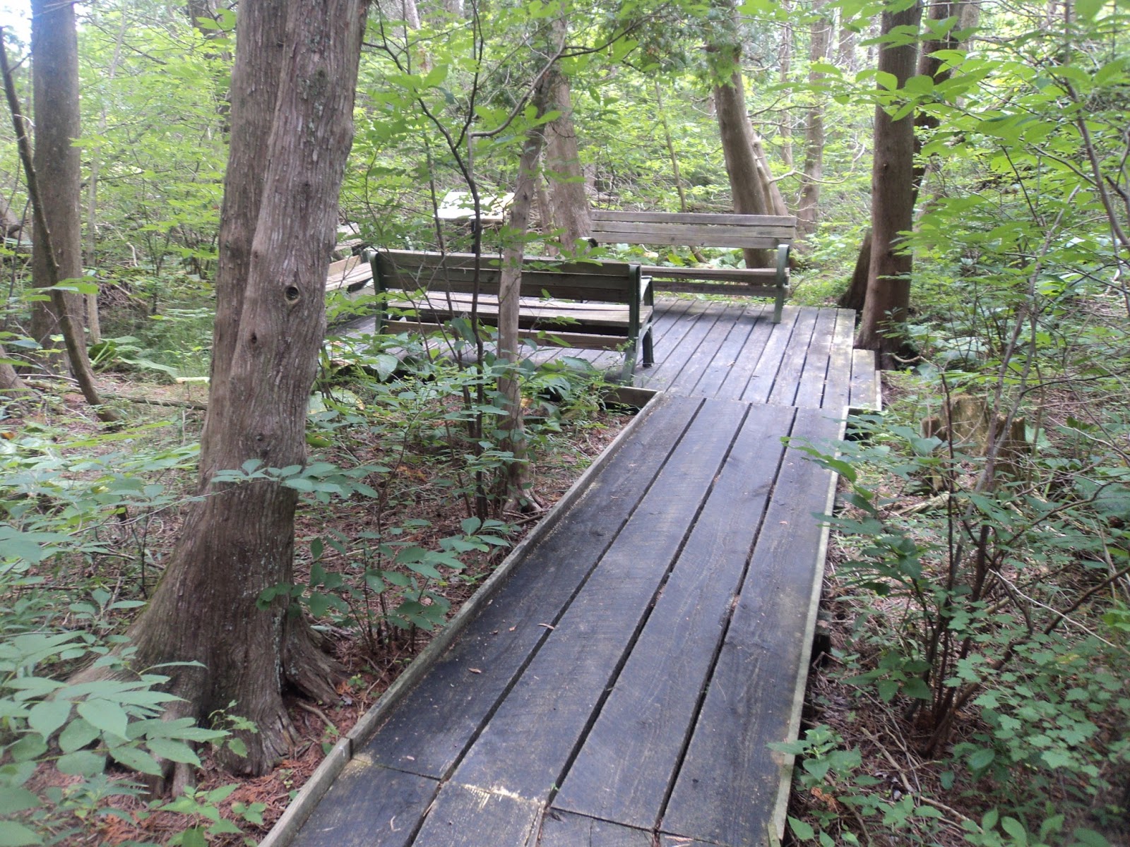
Observation platform at hollow's head
            Just shy of 1 mile, you reach a wooden platform that overlooks the head of the hollow.  The trees are too numerous here to allow any broad views like the ones you passed earlier, but some benches make nice places to rest near the midpoint of the Rim Trail.  After a brief descent on wooden steps, the trail crosses the main stream through Conkles Hollow on a wooden footbridge located just above where the creek falls into the hollow.  Some short sandstone ledges just upstream from the bridge foreshadow the interesting rocky scenery you will see later in the gorge.
Crossing creek above Conkles Hollow
            After crossing the creek, the trail curves sharply left to begin heading down the west rim.  While the state forest bridle trail bordered the preserve on the east, moderately trafficked SR 374 borders the preserve on the west, so intermittent vehicle noise will be heard on the west rim.  Also, the west rim is mostly forested with no open rock outcrops, so there are few expansive views like those found on the east rim.  In between passing cars I heard several woodpeckers while hiking through the nice pine forest on the west rim.
             The trail traces around several semicircular alcoves carved into the west rim of Conkles Hollow.  Peering down into these alcoves reveals that Conkles Hollow actually has three levels: the rim level on which you stand, the creek level where you will be in a few minutes, and a third middle level that is inaccessible by trail.  The lack of broad views on the west rim allows you to focus on the hollow’s intricate shapes and walls.
Alcove along west rim
            After a particularly close encounter with the state highway, the trail begins its descent from the rim.  The descent is steep and rocky at first, but later several sections of wooden steps ease the grade.  2.2 miles into the hike, the Rim Trail ends at its intersection with the Gorge Trail.  The parking lot and hollow’s mouth sit only a few hundred feet to the right, but this hike turns left to begin the Gorge Trail as it heads up the center of the hollow.
Concrete portion of Gorge Trail
            Unlike the pine trees that dominated on the rim, the forest in the hollow includes some sycamore and even some birch trees, which usually live in much colder climates.  The easy Gorge Trail is nearly flat, and the first part of this trail is paved with concrete, thus making it accessible for wheelchair-bound visitors.  About half way up the Gorge Trail, a nice recess cave called Diagonal Cave can be seen uphill to the right.
Diagonal Cave
            The hollow’s sheer sandstone walls close in on both sides as you get deeper into the hollow.  Just before 0.4 miles into the hollow, the wheelchair-accessible trail ends where the treadway turns to dirt.  Some large slump blocks, chunks of sandstone fallen from the surrounding cliffs, sit beside the trail.
Head of Conkles Hollow
            After a brief climb up and over a small side ridge, you cross the creek on stepping stones just before reaching the head of the hollow.  The creek makes a dramatic entrance into the hollow: a 15 foot ledge-type waterfall with a shallow plunge pool.  The waterfall was nice on my May 1998 visit but dry on my July 2016 visit.  This area also has nice acoustic qualities that make the waterfall sound bigger than it is.  The Gorge Trail ends at the hollow’s head, so after enjoying the waterfall area your only choice is to retrace your steps back out the hollow to the parking lot to complete the hike.

Saturday, August 6, 2016

Cedar Bog State Nature Preserve (Blog Hike #599)

Trail: Ralph Ramey Boardwalk Trail
Hike Location: Cedar Bog State Nature Preserve
Geographic Location: south of Urbana, OH (40.05715, -83.79231)
Length: 1 mile
Difficulty: 1/10 (Easy)
Dates Hiked: July 1995, July 2016
Overview: A boardwalk double loop through Ohio’s first state nature preserve.
Hike Route Map: http://www.mappedometer.com/?maproute=544226
Photo Highlight:

Directions to the trailhead: From Urbana, take US 68 south 4.1 miles to Woodburn Road and turn right on Woodburn Rd.  Drive Woodburn Rd. west 1 mile to the preserve entrance on the right, which is reached just after crossing a railroad track and the Simon Kenton Trail, an asphalt bike trail.  Park in the preserve’s only parking lot.

The hike: Consisting of 427 acres in southern Champaign County, Cedar Bog State Nature Preserve protects the remnant of what was once a vast wetland that stretched from Springfield to Urbana.  Like most of Ohio’s wetlands, Cedar Bog originated at the end of the last ice age, when melting glaciers left behind water and plant seeds they had transported from points further north.  The “bog” in the preserve’s name is technically a misnomer: the wetland on these grounds is not a bog with acidic soil but a fen with alkaline soil.
The rare plant communities supported by the soil’s unusual pH led the State of Ohio to purchase this wetland in 1942, thus making Cedar Bog Ohio’s first nature preserve purchased with state money.  In the 1970’s, an upgrade of US 68 to 4 lanes was proposed to come through the bog.  The preserve would have been destroyed if that proposal had been accepted, but fortunately state leaders saw the value of the unusual wetland and nixed the highway project.  In fact, US 68 through southern Champaign County remains only two lanes wide today.
            The preserve has only one trail, a 1 mile boardwalk that forms a loop with shortcut option through the heart of the wetland.  I have actually hiked the boardwalk’s main outer loop twice, once in 1995 before I started this blog and again in 2016 to form the basis of this trail description.  In between my visits, a new entrance boardwalk was built in 2006 to replace a mulch path, and a new Learning Center was built in 2009.  The preserve’s $5 entrance fee has remained constant, however.
            On a personal note, I was delighted to learn on my most recent visit that the bog’s boardwalk has been renamed the Ralph Ramey Boardwalk Trail.  As I wrote under the “About This Blog” tab, Ramey’s classic book 50 Hikes in Ohio inspired me to write about hikes, and therefore he is the main inspiration for this blog.  A former director of Ohio’s Division of Natural Areas and Preserves and a former site manager at Cedar Bog, Ramey has done more for conservation in Ohio than anybody else in this era.  All Ohioans owe him a great debt of gratitude for the fine state nature preserve system Ohio has today.
Start of boardwalk at Learning center
            From the back of the Learning Center, the boardwalk heads south before taking a 90-degree right turn to head west into a sunny prairie.  The preserve’s dedication marker sits at this turn, and numerous interpretive signs correspond to a brochure available for purchase in the Learning Center.  This boardwalk was built in 1986 at a cost of $72,500, and some side rails attached to the boardwalk ensure that wheelchairs stay on the wood.
After passing through a narrow sedge meadow, the boardwalk crosses the East Branch of Cedar Run before splitting to form its loop.  I chose to turn right here and use the left boardwalk as my return route, thus hiking the loop counterclockwise.  The northbound boardwalk winds first through shady swamp forest and then through sunny, grassy sedge meadow.  Some areas of the bog are completely submerged, while other slightly higher areas appear only muddy.
Sedge meadow

Cedar forest
At 0.2 miles, the boardwalk briefly passes through a cedar forest, a plant community that rarely lives this far south, before curving left to head back through the sedge meadow and then the swamp forest.  Large quantities of skunk cabbage live in the swamp forest, which also features many ash trees.  Next comes the driest part of the bog: the slightly higher savannah traversed on the northern edge of the loop.  Back in the swamp forest, the boardwalk curves left again as it approaches the West Branch of Cedar Run.
Hiking along the West Branch of Cedar Run
For the next 0.2 miles the boardwalk parallels the creek, which flows on your right.  Just past 0.5 miles, the shortcut boardwalk exits to the left.  Continue straight to hike the full loop.  A bench made out of wood from the boardwalk that preceded this one sits at this intersection.
The remaining southern part of the loop stays entirely in the swamp forest.  A woodpecker drilled into a tree above me as I hiked here on a warm summer afternoon.  More left turns take you away from the West Branch of Cedar Run as the boardwalk heads east.  The shortcut option enters from the left just before the outer loop is closed.  Angle right to walk back up the entrance boardwalk to the Learning Center and complete the hike.

Friday, August 5, 2016

Stage's Pond State Nature Preserve (Blog Hike #598)

Trails: Meadow, Kettle Hole, Multiflora, Moraine, White Oak, and Boundary Trails
Hike Location: Stage’s Pond State Nature Preserve
Geographic Location: north of Circleville, OH (39.67023, -82.93364)
Length: 2.7 miles
Difficulty: 3/10 (Easy/Moderate)
Date Hiked: July 2016
Overview: A double loop through prairie and forest past two kettle lakes.
Hike Route Map: https://www.mappedometer.com/?maproute=940172
Photo Highlight:

Directions to the trailhead: From Circleville, take US 23 north 4.8 miles to Haggerty Road and turn right on Haggerty Rd.  Drive Haggerty Rd. east 1.5 miles to the signed preserve entrance on the left.  Turn left to enter the preserve.  Assuming the vehicle gate is open, drive past the first parking lot near Haggerty Rd. to reach the paved parking lot at the preserve road’s end.  The preserve headquarters sits just beyond this parking lot.

The hike: The story of 178-acre Stage’s Pond State Nature Preserve starts many millennia ago with the glaciers that covered the northwestern two-thirds of Ohio.  The preserve is located near the southern edge of Ohio’s glaciated region, so the nearly flat glaciated terrain around Stage’s Pond contrasts greatly with the rugged, unglaciated, hilly terrain of the larger Great Seal and Scioto Trail State Parks located only a few miles to the south.  Also, the depression containing the ponds formed at the end of the last ice age when a large chunk of ice from the glaciers became buried under sediment before melting.  Therefore, while most bodies of water in Ohio result from man-made dams, the two kettle ponds on this property have natural origins. 
            Like most of Ohio’s state nature preserves, the site features no facilities except a parking lot and a trail system.  About half of the preserve is prairie and wetland while the other half is wooded, so many habitats are found in this small area.  The route suggested here explores all corners of the preserve and both of the preserve’s ponds.
Start of trail at parking area
            Start on the mowed-grass trail that heads west from the parking area.  Very quickly you pass the preserve’s dedication marker (a rock with metal plaque that was placed here on August 23, 1974) and reach a major trail intersection at an information kiosk.  Four other mowed-grass trails leave this intersection.  This trail description continues on the trail marked “waterfowl blind” that goes straight.  Note that the trail going sharply left leads to the parking area along Haggerty Rd., and the Moraine Trail going right is not used on this hike.
            A brief descent through a heavily wooded area brings you to the wooden waterfowl blind that overlooks the smaller of the preserve’s two ponds.  While I saw numerous common birds such as cardinals, robins, sparrows, and chickadees throughout this preserve, I saw no waterfowls at this pond during my visit on a humid late July morning.  The trail ends at the blind, so next you must hike the short distance back to the major trail intersection.  To continue your tour of the preserve, turn sharply right to begin the signed Meadow Trail.
Smaller kettle lake, as seen from first waterfowl blind
            True to its name, the Meadow Trail heads west through the heart of the prairie.  Prairie grasses and other plants including coneflower abound in the prairie.  As you approach the preserve’s western boundary, the trail curves right to begin heading north.  An active farm field can be seen across the fence to your left.
            At 0.8 miles, you reach the end of the Meadow Trail at its intersection with the Kettle Lake Trail.  Our main loop turns right to begin the Kettle Lake Trail, but first turn left to visit the second waterfowl blind, which is reached in only a couple hundred feet.  This blind overlooks the larger northern pond, which contained a heron on my visit.  Neither of these ponds have a major source or outlet, so the water level rises and falls with local rainfall and drought.  Enjoy the placid water and see what kinds of waterfowl you can see.
Larger kettle lake, as seen from second waterfowl blind
            Back on the Kettle Lake Trail, the trail heads east through the prairie between the two ponds.  Some short boardwalks carry you over seasonal wet areas, but for the most part the mowed-grass trail makes for dry and easy walking.  1.1 miles into the hike, the trail exits the prairie, enters the forest, and climbs a 25-foot hill that marks the edge of the kettle basin.  The climb is somewhat steep but brief, and the treadway here changes from mowed-grass to dirt.
            At the top of the hill, you reach another trail intersection with options going straight and left.  Both of these trails eventually lead to the Moraine Trail, so the choice is yours.  This description will turn left to begin the narrower Multiflora Trail, which traces an unusual arc-like route along the rim overlooking the kettle basin.  Dense forest consisting of oak, hickory, and black walnut trees prevents any views.
End of Multiflora Trail
            At 1.4 miles, the Multiflora Trail ends at its intersection with the Moraine Trail.  A right turn here would shorten the hike to only 1.8 miles, but for the full tour turn left to quickly reach another trail intersection.  The Boundary Trail exiting right at this intersection will be our eventual route back to the parking area, but to also explore the heavily wooded northeastern corner of the preserve, continue straight to begin the White Oak Loop Trail.
Starting the White Oak Loop
            The White Oak Loop Trail forms a 0.9 mile lollipop loop through a secluded part of the preserve, which is a heavily forested tract of land surrounded on three sides by active farm fields.  Where the trail splits to form its loop, I chose to continue straight and hike the loop counterclockwise.  On my hike, I passed numerous black trash bags that contained garlic mustard, an alien shrub that volunteers are working to remove from the preserve.  Interpretive signs describe some of the more common trees and animals found in this part of the preserve.
            After hiking around the White Oak Loop and returning to the Boundary Trail intersection, turn left to begin the final leg back to the parking area.  As its name suggests, the Boundary Trail heads south along the preserve’s eastern boundary.  More active farm fields are visible beyond an old wire fence on the left.  After 0.4 miles of nearly level and nearly straight walking, you come out beside the preserve’s maintenance building, which must be walked around to reach the parking area that contains your car and complete the hike.  If you find yourself in this area in October, you may want to time your visit to coincide with the nearby Circleville Pumpkin Show, a regionally famous event that features everything about everyone’s favorite orange fall fruit.