Friday, May 31, 2019

Spring Valley Nature Center and Heritage Farm (Blog Hike #743)

Trails: (numerous)
Hike Location: Spring Valley Nature Center and Heritage Farm
Geographic Location: Schaumburg, IL (42.02810, -88.05216)
Length: 2.1 miles
Difficulty: 1/10 (Easy)
Date Hiked: May 2019
Overview: A nearly flat loop exploring all points of interest in the nature center.
Hike Route Map: https://www.mappedometer.com/?maproute=748085
Photo Highlight:

Directions to the trailhead: On the west side of Chicago, take I-290 to SR 72 (exit 1B).  Exit and go west on SR 72.  Drive SR 72 west 0.7 miles to Meacham Road and turn left on Meacham Rd.  Drive Meacham Rd. south 0.7 miles to Schaumburg Road and turn right on Schaumburg Rd.  The signed entrance for Spring Valley Nature Center is 0.3 miles ahead on the left.  Park in the large concrete lot that is located at this entrance.

The hike: Established in 1983 as a living history museum, Spring Valley Nature Center and Heritage Farm protects 135 acres of forest and prairie in suburban Chicago.  The site is named for the abundance of springs that flowed in this area until the 1950’s, when quarrying operations gone amiss accidentally but permanently diverted all of the springs’ water.  The site’s centerpiece is the Volkening Heritage Farm, a re-creation of a Schaumburg German-style farm that features livestock, crops, equipment, and furnishings from the 1880’s.  The Center is owned and maintained by the City of Schaumburg, and it represents a great resource for the people of Chicagoland.
            In addition to the Heritage Farm, the site features a playground, the 1920’s era Merkle Log Cabin, and the Vera Meineke Nature Center, which contains some nice exhibits about local flora and fauna.  For hikers, Spring Valley Nature Center and Heritage Farm offers 3 miles of nearly flat hiking trails.  Many routes are possible through the Center’s trails, but the route described here takes you to every major point of interest while doing minimal retracing of steps.
Trailhead behind Nature Center
            From the parking lot, walk through the Vera Meineke Nature Center building (or around it if it is closed) and walk past an old silo that has been transformed into an observation tower.  Metal spiral steps inside the silo take you to the top of the tower, which provides a nice birds-eye view of the 
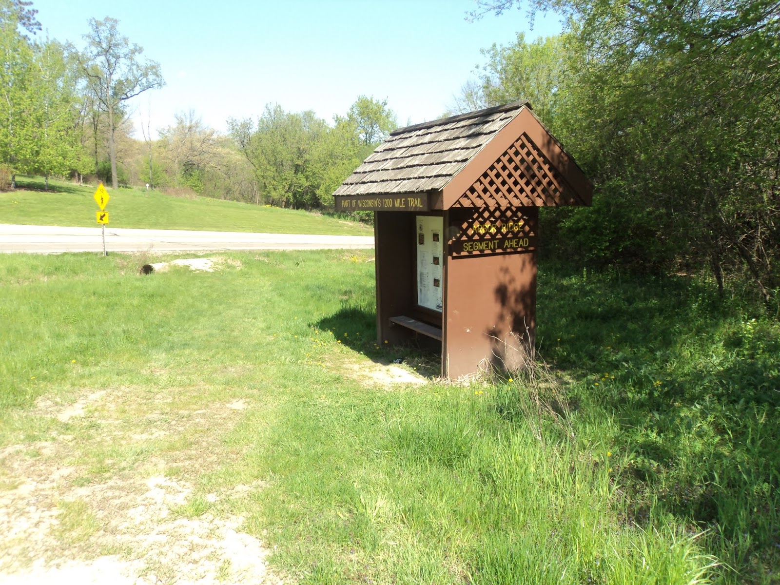
property.  The Center’s main trailhead is located near the southwest corner of the Nature Center building, and 4 trails start here.  This hike starts on the asphalt trail that exits at a soft angle to the left.  This trail forms an oval-shaped loop around a prairie area, and the Center’s Illinois Habitats Trail also starts on this route.
            After walking 1/3 of the way around the oval, turn left to leave the asphalt trail and cross a boardwalk over a wet area.  A grass/mulch trail forms a small loop beside this wetland.  At 0.3 miles, you reach a floating dock that overlooks tranquil Merkle Pond.  I saw a blue heron and several turtles in this pond when I came here on a late afternoon in mid-May.
Merkle Pond
            Continuing around the wetland loop, quickly you reach another asphalt trail, where you need to turn left to continue this hike.  This asphalt trail heads due west and crosses a service road for the Merkle Log Cabin before reaching the Illinois Heritage Grove.  True to its name, the Illinois Heritage Grove is a collection of trees that are native to Illinois.  Interpretive signs help you identify the various trees.
            Exit the grove to the left (south) via a mulch trail.  The mulch trail heads south through a narrow strip of woods with the West Branch of Salt Creek on your right and the Merkle Log Cabin service road on your left.  A boardwalk provides a nice view of the gurgling creek.
West Branch of Salt Creek
            At 0.6 miles, you reach a complicated but well-signed trail intersection.  This hike will eventually turn right to head for the Volkening Heritage Farm, but first turn left and walk a short distance downhill to reach the Merkle Log Cabin.  The cabin and pond are named for Frank Merkle, who purchased this land in the late 1930’s.  The cabin features some high-end log construction, and it occupies a shady scenic spot along the shore of Merkle Pond.  This spot could be in remote northern Michigan or Minnesota were it not for noise from nearby highways and O’Hare airport.
Merkle Log Cabin
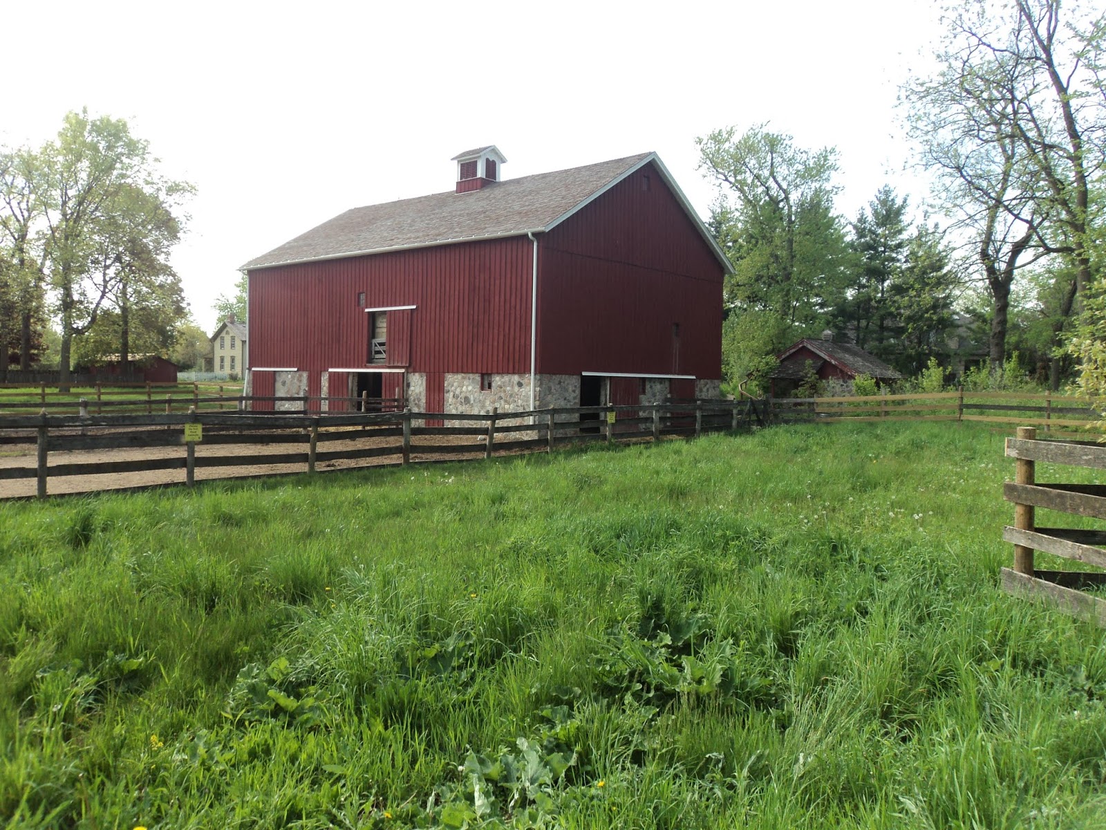
            Back at the complicated trail intersection, continue west to cross Salt Creek and quickly reach the Volkening Heritage Farm.  The farm comes complete with a large red barn, a homestead featuring German-language signage, and live cows.  Walk through the north end of the farm and follow signs for the Plum Grove Road parking area.
Barn at Volkening Heritage Farm

Homestead at Volkening Heritage Farm
            Just past 1 mile, you approach the Plum Grove Road parking area.  Angle left to begin the mulch trail that leads to Bob Link Arboretum.  Virginia bluebells bloomed beside this path on my hike.  At 1.25 miles, you reach Bob Link Arboretum, a grassy area dotted by trees and shrubs.  Turn right to begin the loop around the arboretum.
Bob Link Arboretum
            Stay right where side trails exit left to short-cut the loop, but avoid narrow trails that exit right and lead to private property to the south.  At the east end of the arboretum, turn right to exit the arboretum and head into a large prairie area.  This area was rather dull on my mid-May visit but should feature nice prairie wildflowers in late summer.  Where the dirt trail intersects a paved road, turn right on the paved road to head back to the Schaumburg Road parking area.  The sunny paved road passes a Play Pocket, a small play area for kids that features natural items such as logs and stones, before returning you to the parking area to complete the hike.

Wednesday, May 29, 2019

Ice Age Trail, Arbor Ridge Section and Loop (Blog Hike #742)

Trails: Ice Age and East Boundary Trails
Hike Location: Robert O. Cook Memorial Arboretum
Geographic Location: northwest side of Janesville, WI (42.71520, -89.05369)
Length: 3.6 miles
Difficulty: 5/10 (Moderate)
Date Hiked: May 2019
Overview: A lollipop loop with a mixture of creekside and ridgetop hiking passing an historic log cabin.
Trail Information: https://www.iceagetrail.org/
Hike Route Map: https://www.mappedometer.com/?maproute=748083
Photo Highlight:

Directions to the trailhead: Near Janesville, take I-90 to US 14 (exit 171B).  Exit and go west on US 14.  Drive US 14 west 4.5 miles to Washington Street.  Turn left on Washington St. and drive south 1.3 miles to the signed trailhead parking for the Ice Age Trail on the left.  This gravel parking lot is reached just after passing under a railroad bridge.

The hike: Winding for nearly 1200 miles around central and southern Wisconsin, the Ice Age Trail is one of the nation’s premier long-distance backpacking trails.  The trail is the brainchild of Milwaukee attorney and conservationist Ray Zillmer, and its route roughly traces the furthest advance of glaciers during the most recent ice age, hence the trail’s name.  With 600 miles of trail constructed, the Ice Age Trail is about half complete, and work continues to reroute the remaining segments off of roads and onto dedicated trails.
            Like most long-distance backpacking trails, the Ice Age Trail is divided into segments.  The Ice Age Trail’s Arbor Ridge Segment is featured here.  The relatively gentle Arbor Ridge Segment passes through the Robert O. Cook Memorial Arboretum, which is owned by the City of Janesville and maintained by the Janesville Public School District.  By using some of the arboretum’s trails, you can form a lollipop loop that gives a taste of Ice Age Trail hiking without forcing you to retrace your steps for the entire distance.  Such is the route described here.
Ice Age Trail trailhead
            The Ice Age Trail’s trailhead on Washington St. serves both the Arbor Ridge Segment to the west and the Devil’s Staircase Segment to the east.  The Devil’s Staircase Segment quickly leads to its namesake rock formation along the Rock River, and it is worth exploring if you have more time than I did.  To find the Arbor Ridge Segment, walk northwest across Washington St. to find the wooden post bearing the official Ice Age Trail shield that marks the start of the segment.
Start of the Arbor Ridge Segment
            The mowed grass trail heads northwest with Northridge Drive on the left and a railroad track on the right.  After briefly following the shoulder of Northridge Drive, the trail curves right to head into a narrow strip of woods.  The Ice Age Trail is marked with yellow rectangular paint blazes, and this segment of the trail is very well-marked and well-maintained.  My thanks go to the Ice Age Trail Alliance for building and maintaining such a high-quality track.
            Soon the trail surface changes from mowed grass to single-track dirt, and the railroad track is replaced by a pleasant flowing stream called Marsh Creek that features some nice but small cascades.  After some gentle undulations, at 0.8 miles you enter the arboretum and approach a meadow.  This meadow contains the trail intersection that forms the loop portion of this hike.  The signed East Boundary Trail going left will be our return route.  This hike continues straight to remain on the Ice Age Trail, thus hiking the loop counterclockwise.
Marsh Creek
            On the other side of the meadow, you reach a nice area with benches overlooking a scenic ripple in Marsh Creek.  Next the trail curves left and heads away from the creek by climbing up a wide ravine on a gradual to moderate grade.  Overall, the trail gains just over 150 vertical feet in 0.4 miles.  Metal and wood interpretive signs point out common plants in the forest, which include cottonwood and oak trees.  The trees were just starting to put out leaves on my visit in mid-May, and some redbuds in bloom brightened my path.
Hiking the Ice Age Trail
            Several trails go up this ravine, but you can simplify your route-finding task by just following the Ice Age Trail’s yellow blazes.  As you approach the top of the hill, the arboretum’s amphitheater comes into view through the trees on the right, and the trail passes through an outdoor classroom designed for use by elementary school students.  Some blue aluminum circles nailed to trees mark a short loop that you could add-on if you wanted to extend your hike by a few tenths of a mile.
Just shy of 2 miles, you intersect an asphalt trail as you approach the north end of the arboretum.  We will eventually turn left here, but first look to the right to see a piece of Wisconsin history: the Hornby Log Cabin.  Built in the 1850’s by James Hornby, the cabin was purchased by the Janesville Public School District and moved from its original site in Liberty Pole, WI (a small town in southwest Wisconsin northeast of Prairie du Chien) to here in 2001.  The cabin represents a typical Wisconsin homestead during the period, and some interpretive signs give information about the cabin’s history and the people who built it.
Hornby Log Cabin
The asphalt trail continuing west past the cabin leads to the arboretum parking lot and the end of the Ice Age Trail’s Arbor Ridge Segment.  To continue our loop, leave the Ice Age Trail by heading east on the asphalt trail.  Less than 500 feet later, the asphalt trail ends at a gated intersection with Arbor Ridge Way, a residential street.  Turn left and walk downhill a few hundred feet on Arbor Ridge Way to find the start of the East Boundary Trail, which is marked by a sign and another brown metal gate.
Start of the East Boundary Trail
For its entire 0.7 mile distance the East Boundary Trail follows under a power line as it heads north in a straight line.  Thus, the East Boundary Trail does not make for the most scenic hiking.  On the bright side, this route reduces the retracing of steps, some nice views to the north appear down the power line clearing, and I saw many songbirds including goldfinches in the prairie under the power lines.
Looking down the East Boundary Trail
After a steep descent, you close the loop at 2.8 miles.  Turn right and retrace your steps along the Ice Age Trail 0.8 miles to the Washington St. trailhead to complete the hike.  If you have some more time, check out the Devil’s Staircase Segment of the Ice Age Trail, which starts from this same trailhead but goes the opposite direction from this hike.

Monday, May 27, 2019

Clegg Memorial Garden: Lookout Point and Oak Savanna Trails (Blog Hike #741)

Trails: Lookout Point and Oak Savanna Trails
Hike Location: Clegg Memorial Garden
Geographic Location: east of Lafayette, IN (40.44485, -86.82840)
Length: 0.7 miles
Difficulty: 2/10 (Easy)
Date Hiked: May 2019
Overview: A short lollipop loop passing several blufftop overlooks of Wildcat Creek.
Hike Route Map: https://www.mappedometer.com/?maproute=747923
Photo Highlight:

Directions to the trailhead: Near Lafayette, take I-65 to SR 25 (exit 175).  Exit and go east on SR 25.  Where SR 25 turns right at a traffic circle, take the second exit from the traffic circle to continue straight.  At the next traffic light, turn right on CR 300N.  Drive CR 300N back across SR 25 on a bridge, then immediately turn right on CR 400E.  Drive CR 400E 1.2 miles to the garden.  The garden entrance is on the right, but the parking lot is on the left.

The hike: Owned and maintained by the not-for-profit NICHES Land Trust, tiny Clegg Memorial Garden protects 16.5 acres on the north side of Wildcat Creek.  When it opened to the public in 1965, the property was owned by Harold and Ruth Clegg.  The garden is named for the Clegg’s only son Jerry, who died at an early age.  Ownership was transferred to the NICHES Land Trust in 2014, and the property currently houses NICHES’ administrative offices.
            The garden contains a nice mixture of creekside and blufftop terrain, but it offers no amenities except a small native garden and a short system of hiking trails.  On my visit, the trails along the creek were closed due to erosion problems, so the hike described here features only the two blufftop trails.  While this garden may be too small to be a major hiking destination, it makes a nice contrasting add-on to a Wabash River-side hike at nearby Prophetstown State Park.
Trailhead at NICHES administrative building
            From the parking area, carefully cross CR 400E, walk up the driveway for the NICHES administrative building, then walk around the left side of the building as directed by a sign that says “Trail.”  A trail to Peter’s Mill and Wildcat Creek exiting left was closed on my visit.  The Lookout Point Trail immediately begins descending wooden steps to reach the first of three wooden observation platforms.  This platform contains a bench and overlooks a nice patch of forest but no points of interest.
            More wooden steps drop you deeper into the ravine, and the ravine’s stream is crossed on a wooden bridge.  Notice some stone steps that exit left here; they lead to a rough trail that follows this creekbed down to Wildcat Creek.  Our trail embarks on a sidehill course as it climbs gradually to reach Lookout Point at 0.15 miles.  Lookout Point is another wooden observation platform, but trees largely block the view of Wildcat Creek during the warmer months.
Climbing toward Lookout Point
            Just past Lookout Point, the trail forks to form the Oak Savanna Loop Trail.  A post labeled as Node 3 marks this point.  To get to the best view of Wildcat Creek quickly, this description turns left here and uses the right trail as its return route, thus hiking the loop clockwise.  The maple, beech, and hickory trees that dominated the ravine are now replaced by oaks in this sunnier and drier landscape.  Large numbers of wildflowers including Virginia bluebells and nodding onion were in bloom on my visit.
Virginia bluebells in bloom
            Quickly you reach the third and final observation platform.  This platform gives the best blufftop view of Wildcat Creek, which was high and muddy when I hiked here.  Exit the platform by taking the trail closest to the edge of the bluff; a gravel trail that heads uphill provides an opportunity to short-cut the loop.
Wildcat Creek, as seen from 3rd observation platform
            At 0.25 miles, the Wildcat Creek Trail (as I mentioned before, closed on my visit) enters from the left.  The trail curves right and climbs slightly while passing several benches to reach a major trail intersection.  Angle left to stay on the Oak Savanna Loop Trail.  Private property comes very close on the left before the trail curves right to tread along the rim of the ravine you hiked through earlier.  Just past 0.5 miles, you close the loop.  Angle right and retrace your steps to the parking lot to complete the hike.

Friday, May 24, 2019

Big Ridge State Park: Lake/Dark Hollow/Ghost House Loop (Blog Hike #740)

Trails: Lake, Dark Hollow, Big Valley, and Ghost House Trails
Hike Location: Big Ridge State Park
Geographic Location: west of Maynardville, TN (36.24368, -83.93093)
Length: 5.9 miles
Difficulty: 8/10 (Moderate/Difficult)
Date Hiked: May 2019
Overview: A lollipop loop passing many old settlement sites.
Photo Highlight:
Hike Video: 

Directions to the trailhead: North of Knoxville, take I-75 to SR 61 (exit 121).  Exit and go east on SR 61.  Drive SR 61 east 12 miles to the signed entrance for Big Ridge State Park on the left.  Turn left to enter the park, then turn left to reach the Visitor Center and park office.  Park in the parking lot at the start of the campground road just past the park office.

The hike: Established in the 1930’s by the Tennessee Valley Authority (TVA) as one of five demonstration parks, Big Ridge State Park protects 3687 acres on the south shore of Norris Lake.  The park was built in cooperation with the National Park Service and the Civilian Conservation Corps (CCC), and many of the park’s buildings still feature the CCC’s handiwork.  Prior to the TVA’s arrival, pioneer settlers scratched out a meager living on this land, and remnants of their presence dot the park’s landscape.  Several of these remnants are passed on this hike.
            Big Ridge State Park offers many nice amenities, including swimming, fishing, and boating on Big Ridge Lake, 20 cabins, a 50-site campground, and several picnic areas.  Of the three state parks north of Knoxville with TVA roots (Norris Dam and Cove Lake being the other two), Big Ridge is the best destination for hikers as it features over 15 miles of hiker-only trails.  Many routes through the park’s trail system are possible, and the route described here gives a good sample of the area’s landscape without pegging the difficulty meter.
Trailhead along campground road
            From the start of the campground road, walk toward the campground to find the signed trailhead for the Lake Trail on the right.  Trails at Big Ridge State Park are marked by color-coded plastic shields; the shields on the Lake Trail are green.  Though not particularly numerous, the markings are sufficient to keep you on the trail.  The single track dirt Lake Trail climbs moderately for a short distance with Big Ridge Lake visible through the trees downhill to the right.  Sweet gum, maple, and beech are the most common trees in this forest, but some loblolly pines planted by the CCC in the 1930’s also enter the mix.
            Two short spur trails exit the Lake Trail: the Meditation Point Trail to the right at 0.1 miles and the Loyston Overlook Trail to the left at 0.5 miles.  The Meditation Point Trail leads a short distance uphill to a bench in the middle of the forest, while the Loyston Overlook Trail leads a slightly longer distance uphill to an overlook of Norris Lake.  These spur trails are worth exploring either now or on your journey back to the trailhead after you complete the loop portion of this hike.
Meditation Point
            After passing a bench and shelter just past the Lake Trail’s highest elevation, the trail descends gradually to reach the west side of Big Ridge Dam at 0.6 miles.  A 50-foot concrete dam built by the CCC, Big Ridge Dam separates the park’s Big Ridge Lake on the right from the much larger Norris Lake on the left.  The dam allows water levels in the park’s lake to remain constant despite seasonal changes in Norris Lake’s water level.  When I came here in late spring, water levels in the two lakes were about the same.
Big Ridge Dam
            The Lake Trail crosses Big Ridge Dam to reach the trail intersection that forms the loop portion of this hike.  The Lake Trail continues to the right, and it will be our return route.  To hike the steepest sections downhill, this description turns left to begin the Dark Hollow Trail, thus hiking the loop clockwise.
            Marked with blue plastic shields, the Dark Hollow Trail is narrower and more primitive than the Lake Trail.  The initial segment of the Dark Hollow Trail clings to the side of Pinnacle Ridge with Norris Lake just downhill to the left.  Several downed trees will need to be negotiated.  Some poison ivy grows along this trail, but careful looking for leaves of three will allow you to avoid it.
Dark Hollow Trail along Lake Norris

Lake Norris
The trail passes an unofficial campsite as it climbs up and over the end of Pinnacle Ridge before descending into West Dark Hollow.  Dark Hollow is a deep east-west ravine that lies between the park’s namesake Big Ridge to the north and the lower Pinnacle Ridge to the south.  A low saddle in the middle separates the hollow into east and west parts.
            At 1.4 miles, you cross a nice wooden footbridge over the main stream in Dark Hollow before turning right to begin heading up the hollow.  Soon you pass signed official backcountry campsite #1, which occupies a pleasant location just uphill from the creek.  For the next mile the trail follows an old dirt road as it climbs gradually up West Dark Hollow.  You pass several old homestead sites; they are identified by stone foundations, flat areas, and/or plants such as red cedars and daffodils.  Though the name Dark Hollow sounds ominous, the hiking is quite pleasant.
Hiking up Dark Hollow
            At 2.4 miles, you climb a gradual broad switchback to reach the saddle in the middle of Dark Hollow and an intersection with the Big Valley Trail, which goes left and right.  Turning left leads to the Indian Rock Loop, a very scenic but also very long and difficult add-on to this hike.  This description turns right to begin heading back toward the trailhead.
            Marked with orange plastic shields, the Big Valley Trail climbs rather steeply on an eroded track to reach the highest elevation on this hike, which stands about 350 feet above Big Ridge Lake.  A steep descent next brings you to the upper end of the Ghost House Trail at 3.2 miles.  You could go either way here, but to see more old settlement remnants this description turns right here and then turns left at the next intersection to descend gradually along the east arm of the Ghost House Trail’s loop, which is marked with yellow plastic shields.
The "ghost house"
            Soon you reach the “ghost house” for which this trail is named.  Once the home of Maston Hutcheson’s grandson, all that remains is a root cellar, cistern, and well casing.  Local legend states that this structure and the nearby Hutcheson family home are haunted, but I encountered no paranormal activity on my visit.
Norton cemetery
            Just past the ghost house lies the Norton cemetery, a pioneer cemetery that features headstones dating to the early 1900’s.  More gradual descending brings you to the lower end of the Ghost House Trail, where a left turn brings you to an intersection with the Lake Trail at 4.1 miles.  Turn right to begin the last segment of this hike.
            This part of the Lake Trail can be rather muddy, but it offers only minor undulations with persistent views of Big Ridge Lake to the left.  At 4.5 miles, a spur trail heads a short distance right to reach the Snodderly-Armp cemetery.  The headstones in this pioneer cemetery are older than the ones in the Norton cemetery you passed earlier, and this cemetery contains the burial sites of some of this area’s earliest residents.
Snodderly-Armp cemetery
            5.3 miles into the hike, you close the loop at the east end of Big Ridge Dam.  Cross the dam and retrace your steps to the trailhead to complete the hike, making sure to take the spur trails to Loyston Overlook and/or Meditation Point if you did not visit these places earlier.  Also, on your drive back out to I-75, you will pass the Museum of Appalachia, which features a recreated pioneer village that depicts life in this region during the early 1900’s.  After hiking past what remains of these old settlement sites, you can stop at the museum on your way home to see what the sites might have looked like at their peak.