Friday, June 23, 2017

Cherokee National Forest, Ocoee Whitewater Center: Old Copper Road Trail (Blog Hike #640)

Trail: Old Copper Road Trail
Hike Location: Cherokee National Forest, Ocoee Whitewater Center
Geographic Location: west of Ducktown, TN (35.06924, -84.46623)
Length: 5.4 miles
Difficulty: 3/10 (Easy/Moderate)
Date Hiked: June 2017
Overview: An out-and-back along the north bank of the Ocoee River.
Photo Highlight:
Hike Video: 

Directions to the trailhead: The Ocoee Whitewater Center is located on the south side of US 64/74 6 miles west of Ducktown.  The parking around the center’s main building is 30-minute gift shop parking, so you need to park in the large day-use parking lot just downriver.  Park as close as possible to the lower wooden bridge over the Ocoee River because the hike begins and ends there.

The hike: Located on the main road heading east out of Cleveland, the Ocoee Whitewater Center was built for the canoe/kayak slalom events at the 1996 Olympic Games hosted by Atlanta, GA.  The Center has the distinction of being the only Olympic whitewater course to be located on a natural river, the Ocoee River.  The portion of the river used for the Olympics was modified to build a suitable whitewater course, and on many summer weekends water is released from a dam upstream to create whitewater conditions.
            The Ocoee Whitewater Center today serves as a Visitor Center for Cherokee National Forest, Tennessee’s only national forest, and as a trailhead for many hiking and mountain biking trails.  One of the area’s most popular trails is the Old Copper Road Trail described here.  Under the lead of John Caldwell, the Old Copper Road was built in 1853 to connect the copper mines of extreme southeastern Tennessee with the railroad terminus in Cleveland.  Teams of oxen would take 2 days to make the journey one-way.  Today modern vehicles make roughly the same journey in about 45 minutes on US 64/74.
            Three other preliminary notes need to be mentioned.  First, the trail distance I give here differs from the 4.6 mile distance given by the forest service.  The forest service measures from the Old Copper Road Trail’s trailhead at the upper end of the Ocoee Whitewater Center, but to reach the trailhead you have to hike 0.4 miles through the Olympic whitewater area.  Thus, the mileage difference is due to the distance through the Whitewater Center.  Second, you could do this hike as a two-car shuttle by leaving one car at the upper end of the Old Copper Road Trail, which is located at the private boater put-in on FR 334.  Third, because this trail is open to mountain bikers and because of the water release schedule, I recommend that you avoid this area on summer weekends.  I came here on a Thursday in mid-June, saw two other trail users (both bikers), and had a nice hike.
Start of concrete riverside trail
            With the preliminaries out of the way, let’s get hiking!  Start with a walk through the Olympic whitewater course, which is accessed by a concrete riverside trail that starts just below the lower bridge over the Ocoee River.  A sign warns you to beware of rising water levels.  Indeed, this trail stays close enough to the river to make it underwater during a sufficiently large water release.  Sirens and flashing lights warn of impending water releases, so you need to get off of this trail by any means necessary if the sirens sound.
Olympic whitewater area
            The concrete trail heads up the Ocoee River’s north bank.  Notice the large number of small boulders along the river’s bank and the unusually-shaped rocks in the river’s channel, and file this look in your memory for later use.  After crossing Rock Creek on a footbridge, the trail curves right along with the river as the Ocoee Whitewater Center’s main building comes in sight.  The two-story red-roofed building contains restrooms with flush toilets, a small gift shop, and a staffed information desk with trail maps.
Ocoee Whitewater Center
            Stay to the right of the main building to arrive at the Center’s upper bridge across the Ocoee River.  Just past this bridge lies the trailhead for the Old Copper Road Trail (Cherokee National Forest Trail #306).  The trail drops steeply but only for a short distance to return to river level and begin heading upstream.  The trail surface starts as concrete but soon turns first to gravel and then to dirt.  Some strategically placed stepping stones get you over Laurel Creek with mostly dry feet.
Start of Old Copper Road Trail
            0.8 miles into the hike (or 0.4 miles into the Old Copper Road Trail), you reach an 
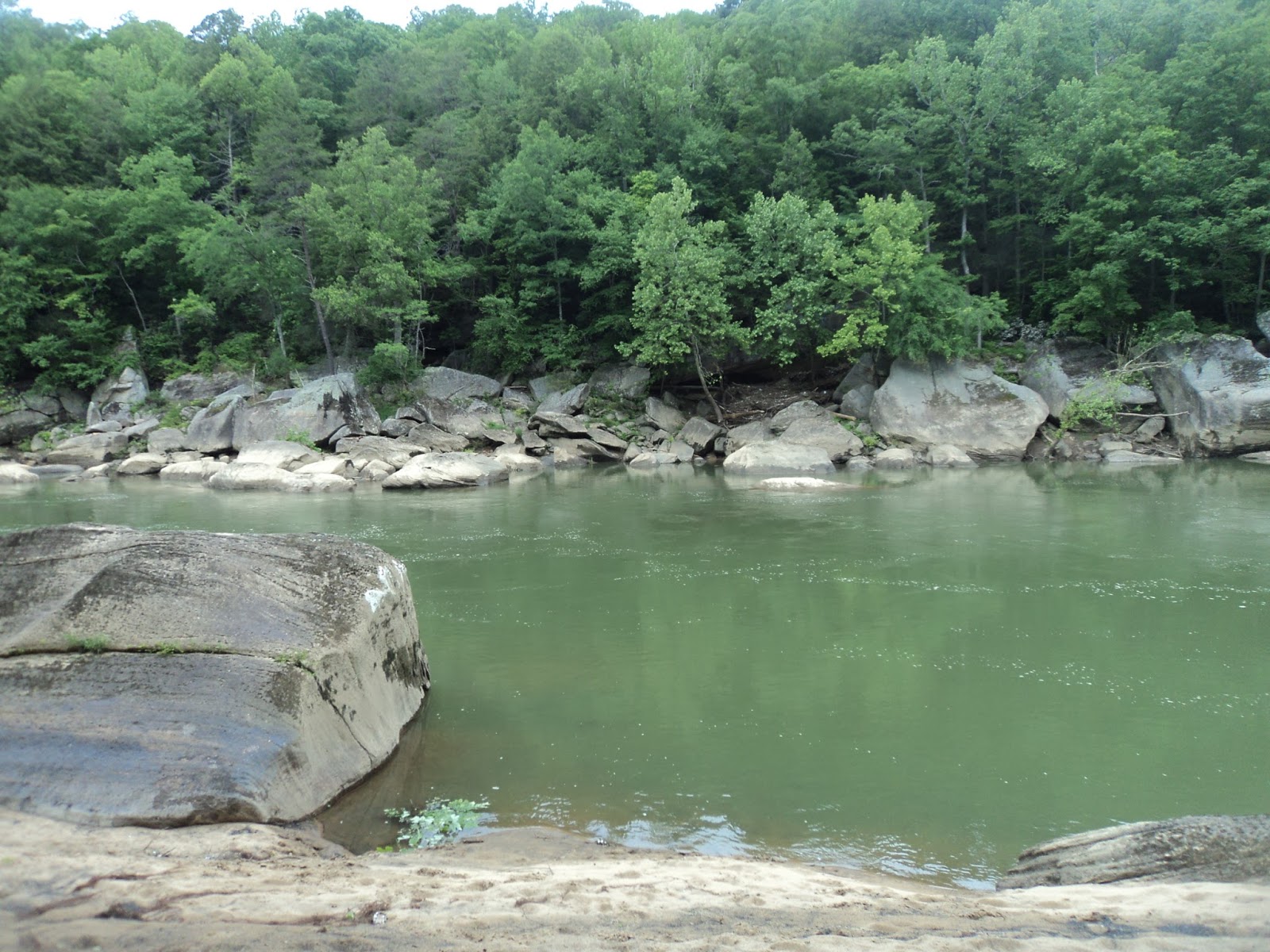
opening on the right that gives a nice river view.  This area marks the upper end of the constructed whitewater area, and notice how different the river upstream to your left looks compared to the Olympic whitewater area you walked through earlier.  Some rhododendron was just starting to bloom on my mid-June hike.
Upper end of whitewater course
            Continuing upstream, the road noise from US 64/74 disappears uphill to the left as the highway and river part ways.  The Old Copper Road Trail is marked with a few purple i-shaped paint blazes, but the trail is wide and easy to follow.  Each mile is also marked with a sign.  Soon you pass a couple of rock outcrops on the left.  A rattlesnake startled me as it slithered off the trail and into one of these outcrops. 
At 1.4 miles, you cross a wooden replica of the 1841 Howe Thru Truss Bridge that carried the original Old Copper Road across this creek.  Some ferns and sweet gums appear among the flora as you continue upstream, and more small streams are crossed via wooden footbridges.  These streams make nice cascading sounds as they approach their confluence with the Ocoee.  Most of this hike is shaded, but some sunnier areas are encountered as you head further upstream.
Hiking along the Ocoee
Just past the 2 mile marker, you pass a poorly maintained observation/contemplation area on the right.  After climbing slightly to reach the highest point on this hike, a gradual descent brings you to the private boater put-in on FR 334.  A restroom building and some picnic tables also stand here.  The Old Copper Road Trail ends at the put-in, so after a brief rest and trail snack you need to retrace your steps back to the Ocoee Whitewater Center.
To add a little variety, instead of walking the concrete path along the river below the Center’s main building, cross the upper bridge and walk the last segment back to your car along the river’s south bank.  Just before you walk across the lower bridge to return to the parking area, note the Rhododendron Trail on the left.  The Rhododendron Trail is a 1 mile one-way trail that offers a hike similar to this one but shorter and on the other side of the river.

Wednesday, June 21, 2017

Sumter National Forest: Big Bend Trail to Big Bend Falls (Blog Hike #639)

Trails: Big Bend and Chattooga River Trails
Hike Location: Sumter National Forest
Geographic Location: northwest of Walhalla, SC (34.94133, -83.08988)
Length: 6.6 miles
Difficulty: 6/10 (Moderate)
Date Hiked: June 2017
Overview: An out-and-back to the Chattooga River and powerful Big Bend Falls.
Hike Route Map: https://www.mappedometer.com/?maproute=733046
Photo Highlight:

Directions to the trailhead: From Walhalla, take SR 28 west 8.2 miles to SR 107 and turn softly right on SR 107.  Drive SR 107 north 8.5 miles to an unsigned gravel pullout on the right that serves as the trailhead parking area.  The easiest way to find this pullout is to drive to Sumter National Forest’s signed Cherry Hill Recreation Area and backtrack about 500 feet.  The trail starts on the opposite side of the road from the pullout.

The hike: Cutting a 57-mile gouge along the Georgia/South Carolina border, the Chattooga River is one of the southeast’s longest free-flowing rivers.  The Chattooga rises near Cashiers, NC and flows roughly southward over many roaring rapids before ending with a whimper at the backwaters of Lake Tugaloo.  The river’s most famous moment came in 1972 when scenes from the movie Deliverance were filmed along its banks and in its rapids.  In 1974, the Chattooga was designated a National Wild and Scenic River, thus making it the first river east of the Mississippi to receive this designation.
            For most of its distance the Chattooga River’s west bank lies in Georgia’s Chattahoochee National Forest while its east bank lies in South Carolina’s Sumter National Forest.  Thus, large segments of the river are preserved in their natural state.  The hike described here does not provide the shortest or easiest Chattoga River access, but it takes you to a secluded section of the river (several miles to road access in either direction) and to Big Bend Falls, a major river waterfall.
Big Bend Trail trailhead
            The Big Bend Trail starts on the west side of SR 107 across from the gravel pullout described in the Directions to the trailhead.  The first of the Big Bend Trail’s many powder blue paint blazes marks this point, as does a warning sign stating that the trail is open only to foot travel.  A wooden sign with trail mileages also stands here, but it is located a few feet into the woods and may be harder to see.
Cascade in Cane Creek
            The trail descends moderately to reach the bank of Crane Creek, which contains some small cascades.  The cascades make great audio, but dense rhododendron makes them hard to see.  After crossing the creek on a nice wooden footbridge, the trail curves right to climb gradually away from Crane Creek.  A double powder blue blaze (two blazes on a single tree) marks this turn.  Although the trail had been cleared recently on my visit, the trail’s narrowness and lack of traffic may require you to watch the blazes to stay on the trail.
Over the next 0.7 miles the trail gains 130 feet of elevation on a grade that is mostly imperceptible.  Along the way you pass in and out of numerous ravines, all of which feed into unseen Pigpen Branch.  Gravel and seldom-used Big Bend Road (FR 709) roughly parallels this trail, and occasionally it comes into view on the right.  The entire trail passes through broadleaf forest with tulip poplars being the largest trees in the forest.
Hiking the Big Bend Trail
Near 1 mile into the hike, you reach the hike’s highest point as you round one of many finger ridges.  The next 1.6 miles are a gradual descent that loses about 250 feet of elevation in fits and starts.  A few wooden steps improved footing in the past, but they are partly overgrown now.  Three side trails branch off from the road uphill to your right and cross your path.  The dull roar of the distant Chattooga River will be one of the few sounds you hear in this area.
At 2.3 miles, the trail curves left as it drops into the ravine that will bring you to the Chattooga River.  After crossing the ravine’s stream twice in quick succession, a creekside descent brings you to the Big Bend Trail’s western end and a junction with the combined Foothills and Chattooga River Trails, which go right and straight.  A national recreation trail marker also sits here.  Continue straight to begin hiking southbound on the Chattooga River Trail.
Intersecting the Chattooga River Trail
The green blazes of the Chattooga River Trail and the white blazes of the Foothills Trail run conjointly along this section of trail.  After crossing a steep angler’s trail that comes downhill from the end of Big Bend Road, the Chattooga River comes into sight for the first time.  The trail descends a pair of switchbacks to reach a charming riverside campsite right below a big rapid in the river.  The site makes a great place to stop, have a trail snack, and enjoy the sights and sounds along this secluded slice of river paradise.
Chattooga River above Big Bend Falls
Some people think this rapid is Big Bend Falls, but in fact the falls lie further downstream.  Continuing south on the Chattooga River Trail, the trail climbs a bluff before descending another pair of switchbacks.  Due to the rugged terrain and dense rhododendron, Big Bend Falls is more easily heard than seen.  The steep unsigned spur trail to Big Bend Falls exits right at the base of some rock steps just after the second switchback.  The waterfall is only 30 feet high, and it falls in numerous stages.  Nevertheless the river’s large water volume makes Big Bend Falls a powerful sight.  After viewing (or perhaps only hearing) Big Bend Falls, retrace your steps 3.3 miles to the trailhead to complete the hike.

Saturday, June 17, 2017

Cumberland Falls State Resort Park: CCC/Sheltowee Trace/Rock House Loop (Blog Hike #638)

Trails: CCC, Sheltowee Trace, and Rock House Trails
Hike Location: Cumberland Falls State Resort Park
Geographic Location: southwest of Corbin, KY (36.83891, -84.33832)
Length: 2.7 miles
Difficulty: 6/10 (Moderate)
Dates Hiked: May 2017, June 2020
Overview: A loop hike using the Sheltowee Trace and passing impressive Cumberland Falls.
Photo Highlight:
Hike Video: 

Directions to the trailhead: In southern Kentucky, take I-75 to US 25W (exit 18 or 25, depending on whether you are going north or south on I-75).  Exit and take US 25W 3 miles north from exit 18 or 3 miles south from exit 25 to SR 90.  Go west on SR 90.  Park at the state park’s DuPont Lodge, which is located on the left 7.4 miles west of US 25W.

The hike: Often called the “Niagara of the South,” Cumberland Falls has been attracting visitors for centuries.  The first European-born person to see the falls was Dr. Thomas Walker, who in 1750 named the river and waterfall after the Duke of Cumberland, a son of England’s King George II.  Ownership of the falls changed several times until 1927, when T. Coleman DuPont offered to buy the falls and donate it to the Commonwealth of Kentucky for the creation of a state park.  Cumberland Falls State Park was officially dedicated in 1931, thus making this area one of the oldest state parks in a state with a rich history of parks and conservation.
            While the falls remains the park’s main attraction, Cumberland Falls State Park offers several nice amenities, including an historic 51-room lodge, a cozy 50-site campground, a picnic area, a swimming pool, a gift shop near the falls area, and 17 miles of hiking trails.  The hiking route suggested here passes through the congested falls area, but it has several advantages over other possible routes.  First, the hike starts at DuPont Lodge, where you are likely to be able to find a parking spot.  Second, this route takes some of the park’s lesser-used trails to get to the falls, so trail traffic is usually quite low except at the always-crowded falls area.  Third, this hike spends significant time on the Sheltowee Trace, Kentucky’s best long-distance backpacking trail.
            On a personal note, my family has taken several trips to Cumberland FallsCumberland Falls is a regionally popular honeymoon destination, and in July 1972 my parents came here on their honeymoon.  I brought my mom back here in 2004, but I did not get to do any significant hiking at Cumberland Falls until the last day of my May 2017 Kentucky hiking trip.  I had intended to hike the Eagle Falls Trail on the more secluded west side of Cumberland Falls, but the overflowing parking lot at that trailhead caused me to choose this hike instead.
Start of Trail #4 beside lodge
            The hike begins on the Civilian Conservation Corps Memorial Trail (Trail #4), which starts at a wooden post and information kiosk on the front left side of DuPont Lodge.  The depression-era Civilian Conservation Corps (CCC) built many of the park’s original facilities and trails, including some stone steps that are still used by this trail today.  Trails at Cumberland Falls State Resort Park are identified by both name and number, and they are marked with yellow paint blazes that also contain the trail’s number.
The trail heads northeast with a vertical sandstone cliff separating you from the park’s cottage area uphill to the left.  The CCC built some tool storage compartments into these cliffs, and some interpretive signs point them out for you to see today.  Large amounts of American holly grow under this cliff line.
CCC storage compartment in cliffs
            At 0.4 miles, the trail curves sharply right as you cross one of the park’s horse trails twice in quick succession.  Camper’s Path (Trail #5) also exits left here; it leads 0.5 miles to the park’s Ridgeline Campground.  The terrain’s relief lessens as you begin heading southwest on a course that is almost parallel to but downhill from the path you hiked earlier.  At 0.6 miles, a nice view of the back of DuPont Lodge appears uphill to the right.
Back of DuPont Lodge
            After a spur trail to the lodge exits right, you descend another long set of CCC-built stone steps.  At 0.75 miles, you intersect the Cumberland River Trail (Trail #2) as the Cliffside Picnic Area comes into view downhill and the Cumberland River comes within earshot just beyond the picnic area.  To keep heading for Cumberland Falls, you need to turn right here.
            Soon you learn why this picnic area is called the Cliffside Picnic Area, as Trails #2 and #4 run conjointly along the base of a tall vertical sandstone cliff.  This cliff also features a nice rock shelter and, if it has rained recently, a low-volume waterfall.  After descending a single switchback, Trails #2 and #4 end at an intersection with the picnic area access road.  Turn right to head out of the picnic area, but first go down to the river to view the Edward Moss Gatliff Bridge.  Built in 1954, this stone bridge with graceful arches gives SR 90 motorists safe passage over the Cumberland River.
Gatliff Bridge
            After exiting the picnic area, carefully cross SR 90 to reach the huge parking lot for Cumberland Falls.  Instead of walking through the parking lot, angle right to pick up the Sheltowee Trace (Trail #1), which is marked by turtle-shaped blazes and an official-looking national recreation trail marker.  The Sheltowee Trace stays within a narrow strip of trees between the parking lot to the left and SR 90 to the right.  The Cumberland Falls Trail (Trail #6) soon enters from the right.
            At 1.2 miles, you reach the Cumberland Falls Visitor’s Center and Gift Shop.  Just past these buildings lie the falls itself.  The first viewpoint offers a top-side view from a rocky outcrop, but some concrete steps lead down to the postcard view from beside the outcrop.  At 65 feet high and 125 feet wide, this roaring river waterfall is a real sight to behold.  Cumberland Falls is one of only two waterfalls in the world to produce a moonbow (a rainbow created by light from the moon) with its mist, but you will have to come at the right time of night during a full moon to see it.  Take some time to enjoy this magnificent sight.
Cumberland Falls
            The shortest route back to the lodge is Trail #6, but to see some more of the Cumberland River and more rock outcrops, exit the falls area by continuing north on the Sheltowee Trace, which is also called the Moonbow Trail in this area.  The trail climbs moderately and crosses some small streams on wooden footbridges.  Many of the bridges in this park have roof shingles nailed to their floors to provide traction.  Twice the Wildflower Loop Trail (Trail #12) exits right and offers an opportunity to short-cut this hike.  Stay left to remain on the Sheltowee Trace.
Cumberland River below the falls
            The trail descends some steep wooden steps to return to a riverside course.  The next 0.4 miles feature a decent amount of up-and-down as the trail parallels the river, heading downstream.  Overall, the terrain is rather rocky and the going quite slow.  Near 2 miles into the hike, you reach a recent trail reroute.  The trail now turns right to head uphill to a large rock house with a low-volume seasonal waterfall.
Rock house on Rock House Trail
            The trail curves left to climb above the rock house via a more gradual set of wooden steps.  At 2.1 miles, you reach a junction with the Rock House Trail (Trail #7).  The Rock House Trail is the last trail that heads back to the lodge, so you need to turn right to leave the Sheltowee Trace and begin the Rock House Trail.
            The Rock House Trail climbs gradually along the base of another cliff.  After climbing another short set of steps, the Anvil Branch Trail (Trail #11) exits left.  Continue straight to remain on the Rock House Trail, which soon ends at the Wildflower Loop Trail (Trail #12).  Turn left on the Wildflower Loop Trail.
Climbing on Wildflower Loop Trail
            The Wildflower Loop Trail climbs moderately to enter the Clifty Campground at 2.5 miles.  To get back to the lodge, turn left and walk the main campground road out to SR 90.  Turn right on SR 90 and walk along the road’s wide shoulder to reach the lodge at 2.7 miles and complete the hike.

Wednesday, June 14, 2017

Bernheim Arboretum and Research Forest: Lake Nevin and Sun & Shade Loops (Blog Hike #637)

Trails: Lake Nevin and Sun & Shade Loops
Hike Location: Bernheim Arboretum and Research Forest
Geographic Location: south of Shepherdsville, KY (37.91845, -85.66876)
Length: 2 miles
Difficulty: 2/10 (Easy)
Date Hiked: May 2017
Overview: A pair of loops, mostly through a sunny arboretum.
Area Information: https://bernheim.org/
Hike Route Map: http://www.mappedometer.com/?maproute=613668
Photo Highlight:

Directions to the trailhead: South of Louisville, take I-65 to SR 245 (exit 112).  Exit and go east on SR 245.  Drive SR 245 east 0.9 miles to the signed arboretum entrance on the right.  Turn right to enter the arboretum, pass the gatehouse, and bear right at the first intersection.  Where the road becomes one-way (against you), turn right to park in the Garden Pavilion parking lot, where this hike begins.

The hike: Located on the south side of the Louisville metro area, Bernheim Arboretum and Research Forest is the legacy of Isaac W. Bernheim.  Bernheim emigrated from Germany to Kentucky in 1867 with $4 in his pocket, and he made his fortune by establishing the I.W. Harper brand of whiskey.  In 1928, Bernheim purchased 14,000 acres of strip-mined land south of Louisville for $1 per acre.  The Frederick Law Olmsted landscape architecture firm started work on designing the arboretum in 1931, and the site opened to the public in 1950.
            As its name suggests, Bernheim Arboretum and Research Forest is divided into two parts: a manicured arboretum and a natural area research forest.  The area is a paradise for hikers, as 35 miles of trails offer something for every ability and interest.  The site’s signature hike is the 13.75 mile Millennium Trail, which gets its name because it opened at the start of the new millennium.  I had intended to do a hike in the forest section, but the helpful man at the Visitor Center suggested I hike in the arboretum due to some heavy rainfall the previous day.  Thus, this hike describes two of the shorter trails in the arboretum, and it is designed to whet your appetite for the hiking Bernheim has to offer.
Trailhead: Lake Nevin Loop
            Start at the right (north) side of the Garden Pavilion parking lot where a tall information kiosk announces the start of the Lake Nevin Loop.  Most of the Lake Nevin Loop is exposed to the sun, so this hike will be hot and sunny during the summer.  The wide gravel trail heads north through a mowed-grass area with the lake on your left.  The arboretum features several sculptures, some of which sit near the trail, and signs help you identify the arboretum’s trees and shrubs.  A large flock of Canada geese were poking around in a wet area looking for a meal on my visit.
Canada geese
            As you round the north end of Lake Nevin, ignore the Green Path that exits right and leads to the arboretum’s maple and crabapple collections.  Now heading south, you cross the concrete bridge over the lake’s spillway at 0.5 miles.  The mowed-grass surroundings change to a nice tallgrass prairie after you cross the spillway.  Large numbers of butterflies and dragonflies were flittering around this area on my hike. 
Lake Nevin
            At 0.8 miles, the trail curves left to cross two of the lake’s feeder streams on wooden footbridges.  In between the two creeks, you pass Sunset Amphitheater, which has a nice lakeside setting.  Immediately after crossing the second bridge, look for the narrow, dirt Sun and Shade Loop exiting right.  There is a sign for the Sun and Shade Loop here, but it is sufficiently surrounded by dense green understory that you need to be looking for it to find it.  Turn right to begin the Sun and Shade Loop.
            Marked with red plastic triangles, the “shade” half of the Sun and Shade Loop provides the closest thing to a nature trail on this hike, as the narrow dirt trail passes through older growth forest.  After crossing a small creek on a wooden footbridge, the trail climbs steeply but only for a short distance.  Near the top of this hill, some interesting moss-covered boulders sit beside the trail.
Moss-covered boulders
            The trail curves left and descends gently as it passes through the upper reaches of a ravine.  Next, you exit the forest to reenter the arboretum and begin the “sun” half of the Sun and Shade Loop.  The main arboretum road comes very close on the right before the trail descends slightly to return to the Lake Nevin Loop.  Turn softly right to continue the Lake Nevin Loop.  The trail surface briefly turns to asphalt as you approach the Lakeside Studio.  After curving right, a gentle ascent brings you back to the Garden Pavilion parking lot to complete the hike.

Sunday, June 11, 2017

Charlestown State Park: Trails #3 and #7 (Blog Hike #636)

Trails: Trails #3 and #7
Hike Location: Charlestown State Park
Geographic Location: north side of Charlestown, IN (38.42706, -85.62971)
Length: 3 miles
Difficulty: 5/10 (Moderate)
Date Hiked: May 2017
Overview: A semi-loop featuring the historic Portersville Bridge and the site of the former Rose Island Amusement Park.
Photo Highlight:
Hike Video: 

Directions to the trailhead: On the Indiana side of the Louisville metro area, take SR 265 (the eastward extension of I-265) to SR 62.  Exit and go east on SR 62. Drive SR 62 east 8 miles to the signed state park entrance on the right.  Turn right to enter the park, pay the large state park entrance fee, and follow the main park road for 2.1 miles to the signed turn-off for Trail #3 on the left.  Turn left on the trailhead access road, which deadends at the parking lot for Trail #3 0.5 miles later.

The hike: If you drive to Charlestown State Park from Louisville using the directions above, the industrial parks and empty buildings you drive past just outside the park entrance hold little promise for a good hike, but early indications can be deceiving.  The area’s industrial look stems from the fact that the Indiana Army Ammunition Plant operated here from 1940 until 1995.  The site was chosen due to its central location far from any national borders, and the plant made propellant for rockets and other weapons.  Some abandoned railcars still sit near the trailhead parking area, and plant clean-up continued on adjacent land as recently as 2014.
            When the plant closed in 1995, 6000 acres of its land were transferred to local groups for development as an industrial park, and 4500 acres were transferred to the State of Indiana to create this park.  Charlestown State Park opened in 1996, making it one of Indiana’s newest state parks.  Development of the park continues today, but the park already features several picnic shelters, a modern 192-site campground, and fishing and boating access to the Ohio River.
            For hikers, the park offers 7 trails totaling over 13 miles.  While the park’s youth ensures that no walks through pristine old growth forest will be had here, several of the park’s trails explore the steep ravine that contains Fourteenmile Creek, a minor tributary of the Ohio River.  This hike follows the park’s most popular and perhaps most scenic trails, and it explores not only Fourteenmile Creek’s ravine and the Ohio River but also the historic Portersville Bridge and the site of historic Rose Island, an amusement park that operated here in the early 1900’s.
Start of Trail #3
            Trails #3 and #4 both start at this trailhead, so you should choose the paved trail curving right to begin Trail #3.  Less than 200 feet later, Trail #3 splits to form its loop where an unsigned grassy trail exits left.  To get to Rose Island faster, this hike stays right to remain on the asphalt trail, thus hiking Trail #3’s loop counterclockwise.
            The smooth asphalt trail heads southeast and soon begins a steep descent into Fourteenmile Creek’s ravine.  The difference in elevation between the trailhead and Fourteenmile Creek is about 250 feet.  The trail is wide enough to be a one-lane road, and it is also used by park vans to provide ADA-access to Rose Island.
Box turtle on the trail
            At the bottom of the hill, the trail curves sharply left to reach the historic Portersville Bridge.  Trail #3 continues as a dirt trail to the left, but before going that way cross the bridge to hike Trail #7, the 0.9 mile trail that explores the Rose Island amusement park site.  Built in 1912, the Portersville Bridge originally spanned the East Fork of the White River near Portersville, IN some 100 miles west of here.  The bridge carried vehicle traffic for 86 years before being closed, disassembled, cleaned, moved to this location, and reassembled.  Today the bridge carries only foot traffic and gives park visitors safe passage over Fourteenmile Creek to the Rose Island amusement park site. 
Portersville Bridge
            On the far (east) side of the bridge, Trail #7 splits to form its loop.  I again turned right to hike the loop counterclockwise.  The main gravel trail follows an old walkway through the amusement park site, but instead of going that way choose a narrower dirt trail to the right.  The dirt trail soon arrives at the Ohio River, where broad views of the wide muddy river and its confluence with Fourteenmile Creek await.
Ohio River
            The trail curves left to begin paralleling the river, heading upstream.  At 1.1 miles, you reach the Ohio River landing site.  During Rose Island’s heyday steamers from Louisville and other river towns would unload visitors here, but only a few stone pillars remain today.  Three interpretive stations play audio recordings that are activated by turning a wheel, but only one of them worked on my visit.
Ohio River landing
            The trail curves left to pass the eastern end of Rose Island’s main walkway and a former hotel site.  Contrary to its name, Rose Island is not an island but a narrow peninsula between winding Fourteenmile Creek to the north and the Ohio River to the south.  The trail passes several old amusement park sites such as the swimming pool before returning to the Portersville Bridge to close Trail #7’s loop.  Recross the bridge, then turn right to continue Trail #3.  A bench here makes a nice place to sit and rest near the midpoint of the hike.
            The dirt trail gets narrow as it parallels Fourteenmile Creek, which lies downhill to the right.  The park officially ranks this trail as rugged, but it is of only moderate difficulty by most standards.  I heard several woodpeckers on my visit, but the area is too suburban and densely wooded to make for good birding.
Hiking along Fourteenmile Creek
            At 1.6 miles, a small spill-over waterfall appears uphill to the left.  Wooden footbridges carry you over several small streams.  After many small but steep up-and-downs, the ravine widens to make the terrain more forgiving.  The trail widens as it curves left to pass around a low finger ridge before joining an old road.
Climbing on old road
            Next comes a moderate climb out of Fourteenmile Creek’s ravine on slightly rocky trail.  The trail gains about 200 feet over 0.3 miles.  When you get back to the ridgetop, the trail surface turns to mowed grass as you pass through a meadow area just before closing the loop.  A right turn and 200 feet of walking on asphalt trail return you to the parking lot to complete the hike.  Note that Trails #4 and #1 offer journeys similar to Trail #3 but without the trip to Rose Island if you want to maximize the hiking you get for your park entrance fee.

Friday, June 9, 2017

Carter Caves State Resort Park: Natural Bridge and Three Bridges Trails (Blog Hike #635)

Trails: Natural Bridge and Three Bridges Trails
Hike Location: Carter Caves State Resort Park
Geographic Location: west of Grayson, KY (38.37746, -83.12315)
Length: 3.9 miles
Difficulty: 7/10 (Moderate/Difficult)
Date Hiked: May 2017
Overview: A pair of loops, one short and one longer, featuring four natural bridges.
Photo Highlight:
Hike Video: 

Directions to the trailhead: In eastern Kentucky, take I-64 to US 60 (exit 161).  Exit and go north/east on US 60.  Drive US 60 east 1.4 miles to SR 182 and turn left on SR 182.  Drive SR 182 north 2.7 miles to the park entrance on the left.  Turn softly left to enter the park, and follow the main park road to the park’s Welcome Center, where the hike begins.

The hike: Established in 1946, Carter Caves State Resort Park protects 2000 acres in northeastern Kentucky’s Carter County.  The park gets its name from the four caves on its property, all of which can be accessed by taking one of the many cave tours the park offers.  While Carter Caves do not have the size of Kentucky’s most famous cave system, Mammoth Cave, they too are home to many bats, and both cave systems were mined for saltpeter during the War of 1812.  Unlike their larger cousin, Carter Caves feature many attractive cave formations and a 30-foot underground waterfall.
            Carter Caves State Resort Park is also rich in surface amenities.  On point, the park offers several lodging facilities, including a 28-room lodge, 12 cottages, and an 89-site campground.  Several picnic areas, a 9-hole golf course, 30 miles of trails, and a lake with its usual recreation opportunities round out the park’s developed amenities.
Back to the natural features, in addition to the caves the park contains numerous natural bridges.  Most experts believe the park’s best trail to be the 3.4 mile loop called the Three Bridges Trail.  As its name suggests, the Three Bridges Trail visits three of the park’s largest natural bridges: Fern Bridge, Raven Bridge, and Smoky Bridge.  The Welcome Center that serves as a starting point for the Three Bridges Trail is also the trailhead for the short 0.5 mile Natural Bridge Trail, which visits yet another natural bridge.  Thus, by tacking on the Natural Bridge Trail either before or after your trip around the Three Bridges Trail, you can visit 4 large natural bridges in less than 4 miles.  No other hike in this blog offers such an opportunity.
Trailhead: Natural Bridge Trail
I chose to hike the Natural Bridge Trail as an appetizer before taking on the main course that is the Three Bridges Trail.  To execute such a plan, start at the signed Natural Bridge Trail trailhead, which is located left (west) of the Welcome Center.  Marked with white rectangular paint blazes, the Natural Bridge Trail starts as an asphalt path that descends to reach a picnic shelter in a very nice streamside setting.  Stay on the dirt trail on the left side of the creek.
Very quickly Natural Bridge comes into view above and ahead of you.  Not to be confused with the other natural bridges in the park, this rock bridge is simply named Natural Bridge, and it is the only natural bridge in Kentucky to support a paved highway.  The trail and the creek go under the bridge, which is deep enough to feel temporarily like a cave or a tunnel.
Approaching Natural Bridge
After emerging from the other side of the bridge, the trail curves left and climbs moderately to the top of the bridge where it crosses the paved park road at a marked crosswalk.  Keep an eye on the white blazes to ensure you stay on the trail.  After descending the other side of the bridge, you pass a park dedication plaque before reaching the streamside picnic shelter to close the loop.
Trailhead: Three Bridges Trail
Retrace your steps to the Welcome Center, then turn right and cross the main park road to reach the signed trailhead for the Three Bridges Trail, which goes left and right to form its loop.  The fenced entrance to Saltpeter Cave is also located here, and an historical marker describes the saltpeter mining that was done here in the 1800’s.  To cover the roughest terrain first, this trail description turns left on the Three Bridges Trail to hike the loop clockwise.
The trail climbs moderately to ascend above a cliff line that will remain just to the left for almost the next mile.  The main park road can be seen downhill to the left and the park’s golf course and cottage area lies uphill to the right, but the trail stays on the wooded hillside far from either of those man-made intrusions.  The red blazes of the Three Bridges Trail and the yellow blazes of the much longer Carter Caves Cross Country Trail (also known as the 4C’s Trail) run conjointly here.  Overall, the rather flat clifftop hiking is fairly easy.
Hiking along the cliff top
1.1 miles into the hike (or 0.6 miles into the Three Bridges Trail), you pass the park’s signed rock climbing and rappelling area.  Continuing southeastbound atop the cliffs, two spur trails exit right to the park’s cottage area.  At the second of these spur trails, you need to turn left to head down a steep set of stone steps that passes through a gap in the cliff.
South side of Fern Bridge

North side of Fern Bridge
The trail gets a little rocky before reaching Fern Bridge, your next natural bridge, at 1.4 miles.  Fern Bridge is separated from the main cliff line by only a few feet, and although it is quite large it may be the least impressive of the four bridges on this hike.  True to its name, a large number of ferns grow near the bridge’s base.  Past Fern Bridge, the going gets easier again as you round the eastern end of the main ridge.  At 1.9 miles, you pass under a power line that serves the park amenities at the top of the ridge. 
2.3 miles into the hike, you reach a major trail intersection.  The Three Bridges Trail turns left to head downhill, but before heading that way turn right and walk uphill a few yards on the blue-blazed Raven Bridge Trail to get a view of Raven Bridge, this hike’s third natural bridge.  With its thin shape and smooth lintel, Raven Bridge may be the park’s most graceful natural bridge.  Some large boulders and trees make it hard to get an unobstructed view.
Raven Bridge through the trees
Back on the Three Bridges Trail, after descending a short distance, the 4C’s Trail exits left.  Some views of Smoky Valley Lake, the park’s main body of water, appear through the trees on the left now.  The trail climbs moderately to reach a large, cool rock shelter with a sandy floor.  Some rocks make perfect benches to sit and have a trail snack just past the midpoint of this hike.
Approaching a rock shelter
At 2.6 miles, the yellow-blazed Rockhouse Trail exits right just before the Three Bridges Trail drops steeply into a small ravine.  After climbing out of the ravine, the main access trail from the lodge enters from the right.  The trail briefly becomes paved as it descends to the lowest elevation on this hike, which is only about 200 feet below the highest elevation.
The next trail exiting right provides a by-pass of Smoky Bridge, but why choose that option when the bridge lies only feet in front of you?  Continue straight to cross Smoky Bridge, then turn right and descend some concrete steps to reach the base of the bridge and a fantastic bridge view.  Smoky Bridge is the park’s largest natural bridge, so take some time and enjoy this scenic site.
Smoky Bridge
After viewing the bridge, turn left, cross the trickle of a creek that runs under the bridge, and begin climbing parallel to the creek.  The Smoky Bridge by-pass trail enters from the right.  The trail next gains 200 feet of elevation over the next 0.5 miles in a gradual but persistent climb through nice broadleaf forest.
Just shy of 3.5 miles, the trail tops out as it crosses the campground access road on another marked crosswalk.  After staying near the campground for a short distance, you curve right to begin a moderate descent.  The trail crosses the main park road shortly before closing the loop.  A left turn and short downhill walk returns you to the Visitor Center to complete the hike.  Before you leave, consider signing up for a cave tour to visit this park’s below-ground attractions.