Tuesday, June 29, 2021

Lake Wappapello: Johnson Tract Natural Area (Blog Hike #851)

Trail: Johnson Tract Nature Trail
Hike Location: Lake Wappapello, Johnson Tract Natural Area
Geographic Location: north of Poplar Bluff, MO (37.09523, -90.42339)
Length: 4.7 miles
Difficulty: 5/10 (Moderate)
Date Hiked: May 2021
Overview: A woodland lollipop loop on gravel trail with good wildlife viewing opportunities.
Lake Information: https://www.mvs.usace.army.mil/Missions/Recreation/Wappapello-Lake/Recreation/
Hike Route Map: https://www.mappedometer.com/?maproute=873363
Photo Highlight:
Hike Video: 

Directions to the trailhead: From Poplar Bluff, take US 67 north 30 miles to Business US 67 in Greenville.  Turn right on Business US 67, and then in another 0.6 miles turn right on Highway D.  Drive Highway D east 1.9 miles to the signed trailhead parking area for the Johnson Tract Natural Area on the right.  Park in this small gravel lot.

The hike: Built in 1941 for flood control purposes, the Wappapello Dam on the St. Francis River forms 8400 acre Lake Wappapello.  Lake Wappapello is a major fishing destination: large numbers of bass, crappie, and bluegill live in the lake.  Although some outlets show this area as part of nearby Mark Twain National Forest, in fact both the dam and the lake are owned and operated by the US Army Corps of Engineers.
            The Corps of Engineers also owns some land near the lake, and they maintain several hiking trails on this land.  Most of these trails are short, but the gravel Johnson Tract Nature Trail described here forms a lollipop loop of nearly 5 miles.  While this trail offers no lake views and minimal other views, it does offer an excellent opportunity to view wildlife on well-maintained frontcountry trail.
Trailhead at Johnson Tract Natural Area
    
        From the rear of the parking area, walk around the boulders that were placed here to block vehicles and head up the wide gravel trail.  Note the information kiosk with trail map just beyond the boulders.  The trail is marked with white plastic rectangles bearing blue letters JT, but the gravel treadway makes this trail easy to follow for its entire distance.  The initial segment of this hike follows the top of a narrow finger ridge going more up than down, and the first of two designated backcountry campsites is passed as you head up the first decent-sized hill.  Thus, while I did this trail as a moderate dayhike, it could also be an easy overnight backpack trip.
            Just past 0.5 miles, the trail forks to form its loop.  For no particular reason, I chose to turn right and use the trail going left as my return route, thus hiking the loop counterclockwise.  The wide gravel trail continues its ridgetop course, and the dense forest dominated by oak trees blocks any wide views into the surrounding hollows.  Imagine the time and effort it must have taken to haul in and lay down all of this gravel for the entire 4.7 miles!
Hiking out the finger ridge
    
        At 1.4 miles, you roll off the end of the finger ridge just before you reach a T-intersection with a two-track gravel road.  As indicated by a brown carsonite post, you need to turn left here to continue the loop.  For the next 1.3 miles the trail follows this gravel road.  Interestingly, while the 
white plastic rectangles are plentiful on the rest of the trail, they are completely absent on the gravel road.
Hiking through the floodplain
    
        Soon the 
moderate to steep descent ends in the St. Francis River's floodplain, but the river stays out of sight several hundred feet to the right.  A couple of pre-park constructions including a concrete culvert and some stones from a homestead give away that this gravel road was a driveway or vehicle road before it was a hiking trail.  Just after crossing the concrete culvert, a large grassy wildlife-viewing area appears on the right.  Although I did not see much wildlife at this spot, I saw lots of toads, lizards, termites, butterflies, and a black rat snake at other places around the loop.
Black snake crossing my path
Wildlife viewing area
    
        2.7 miles into the hike, the trail turns left to leave the old road.  The road can be discerned continuing to the right, but the road turns to dirt while the trail is paved with gravel.  Next comes a moderate to steep climb back onto the finger ridge.  The difference in elevation between the floodplain and ridge is just over 300 vertical feet, but you lose or gain this 300 feet in only a few tenths of a mile.
            After regaining the ridge, only minor undulations need to be negotiated until you close the loop at 4.2 miles.  Angle right and retrace your steps back out the entrance trail to complete the hike.  If you are up for some more hiking, the Corps of Engineers maintains 3 other short trails in this area that you can try, and nearby Lake Wappapello State Park also offers some interesting hiking opportunities.

Friday, June 25, 2021

Taum Sauk Mountain State Park: Mina Sauk Falls Trail (Blog Hike #850)

Trail: Mina Sauk Falls Trail
Hike Location: Taum Sauk Mountain State Park
Geographic Location: southwest of Ironton, MO (37.57243, -90.72724)
Length: 3 miles
Difficulty: 9/10 (Difficult)
Date Hiked: May 2021
Overview: A wet, rocky lollipop loop past Missouri's highest point to Mina Sauk Falls.
Park Information: https://mostateparks.com/park/taum-sauk-mountain-state-park
Hike Route Map: https://www.mappedometer.com/?maproute=872947
Photo Highlight:
Hike Video: 

Directions to the trailhead: From Ironton, take SR 21 south 5 miles to Highway CC and turn right on Highway CC.  Drive narrow and winding Highway CC 2.9 miles to the state park entrance on the right. Turn right to enter the park, and drive the gravel park road another mile to the Highpoint Trailhead at the road's end, where this hike begins.

The hike: When most people look on a map for Missouri's highpoint, they look first in the western part of the state farthest from the Mississippi River, and this would be the correct place to look for the highpoints of neighboring Iowa or Arkansas.  Yet Missouri's highpoint, 1772-foot Taum Sauk Mountain, stands in the southeastern part of Missouri only about 70 miles from the United States' largest river.  The explanation for this conundrum lies in the volcanic origin of Taum Sauk Mountain: volcanic activity pushed this peak higher than the sedimentary rock that underlies most of the rest of Missouri and neighboring states.
            Despite the fact that the highpoint is easily accessible by a short walk, Taum Sauk Mountain retains a remote, raw, rustic feel.  The last mile of road to the parking lot is gravel, and in terms of amenities the summit parking area offers only some vault toilets, a trail register, and a nearby primitive campground.  When I came here on a damp seasonally cool Wednesday morning in late May, only a handful of cars dotted the summit parking lot, and I had the highpoint all to myself.
            Established only in 1991, Taum Sauk Mountain State Park protects its namesake mountain, and it is part of the 7028 acre St. Francois Mountains Natural Area.  Some people just come to the park to visit Missouri's highpoint, but fit and energetic visitors will enjoy the park's other trails.  The Ozark Trail, one of Missouri's best long-distance backpacking trails, passes through the park.  Yet the park's best dayhike is the Mina Sauk Falls Trail, a somewhat difficult 3 mile lollipop loop that passes the state highpoint and its namesake falls.  Such is the hike described here.
Highpoint Trailhead
    
        Start by following the concrete path that leads past the restroom building and trail registry to the state's highpoint, which is reached in only a few hundred feet.  Missouri's highpoint is a lump of rock that looks similar to other nearby lumps of rock, but careful examination yields that this lump is in fact a few inches higher than the others.  Dense forest precludes any views from the highpoint, and a bench offers the opportunity to enjoy this spot.
Missouri's highpoint
    
        Past the highpoint, the trail surface turns to gravel.  At 0.25 miles, you reach the trail intersection that forms the loop portion of this hike.  As directed by a trail sign, I turned right to start on the gravel trail and used the dirt trail going left as my return route, thus hiking the loop counterclockwise.
            The manicured gravel path continues for a few hundred more feet, but soon the gravel ends and the trail gets wetter and rockier.  I found much of this hike to be a wet rocky grind, and I was glad I wore my waterproof hiking boots on this hike.  At 0.7 miles, you enter the wet, rocky glade on the west edge of Taum Sauk Mountain's large summit area.  The pink granite bedrock is so close to the surface here that large trees cannot grow, and thus fantastic views open up to the west.
Westward view from Taum Sauk Mountain
    
        The descent intensifies in terms of both grade and rockiness as a pair of broad switchbacks take you down the west side of the mountain.  Red plastic rectangles mark the trail, and they come in handy when you are trying to find the trail among the rocks.  At a couple of points the trail seemed to be a creek, slowing my already challenged progress even more.
Wet rocky trail
    
        At 1.4 miles, you reach a signed trail intersection at the lowest elevation on this hike, which is over 400 vertical feet below Missouri's highpoint.  The Ozark Trail goes right to continue a rocky descent, but our hike on the Mina Sauk Falls Trail turns left to begin climbing on equally rocky trail.  Just to the right of this intersection stands Mina Sauk Falls.  True to this area's volcanic origins, Mina Sauk Falls is a tall, rocky waterfall that looks more like the falls you see in the Rocky Mountains to the west than the ones in the Appalachian Mountains to the east.  Take some time to enjoy this rocky, rugged area.
Mina Sauk Falls
    
        The long, rocky climb back to the trailhead now begins as the Ozark and Mina Sauk Falls Trails run conjointly.  For the next mile Mina Sauk Creek will stay close to the right, and more rocky waterfalls and cascades will provide aquatic entertainment.  Every time you think you are almost back up to the summit area, the trail climbs a little more.
A very rocky trail
    
        2.4 miles into the hike, the Ozark Trail exits right.  As indicated by a sign, turn left to begin the final leg of the Mina Sauk Falls Trail.  The climbing is now more gradual, and wet rocky trail has been replaced by wet muddy trail.  At 2.75 miles, you close the loop.  A right turn will take you back past Missouri's highpoint to the trailhead to complete the hike.  On your drive out, if you want more views from Taum Sauk Mountain, a roadside overlook platform gives summit views to the north that are similar to the ones you got to the west on this hike.

Tuesday, June 22, 2021

Elephant Rocks State Park: Braille Trail (Blog Hike #849)

Trail: Braille Trail
Hike Location: Elephant Rocks State Park
Geographic Location: north of Ironton, MO (37.65285, -90.68925)
Length: 1.25 miles
Difficulty: 1/10 (Easy)
Date Hiked: May 2021
Overview: A lollipop loop, mostly on asphalt wheelchair-accessible trail, around red granite Elephant Rocks.
Park Information: https://mostateparks.com/park/elephant-rocks-state-park
Hike Route Map: https://www.mappedometer.com/?maproute=872815
Photo Highlight:
Hike Video: 

Directions to the trailhead: From Ironton, take SR 21 north 6 miles to the signed state park entrance on the right.  Turn right to enter the park, and park in the large paved parking lot, the park's only parking area.

The hike: Perched on a low ridge on the northeast fringe of Missouri's Ozark Mountains, tiny Elephant Rocks State Park protects 131 acres around one of the most unusual geological sites in Missouri.  The huge round granite boulders formed underground many years ago when water pouring through fractures in the softer surrounding rock eroded away the bounders' angular edges.  The surrounding rock later eroded away, leaving the boulders at the top of the hill where you see them today.  The site got the name Elephant Rocks because early visitors thought the row of granite boulders look like a parade of giant elephants.
            Before the land became a state park, the ridge was quarried for its high quality Missouri red granite, and rock from this area was used to build Missouri's Governor's Mansion in Jefferson City.  The area's stone production hit its peak in the early 1900's, and remnants from those days will be seen on this hike.  The park was established in 1967 when geologist Dr. Stafford Brown donated the land to the state.
            Today the boulders take centerstage at Elephant Rocks State Park, and the day-use park offers only some restrooms, some picnic tables, a playground, and two short hiking trails for amenities.  The Braille Trail takes you past the most famous boulders, while the Engine House Trail explores the area's quarrying history.  This hike uses all of the Braille Trail and part of the Engine House Trail to explore all the park has to offer.
Information shelter at trailhead
    
        Start by walking through the information shelter and following the asphalt trail gradually uphill.  The numerous interpretive signs on this trail are written in English and braille to make them readable by the blind, and the asphalt trail is designed to be wheelchair accessible although a couple of areas seemed a little steep to me.  In only a couple hundred feet, you reach the edge of the boulders, where the Braille Trail splits to form its loop.  As directed by an arrow on a wooden sign, I turned right to hike the loop counterclockwise.
Hiking near the perimeter of the boulder field
    
        The trail climbs gradually as it winds east through the 
oak and shagbark hickory forest that grows along the perimeter of the boulder field.  After curving left to round the south end of the boulder field, you reach a trail intersection at 0.4 miles.  This hike will eventually go straight to continue the Braille Trail, but first turn right to begin heading downhill on the asphalt Engine House Trail.
            Less than 500 feet later, you reach the old stone engine house for which this trail is named.  Built in the 1890's, this engine house serviced locomotives for the private railroad that served the quarries near Elephant Rocks.  Although the house's roof no longer remains, 3 of the house's walls still stand, and some old rails still exit the rear of the structure.  Take some time to imagine the bustling mechanical activity that would have happened here in the quarry's heyday.
Engine house

Rear of engine house
    
        Past the old engine house, the Engine House Trail turns to dirt and eventually rejoins the Braille Trail, but I did not go that way because 1) part of that trail was underwater, and 2) taking that route misses the most scenic rock formations.  Thus, I retraced my steps on the asphalt portion of the Engine House Trail to the Braille Trail and turned right to continue the Braille Trail.
Boulder pile near quarry overlook

Old quarry
    
        Two spur trails soon exit left, and although neither of them are wheelchair accessible both of them are worth taking.  The first spur trail leads to an overlook of an old quarry area, and some unusually-shaped boulders stand above the old quarry.  The second spur trail leads to the park's highest point: a bare granite rock ridge that features the famous large "elephant-shaped" boulders.  While the view from this bare rock ridge is nice, the boulders take centerstage.  Also, some names of quarry workers from the 1890's are carved into the rock, and they can be seen as you climb a short set of wooden steps up the ridge.  Take some time to explore the boulders, but mind your footing on the bare granite rock.
Elephant Rocks

Elephant Rocks and view
    
        Back on the main trail, next you need to negotiate fat man's squeeze, a somewhat narrow passage in the rocks that the very fat man I am had little trouble squeezing through.  Just shy of 1 mile, you pass another old quarry area on the right.  Unlike the old quarry you passed earlier, this one is filled with water.  Interpretive signs describe the quarry's activities and point out drill holes in rectangular rock blocks near the trail.  After the Engine House Trail reenters from the right, you round the west end of the ridge and descend gradually to close the loop.  Turn right to walk back out to the parking lot and complete the hike.
Water-filled old quarry


Saturday, June 19, 2021

Ozark National Scenic Riverways: Alley Spring and Mill (Blog Hike #848)

Trails: Overlook and Spring Branch Trails
Hike Location: Ozark National Scenic Riverways, Alley Spring and Mill
Geographic Location: west of Eminence, MO (37.15150, -91.44282)
Length: 2 miles
Difficulty: 4/10 (Easy/Moderate)
Date Hiked: May 2021
Overview: A semiloop around and above fantastic Alley Spring and its adjacent historic mill.
Mill Information: https://www.nps.gov/ozar/learn/historyculture/alley-mill.htm
Hike Route Map: https://www.mappedometer.com/?maproute=872819
Photo Highlight:
Hike Video: 

Directions to the trailhead: From Eminence, take SR 106 west 6 miles to the signed Alley Spring and Mill picnic area on the right.  Park in the large paved lot for the picnic area.

The hike: Established by an Act of Congress in 1964, Ozark National Scenic Riverways protects 80,000 acres along two rivers in southern Missouri: the Current River and the Jacks Fork River.  Experts rank these two rivers among the best float rivers in the Midwest, and canoeing and kayaking are two of the park's most popular activities.  The park receives more than 2 million visitors per year, and it is a fabulous scenic destination in the heart of a very scenic region.
            One of the reasons for the rivers' quality is the quality of this region's springs.  Indeed, the collection of springs found in Ozark National Scenic Riverways surpasses any others found north of Florida and east of the Rockies.  One of the Ozarks' best springs is Alley Spring, which is the destination featured here.  Alley Spring discharges 81 million gallons of fresh water each day, and water travels up to 15 miles through the area's vast underground cave network before exiting the spring.
            Perched on the bank of Alley Spring is Alley Mill, a red Ozarks icon that appeared as part of the U.S. Mint's America the Beautiful Quarter Series in 2017.  The grain-grinding gristmill was built by George Washington McCaskill in 1894, and it was part of a larger community that included a school, store, and blacksmith shop.  Many visitors come just to see the mill and spring, but the area also offers a short, well-developed, frontcountry trail system.  The route suggested here forms the longest possible route with minimal retracing of steps, and it offers views of the spring and mill from many different angles.
Trailhead at picnic area
    
        From the main parking lot, head up the concrete path toward the mill with the spring's runoff channel on the right and the Alley Picnic Pavilion uphill to the left.  An information kiosk offers an area map and a trail map.  Next you pass the old white school building that served the Alley Mill Hamlet.  At its height in 1903, this small school enrolled 42 students, and it also served as a meeting place for church services.
Historic Alley Schoolhouse
    
        Angle right at the next parking lot and cross a bridge to reach the iconic red, wooden, spring-side structure that is Alley Mill.  The mill has a total of 4 floors including the basement and attic, and the mill is open 
for tours at selected times.  Unfortunately, the mill was closed due to the Covid-19 pandemic on my visit, so I had to admire the mill from the outside.
Alley Mill
    
        Behind the mill stands the brown metal road sign that marks the mill/spring area's main trailhead.  Turn left to begin a clockwise journey around the Overlook Trail.  The wide gravel trail climbs using a large number of tight switchbacks.  Although the hillside is rather steep, the switchbacks keep the grade gradual to moderate.  Also, several benches provide opportunities to rest for the weary and winded, so this climb is about as easy of a climb as you can get.
View from Alley Mill overlook
    
        Just past 0.5 miles, you reach the overlook for which this trail is named.  Trees are starting to encroach on the view during the leafy months, but a narrow view can still be had of the mill and spring nearly 200 vertical feet below.  Rolling hills extend off in the distance, and interpretive signs tell you about the mill's and community's history.
Descending on Overlook Trail
    
        Past the overlook, the trail embarks on a pleasant ridgetop course for 0.4 miles before beginning its descent back to spring level.  As with the climb, this descent uses numerous switchbacks to ease the grade.  At 1.3 miles, the Overlook Trail ends at an intersection with a gravel road.  Turn right on the gravel road, but before you cross the vehicle bridge that leads back to the parking lot, turn right again to begin the Spring Branch Trail, the final leg of this hike.
Spring Branch

Cliffs beside trail
    
        True to its name, the Spring Branch Trail follows the north side of Spring Branch to its source, Alley Spring.  Spring Branch was a deep, wide, rolling watercourse on my visit, and the volume and clarity of the stream's turquoise-colored water testify to the size and quality of Alley Spring.  As you approach the spring, limestone cliffs start to squeeze the trail on the right, and some wooden steps get you over some rocky areas.
Alley Mill across Alley Spring
    
        At 1.7 miles, you reach Alley Spring.  The trail goes along the base of the cliffs around the spring, and the red mill surrounded by green trees across the light blue spring makes for postcard-quality photographs.  After circling the spring, you arrive back at the mill to close the loop.  Retrace your steps out the concrete path to the parking lot to complete the hike.

Wednesday, June 9, 2021

Bull Shoals-White River State Park: Lakeside and Gaston Wildflower Garden Trails (Blog Hike #847)

Trails: Lakeside and Gaston Wildflower Garden Trails
Hike Location: Bull Shoals-White River State Park
Geographic Location: west of Mountain Home, AR (36.36367, -92.56764)
Length: 1.3 miles
Difficulty: 1/10 (Easy)
Date Hiked: May 2021
Overview: A pair of short nature trails, one with good Bull Shoals Lake views and one through a native wildflower garden.
Park Information: https://www.arkansasstateparks.com/parks/bull-shoals-white-river-state-park
Hike Route Map: https://www.mappedometer.com/?maproute=872822
Photo Highlight:
Hike Video: 

Directions to the trailhead: From Mountain Home, take SR 5 west 6.8 miles to SR 178 and turn left on SR 178.  Drive SR 178 west 7.1 miles to the state park entrance.  The trailhead for the Lakeside Trail is found at the Lakeside Picnic Area on the right just inside the state park entrance.  To find the Gaston Wildflower Garden, continue west on SR 178 to Powerhouse Road, angle softly left on Powerhouse Road, and drive Powerhouse Rd. downhill to the campground entrance.  Angle left on River Road where the campground access road continues straight.  The parking lot for the Gaston Wildflower Garden is on the left less than 500 feet after beginning River Rd.

The hike: Built by the Army Corps of Engineers between 1947 and 1951, the Bull Shoals Dam on the White River was one of the largest concrete structures in the world at the time it was completed.  The Bull Shoals Dam and 6 others on the White River were authorized by President Franklin Delano Roosevelt in response to severe flooding between 1915 and 1927.  The dam is located on the Marion/Baxter County Line in northern Arkansas, but the lake it forms goes well into Missouri to the north.
Bull Shoals Dam, as seen from Visitor Center
    
        Established in 1955, Bull Shoals-White River State Park protects 732 acres around the Bull Shoals Dam.  The park's Visitor Center provides excellent views of the dam and offers interesting exhibits about the area's natural and human history.  The park offers excellent amenities, which include a 103-site developed campground, numerous picnic areas, a marina, fishing on Bull Shoals Lake, and 4 short hiking trails.  When I came here on a cloudy afternoon in mid-May with thunderstorms threatening, I needed to keep my hike short, so I hiked 2 of the park's easier trails: the Lakeside Trail and the Gaston Wildflower Garden Trail.  These two trails are the ones described here.
Start of Lakeside Trail
    
        Starting with the Lakeside Trail, the Lakeside Trail begins at the east end of the picnic area as a gravel trail that descends over some wooden waterbars.  A sign at the edge of the woods tells you that this trail was built by the Young American Conservation Corps in 1979.  Just after entering the woods, the trail splits to form its loop.  To save the best lake views for last, I continued straight and used the trail going left as my return route, thus hiking the loop counterclockwise.
Hiking the Lakeside Trail
    
        Marked with yellow paint blazes, the trail heads northeast through dense forest dominated by oak, hickory, and sweetgum trees.  Interpretive signs identify some of the more common plants in this forest.  Ignore a red-blazed short-cut trail that exits left and soon cross a habitat boundary into much younger and thinner forest that borders the lake.  This younger forest offers good sightlines that allowed me to see a couple of blue herons along the lake.
Bull Shoals Dam across the lake
    
        At 0.5 miles, you pass a bench that offers a nice lakeside view of Bull Shoals Dam across the lake.  Next the trail re-enters the older and denser forest, and the red-blazed short-cut trail re-enters from the left.  After following the lakeshore and crossing a wooden footbridge, you reach a final lake view at 0.9 miles.  A short uphill walk closes the loop, and a right turn returns you to the picnic area to complete the Lakeside Trail.
Entrance to Gaston Wildflower Garden
    
        While you are in this part of the park, you may as well check out the Gaston Wildflower Garden, which is located near the campground.  More of a walk than a hike, a short system of concrete trails winds through the cultivated garden.  The garden features flowers and plants that are native to the Ozarks, and interpretive signs identify and tell you about the various plants on display.  The garden is named for Jim Gaston, former Commissioner of Arkansas State Parks, and it makes an interesting way to round out your visit to Bull Shoals-White River State Park.

Tuesday, June 8, 2021

Pea Ridge National Military Park: East Overlook to Williams Hollow (Blog Hike #846)

Trails: (unnamed)
Hike Location: Pea Ridge National Military Park
Geographic Location: northeast of Rogers, AR (36.45503, -94.02168)
Length: 3.1 miles
Difficulty: 5/10 (Moderate)
Date Hiked: May 2021
Overview: An out-and-back to the site of a Confederate field hospital.
Park Information: https://www.nps.gov/peri/index.htm
Hike Route Map: https://www.mappedometer.com/?maproute=872465
Photo Highlight:
Hike Video: 

Directions to the trailhead: In northwest Arkansas, take I-49 to US 62 (exit 86).  Exit and go east on US 62.  Drive US 62 east 12.4 miles to Old Liberty Road and turn left on Old Liberty Rd.  Drive Old Liberty Rd. 0.9 miles to the park entrance on the right.  Turn right to enter the park, pass the Visitor Center, and drive the park's auto tour road to East Overlook (tour road stop #9), where this hike begins.

The hike: During the first year of the American Civil War, the Union devoted most of its energy and resources in the Trans-Mississippi theater (i.e. the region west of the Mississippi River) to keeping Missouri in the Union.  To this end, on December 25, 1861 Union Brigadier General Samuel R. Curtis began a campaign to drive Confederate forces out of southwest Missouri, and by mid-February 1862 he had successfully driven the pro-Confederate Missouri State Guard into northwest Arkansas.  The Confederates' counterattack began on March 2, when Confederate Major General Earl Van Dorn took command of a 16,000 man army south of Fayetteville, AR and marched them north with the objective of re-entering Missouri and capturing St. Louis.
            Blocking Van Dorn's path into Missouri was Curtis' 10,500 man Federal army, which held fortified positions on northwest Arkansas' Pea Ridge plateau.  Knowing that a frontal assault on Curtis' position would end in certain failure, Van Dorn chose to outflank Curtis and attack his fortifications from behind.  However, the extra maneuvers took longer to execute than Van Dorn expected, and the extra time gave Curtis an opportunity to reposition and prepare for the attack.
            Van Dorn's attack came on March 7, with the fiercest fighting occurring at Elkhorn Tavern, an important crossroads and telegraph line.  At the end of the first day, Van Dorn controlled Elkhorn Tavern, and he thought he had won.  Yet resupplies Van Dorn expected never arrived, and the next day Curtis counterattacked at Elkhorn Tavern.  Running low on ammunition, Van Dorn was forced to withdraw, and the Battle of Pea Ridge was over.  Although Missouri provided men and supplies to both sides of the war, Missouri stayed in the union while facing no serious future threats, and most Pea Ridge veterans saw action in later campaigns further east.
            Today the site of Elkhorn Tavern and the nearby battlefields are preserved as sprawling Pea Ridge National Military Park.  A Visitor Center contains exhibits about the battle, and a 7-mile auto tour road links together the points of interest.  The park features several hiking trails, and the hike described here takes you past a reconstructed Elkhorn Tavern while exploring points of interest throughout the eastern part of the park.
Path to East Overlook
    
        From the parking lot for East Overlook, head out the paved path that leads 464 feet to the shelter that is the East Overlook.  True to its name, East Overlook offers a panoramic view across the western part of the Pea Ridge battlefields, and interpretive signs describe the action that occurred here on March 7 and 8, 1862.  Rarely do you get such a birds-eye view of an historic battlefield, so take some time to read the signs and see what you can see.
View from East Overlook
Start of hiking trail
    
        The dirt hiking trail heads east from the overlook with the vertical cliff dropping off to your right; only a small metal sign with the universal hiker symbol marks the trailhead.  Round aluminum markers mark the trail, which is somewhat faint and primitive.  O
ak trees dominate the ridge, and I saw a wide variety of birds here that included a scarlet tanager, an indigo bunting, and a woodpecker.
Descending through a crack in the cliffs
    
        At 0.25 miles, the level walking ends as the trail descends some steep stone steps built into a crack in the cliffs.  After some more descending and crossing a horse path, you reach the recreated Elkhorn Tavern at 0.5 miles.  A simple structure with a stone chimney, the tavern was the Battle of Pea Ridge's focal point, and numerous interpretive signs describe the tavern and the fighting that took place here.  Elkhorn Tavern is also stop #8 on the auto tour road, and it was a popular spot on the warm Sunday afternoon that I came here.
Recreated Elkhorn Tavern
    
        To continue the hike, angle left at the tavern and begin hiking northeast on the old telegraph road.  The old dirt road is unsigned and unmarked, but the two-track route is wide and obvious.  A line of cannons stands just north of the tavern.
Descending on the old road
    
        The trail descends into Williams Hollow on first a gradual and then a moderate grade.  Trail maintenance is not the best, and some tall grass along the trail means you should check yourself for ticks after this hike.  At 1.3 miles, you reach an old tannery site along the creek at the bottom of Williams Hollow.  A few hundred feet later, you rock-hop a small side stream and reach the old Confederate field hospital site.  Interpretive signs describe the activity at these sites during the Civil War era.
Tannery site
Confederate field hospital site
    
        A second trail leading out of Williams Hollow can normally be used to form a loop, but it was closed due to erosion problems on my visit.  Thus, I had to retrace my steps first to Elkhorn Tavern and then to East Overlook to complete my hike.  While you are here, be sure to check out all of the stops on the auto tour road to get a good feel for the battle, and maybe try some of the park's many other shorter trails to round out your visit to Pea Ridge.

Sunday, June 6, 2021

Buffalo National River: River View/Rock Wall Loop at Tyler Bend (Blog Hike #845)

Trails: River View, Buffalo River, and Rock Wall Trails
Hike Location: Buffalo National River, Tyler Bend Visitor Center
Geographic Location: northwest of Marshall, AR (35.98591, -92.76197)
Length: 4.2 miles
Difficulty: 6/10 (Moderate)
Date Hiked: May 2021
Overview: A loop hike, mostly rolling but with a couple of steep areas, featuring Buffalo River's natural scenery and human history.
Park Information: https://www.nps.gov/buff/index.htm
Hike Route Map: https://www.mappedometer.com/?maproute=872330
Photo Highlight:
Hike Video: 

Directions to the trailhead: From Marshall, take US 65 north 9.4 miles to the signed entrance for Buffalo National River's Tyler Bend Area on the left.  Turn left to enter the area, and drive the area's main road downhill 2.3 miles to the Tyler Bend Visitor Center on the left.  Park in the lot beside the Visitor Center.

The hike: Flowing for 153 miles from west to east across northwest Arkansas, the Buffalo River is one of the longest free-flowing/undammed rivers in the contiguous 48 states.  Much of the river is lined with 500-foot tall rock bluffs and cozy cliff-lined hollows, but the rugged topography did not prevent human settlement along the river.  In fact, archaeological evidence indicates people have lived along the river for 10,000 years, and small subsistence farms covered the riverside lowlands after European settlement.
            During the mid 1900's, several plans were made to dam the river, but in 1972 those plans came to an end with the creation of the Buffalo National River, the nation's first national river, by an act of Congress.  Buffalo National River protects the river's lower 135 miles, and many of the area's most scenic sites are contained within its boundaries.  The national river offers many recreation opportunities including whitewater rafting, camping, fishing, and of course hiking.
            For hikers, one of the national river's better frontcountry hiking options is found at the Tyler Bend Visitor Center, which offers a nearby developed campground and access to several trails.  The trail system at Tyler Bend features 5 different trails, including the Buffalo River Trail, a 37-mile backpacking trail that is one of the best backpacking trails in Arkansas.  The route described here forms the longest loop through Tyler Bend's trail system, and it samples both the scenic and historic sites Buffalo National River has to offer.
Start of Riverview Trail
    
        The hike starts at the parking loop to the left (west) of the Visitor Center, where the signed Riverview Trail begins.  The somewhat narrow trail descends slightly as it heads southwest along the perimeter of the Buffalo River's floodplain.  The river remains out of sight across the grassy area to the right, and the forest here is young with a dense green understory that includes some poison ivy you need to watch out for.  Wooden bridges carry you over small side streams, which were dry on my visit.
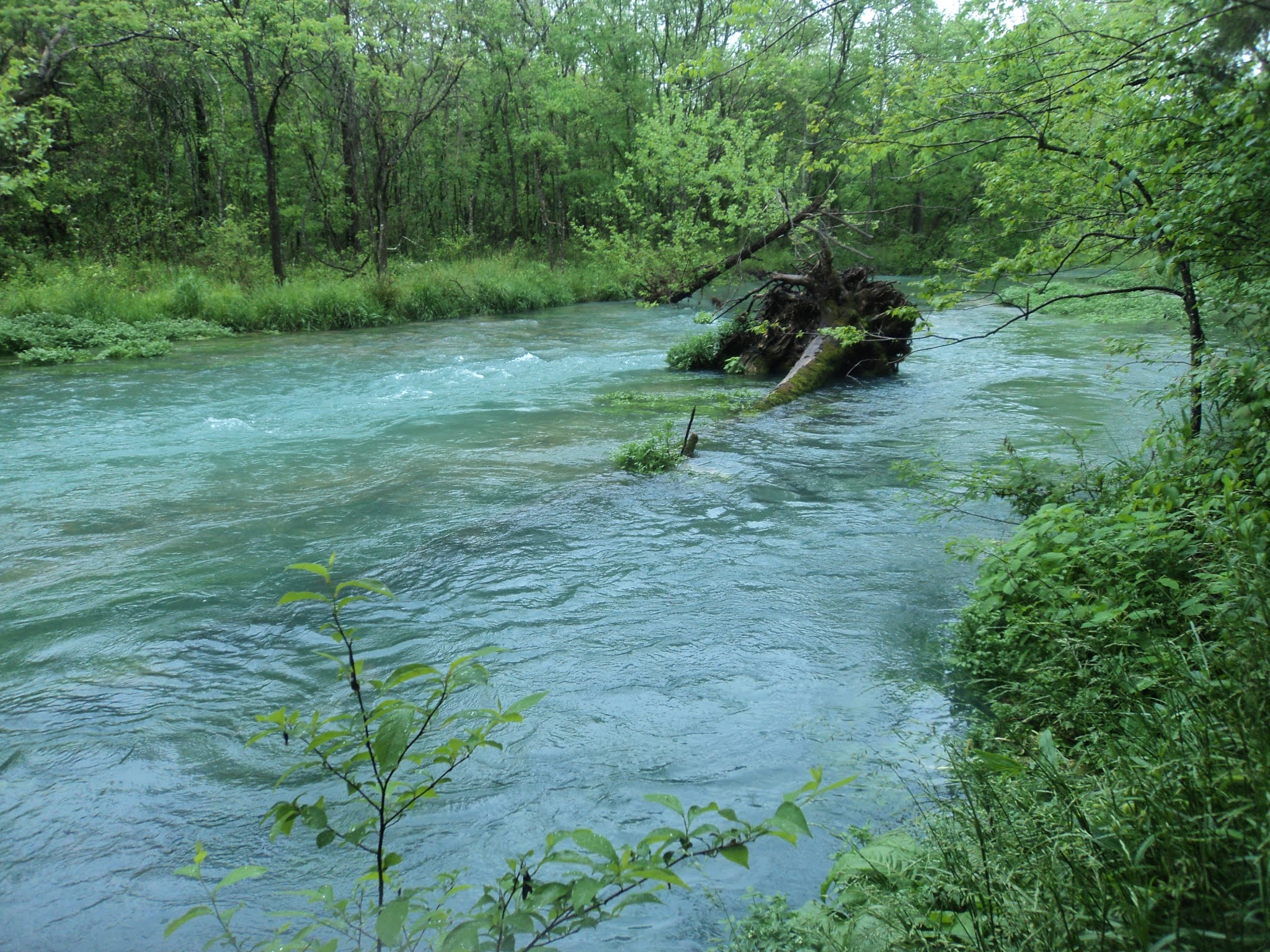
Hiking beside the river floodplain
    
        At 0.4 miles, just as the river comes within sight on the right, the trail curves left and begins heading up a side ravine.  The river's side ravines have steep walls and rocky streams, and you head up two of them before switchbacking to the right and climbing the back side of a larger riverside bluff.  At 0.8 miles, you crest the bluff and reach an unofficial overlook of the Buffalo River.  This point stands about 150 vertical feet above the river, and I could see numerous rafters taking a break on the sandy river banks below.
View from first Buffalo River overlook
    
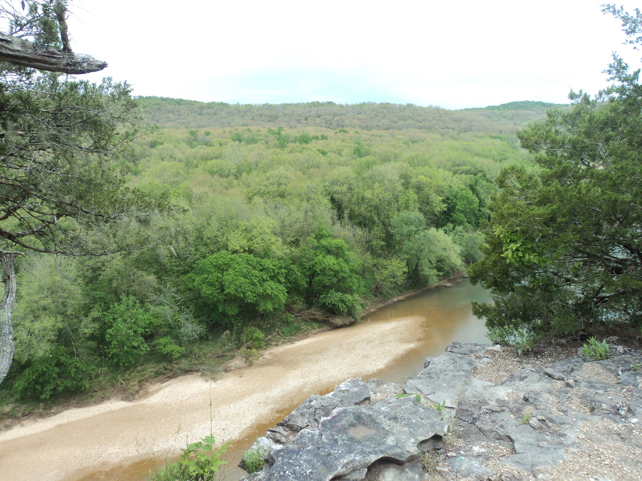
        After heading further up the bluff for a few hundred feet, you reach a signed trail intersection where the Return Trail exits left.  Angle right to remain on the Riverview Trail.  The grade intensifies until, 1 mile into the hike, you reach a developed overlook.  The overlook stands above Arnold Bend, a sharp northward curve in the river that features wide and fertile bottomlands.  The bend is named for the family of William Arnold, who farmed these bottomlands throughout the mid and late 1800's.  This overlook 
provides this hike's best Buffalo River view, so take some time to see what you can see.
Buffalo River view at Arnold Bend
    
        Past the overlook, the trail assumes a wide and flat treadway as it heads directly away from the river.  At 1.3 miles, you reach the rustic Sod Collier Homestead, which consists of a house, fence, and shed.  Built in 1928 by Solomon "Sod" Collier, an immigrant from Kentucky, the log house with metal roof reminds me of similar structures I have seen from the early 1900's in Kentucky and Tennessee.  Take some time to observe the homestead and read the interpretive signs that describe the Collier's way of life.
Collier Homestead
    
        The Buffalo River Trail enters from the right just before you reach the gravel parking lot that serves the Collier Homestead, where the Riverview Trail ends.  To continue this hike, walk through the parking lot and head eastbound on the Buffalo River Trail, which is marked with white rectangular paint blazes.  The Buffalo River Trail crosses the main park road before embarking on a fairly level course on the north side of the park road's ridge.  The soil is quite rocky here, and the many small rocks in the trail make for tricky footing.  Some large oak trees live along this ridge, but the rocky soil and nearby park road make this part of the hike rather uninspiring.
Hiking the Buffalo River Trail
    
        Ignore the Spring Hollow and Buck Ridge Trails that exit left; they offer opportunities to shortcut this hike.  After curving left to pass over a finger ridge, the trail descends moderately to reach a signed intersection with the Rockwall Trail at 2.9 miles.  Turn left to begin the Rockwall Trail; the Buffalo River Trail continues straight and heads out of the park.
            Narrow and rocky, the Rockwall Trail crosses back up and over the finger ridge before beginning a moderate to steep descent using a single switchback.  Upon reaching the bottom of the ravine, you rockhop the watercourse, which was dry on my visit, and begin heading downstream.  At 3.4 miles, the trail exits the mouth of the ravine and curves left to begin following the rock wall for which this trail is named.  The wall is about 4 feet high, and while I could not find any information about this specific wall, it appears to be of the type that were constructed beside farm fields 150 years ago.
Rock wall along Rockwall Trail
    
        3.8 miles into the hike, the Rockwall Trail ends where it comes out at the campground access road.  To find the last segment of this hike, angle first left on the road and then right to begin following the left (west) arm of the developed Tyler Bend Campground loop.  The trail going back to the Visitor Center is marked only by a small wooden sign that says "Visitor Center," and it begins on the left just before you reach campsite #24.
Start of final trail segment
    
        The wide dirt trail heads moderately uphill through a forest of red cedar trees.  After crossing the paved park road that accesses the picnic area and canoe launch, the trail comes out at the east end of the Tyler Bend Visitor Center, thus marking the end of the hike.  While you are here, be sure to check out the Visitor Center, which offers interesting exhibits on the Buffalo River's human and natural history.