Directions to the trailhead: From the intersection of
SR 24 and SR 58 in Cape Carteret, take SR 58 north 0.7 miles to VFW Road and
turn left on VFW Rd.Drive VFW Rd. west
0.5 miles to the entrance for Croatan National Forest’s Cedar Point Recreation
Area on the left.Turn left on the paved
national forest road and drive it 0.8 miles to the picnic area parking lot at
the road’s end.Park here.
The hike: For my introduction to Croatan National
Forest, see the previous hike.Whereas the previous hike
explored the backcountry pinewoods wetlands traversed by the Neusiok Trail,
this hike describes a short frontcountry nature trail that explores the area
around the White Oak River tidal marsh.The
trail’s length, scenery, and location near popular beach destinations mean it
sees plenty of traffic, so do not expect to be alone on this hike.
Tideland Trail trailhead
From the
signed trailhead near the picnic area’s restroom building, the gravel trail
heads northwest into a forest of cedar trees and live oaks.Numerous signs describe the flora and fauna
of the tidal marsh area, but some of the signs were faded and hard to read on
my visit.After only a few hundred feet,
the trail splits to form its loop.To
save the best views of the tidal marsh for last, I chose to turn right and use
the route continuing straight as my return route, thus hiking the loop
counterclockwise.
Hiking along the tidal marsh
The gravel
trail skirts the fringe of the tidal marsh as it curves more left than
right.Numerous benches offer
opportunities to sit and rest if you are so inclined.At 0.4 miles, the short loop exits left and
heads onto a boardwalk.Angle right to
stay on the longer loop and get the full tour.
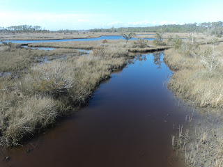
Next the
trail passes around a shallow inlet that offers your first tidal marsh
view.At 0.7 miles, you reach an
unsigned trail intersection.The trail
going right leads to the recreation area entrance road, so you need to turn
left to continue the loop.
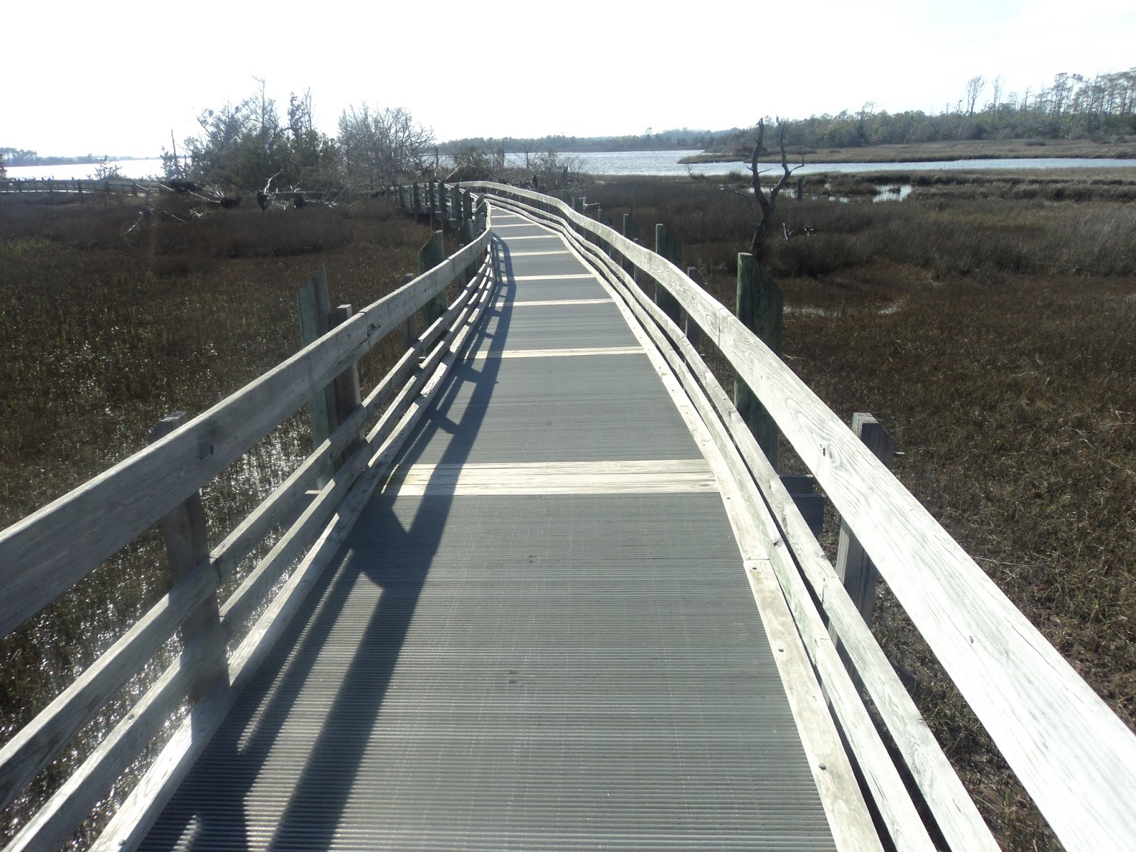
Boardwalk over tidal marsh
View from elevated boardwalk
Just past the trail intersection, you
head out over the tidal marsh on a fantastic highly elevated wooden boardwalk
with metal grate deck.Expansive views appear
in all directions from this sunny boardwalk.When I looked down into the marsh, I saw dozens of tiny crabs crawling
around in the mud.
Standing on edge of White Oak River
The trail
surface goes back and forth between boardwalk and gravel, and two side trails
exiting right take you to the White Oak River’s edge.Excellent views appear up and down the watery
expanse.At 1.3 miles, the short loop
enters from the left, and at 1.4 miles you close the long loop.Retrace your steps 500 feet back to the
parking area to complete the hike.
Directions to the trailhead: From the intersection of
US 70 and SR 101 in Havelock, take SR 101 east 5.1 miles to SR 306 and turn
left on SR 306.Drive SR 306 north 2.1
miles to the Neusiok Trail parking area on the right.The parking area is unsigned, but you reach
it just after passing Apple Drive.Park
in the small gravel parking area.
The hike: Consisting of 160,000 acres of coastal pine
forest and wetlands, Croatan National Forest is the eastern-most national
forest in North Carolina and the only coastal national forest in the eastern
United States.The national forest is
surrounded on three sides by tidal rivers: Bogue Sound to the south, the White
Oak River to the southwest, and the Neuse River to the northeast.These tidal rivers combine with the nearby
wet pine forests of slightly higher elevation to give visitors two distinct habitats
to see.
By far the
best way to see the national forest is by hiking one of its many trails.The forest’s signature trail is the 21 mile
Neusiok Trail (pronounced like new-see-ock), which runs from north to
south across the peninsula between the Neuse River and Bogue Sound.While the entire Neusiok Trail is too long
for a comfortable dayhike, this hike describes one of the trail’s most
interesting sections, a section that features numerous long boardwalks.Combining this hike with the short
interpretive trail described in the next hike gives a good sample of the hiking
Croatan National Forest has to offer.
Neusiok Trail's SR 306 trailhead
From the SR
306 parking area, head south on the Neusiok Trail; a wooden information kiosk
and mandatory self-registration book stand at the start of the trail.Marked by aluminum rectangular markers nailed
to trees, the trail heads southeast through a scruffy mixture of loblolly pines
and oaks.As you approach the Apple
Drive housing development, you pass through an area that has sustained recent
heavy storm damage.Watch for the trail
markers and navigate around the fallen trees and mudholes the best you can.
Hiking through dense forest
After
skirting the perimeter of the housing development, the trail heads into deeper
woods with private property on the left.Some jets from nearby Cherry Point Marine Corps Air Station will likely
zoom overhead, but otherwise the ambiance is quite wild and rustic.In fact, I did not see another person on this
entire hike.At 0.4 miles, you cross the
first boardwalk, which is a baby relative to the boardwalks to come.
This part
of Croatan National Forest is laced with old logging roads that look like
trails, and near 0.6 miles a deceptive old dirt road exits right.A single aluminum marker points left toward
the real trail here, and if you choose to turn right like I did you will end up
in a maze of old logging roads all of which eventually peter out.In general, if you walk more than a couple
hundred feet without seeing a trail marker, you need to turn around and re-find
the trail.
Crossing a boardwalk
Soon you
cross the second constructed boardwalk and then pass through some wet areas on
more primitive wooden structures.At 1.2
miles, you cross Forest Road 143, another old logging road that now deadends at
a private tract of land to your right.At 1.6 miles, you reach the first long boardwalk, a boardwalk that bears
the name Cottonmouth Spa.This
boardwalk’s name turned out to be prophetic: a cottonmouth snake slithered
through the pine needles and vibrated its tail at me while I was crossing a
later boardwalk.
After
dropping off the south end of Cottonmouth Spa, you pass the wooden post that is
the Neusiok Trail’s mile marker 13.At
1.9 miles, you cross sunny Forest Road 136 and reenter the forest on the other
side.Next you cross the boardwalk named
Toad Wallow; this boardwalk is nearly 0.5 miles long!Imagine the time and effort that went into
building these boardwalks, and imagine how horrible this hike would be if you
had to slog through the ankle-deep water they carry you across.
Crossing Toad Wallow
Just after crossing
Toad Wallow, the Neusiok Trail comes out on the north shoulder of SR 101 near
2.7 miles into the hike.An overnight
shelter stands less than 1 mile further south on the trail, and a parking lot
on the south side of SR 101 allows you to park a second car here for a
shuttle.There are no more long
boardwalks between here and the shelter, so I chose to turn around here and
retrace my steps 2.7 miles to complete my journey on the Neusiok Trail.
Directions to the trailhead: Between Columbia and
Florence, take I-20 to Lee State Park Road (exit 123).Exit and drive Lee State Park Rd. north 1
mile to the signed park entrance on the left.Turn left to enter the park, then turn left at the first stop sign,
following signs for the park office.Park in the cul de sac in front of the park office.
The hike: Established in 1935 as one of South
Carolina’s 16 original Civilian Conservation Corps (CCC)-built state parks, Lee
State Park protects 2839 acres of bottomland broadleaf forest on the east bank
of the Lynches River.The park’s
centerpieces are its four natural artesian wells, which spew groundwater 24
hours per day 365 days per year.The CCC
built some stone structures to channel the wells’ waters, and two of these
structures are passed on this hike.
Interestingly,
this park has a near-twin on the other side of the state: Aiken State Park,
which is featured elsewhere in this blog.Other than Lee’s 12
miles of horse trails, the amenities of the two parks are nearly identical: a
cozy 25-site campground, 2 or 3 picnic shelters, and several short hiking
trails.The hike described here takes
you past the artesian wells and along the park’s boardwalk, but it also takes
you along some of the park’s lesser-used trails, thus providing a good sample
of all Lee State Park has to offer.
Start of concrete path near park office
The easiest
trail to find from the parking lot is the boardwalk, so this hike starts with
the boardwalk.A wooden sign that says
“boardwalk” points down a concrete path that goes behind the park office.The concrete path ends at the start of the boardwalk,
which immediately heads out over the wetlands along Lynches River.Water levels were high on my visit, but they
had been higher: a sign on the boardwalk’s railing identifies the high water
mark after Hurricane Florence passed through here in 2018.
Walking the boardwalk
At 0.2
miles, you reach a pair of benches and an interpretive sign where the boardwalk
deadends.Turn around and walk back to
the beginning of the boardwalk where the Floodplain Trail goes left and right.The Floodplain Trail is unsigned, but some white
aluminum diamonds mark the trail.This
hike will eventually go both directions on the Floodplain Trail, but to get to
the artesian wells sooner this description turns right to head southeast on the
Floodplain Trail.
The trail
heads around a collection of small ponds on dikes that define the ponds’
borders.After using an interesting
stone bridge to cross the CCC-built spillway of the largest pond, you reach two
of the artesian wells.These wells may
seem like man-made fountains, but the water source is natural: stone CCC-built
fountains guide the water into the nearby pond.Some benches allow you to sit and enjoy the flowing water.
Artesian well
A loop of
the horse trail sits to the right (east) of the fountains, but this hike stays
on the hiker-only trail as it continues around the pond.After passing through a group of picnic
tables, you arrive back at the parking lot at 0.8 miles to complete the first
loop.To start the second loop, walk
back down the same concrete trail you took to reach the boardwalk before, but
this time when you reach the boardwalk turn right to begin heading northwest on
the Floodplain Trail.
With the
wetland along Lynches River on the left, the sandy dirt trail heads northwest
through a forest that features a mixture of oak and loblolly pine trees.Ignore the Orange Spur, which is marked by
red/orange trail markers and forms a short side loop off of the main
trail.At 1.4 miles, you cross the
park’s dirt Loop Road and reenter the forest on the other side.
Hiking the floodplain trail
Now inside
the park’s Loop Road, the trail follows a serpentine route with the wetlands
occasionally visible to the left.My
approach startled a juvenile cottonmouth snake, which in turn startled me and
caused me to take a short detour to give it more room.Just shy of 2 miles, the trail comes out at
the east side of the park’s Loop Road.Another segment of the Floodplain Trail starts just down the road to the
left, but my encounter with the cottonmouth had given me enough adventure for
one day.Thus, I turned right and walked
the park road back to the parking lot to complete my hike.
Directions to the trailhead: From Walhalla, take SR
28 west 5.3 miles to the signed entrance for the Yellow Branch Picnic Area on
the left.Turn left and drive the short
entrance road down to the picnic area parking lot.The hike starts at the picnic area.
The hike: By some measures Yellow Branch Falls is
just another of the many excellent waterfalls in upstate South Carolina, but
these measures fail to tell the full story.Yellow Branch Falls’ many cascades over irregular rock ledges give the
waterfall a unique look.Also, while
some waterfalls require miles of driving on rough gravel roads, Yellow Branch
Picnic Area’s location right on a major state highway makes the trailhead
easily accessible.Thus, Yellow Branch
Falls is a popular destination, especially on warm weather weekends.
Although
the trail to reach Yellow Branch Falls is a national forest trail, it has a
front-country feel with numerous wooden stair and railing constructions.Nevertheless, the trail also features five
unbridged creek crossings, so I recommend waterproof boots for this hike.When I hiked here two days after a good rain,
the creek crossings had only a few inches of water, but the waterfall still had
enough water to make it a spectacular sight.
Yellow Branch Falls trailhead
An
information kiosk and a brown carsonite post on the south side of the picnic
area identify the trailhead for the Yellow Branch Falls Trail.Marked with orange rectangular paint blazes,
the Yellow Branch Falls Trail heads downstream with Yellow Branch flowing to
your left.Some dense rhododendron grows
beside Yellow Branch, but otherwise the forest is a nice open broadleaf
forest.At 0.15 miles, you reach the
first creek crossing.Stone steps take
you right to the water, but the stepping stones in the creek were underwater on
my visit.
First unbridged creek crossing
Two more
creek crossings come in quick fashion, and one of these crossings comes just
below a small ledge-type waterfall.At
0.3 miles, you reach a trail intersection.As directed by another brown carsonite post, you need to turn right here
to keep heading for Yellow Branch Falls.
Bridge over Yellow Branch
Next you
cross Yellow Branch on a wooden bridge, one of only two bridges on this
trail.The final Yellow Branch crossing
is unbridged, but before you make this crossing look for a faint path that
continues straight along the west bank of Yellow Branch.Now blocked by limbs placed strategically
across the treadway, this path is the old route to Yellow Branch Falls.While the narrower old route was 0.2 miles shorter,
it treaded precariously close to the stream and thus suffered from erosion
problems. Reading some descriptions of the old trail convinced me of the current
route’s advantages.
Descending into unnamed ravine
After
crossing Yellow Branch for the last time, the trail heads over a low saddle to
enter a broad ravine with an unnamed watercourse.The small stream is crossed once without the
aid of a bridge, and a gradual descent continues.1 mile into the hike, the trail curves right
and begins climbing as you pass the lowest elevation on this hike.This point is roughly 260 vertical feet below
the elevation of the trailhead.
Descending over wooden steps
The trail
treads around a couple of finger ridges, and partially obstructed views of the
Walhalla area can be had to the left during the leafless months.After rounding the last finger ridge, you
begin the final descent to Yellow Branch Falls via some wooden steps built into
the ground.You will hear Yellow Branch
before you see the falls, and the narrow trail makes this section the hardest
part of the hike.
Yellow Branch Falls
Yellow Branch Falls
At 1.6
miles, you reach the base of Yellow Branch Falls.The 60-foot fan-type waterfall features
numerous drops over irregular rock ledges, and the odd angle gives it a
distinct appearance.Several rocks near
the falls’ base beckon you to sit, rest, and enjoy a trail snack in the
waterfall’s company.The trail ends at
the falls, so after enjoying the aquatic scenery you must retrace your steps
more uphill than down to the picnic area to complete the hike.
Directions to the trailhead: Just north of downtown
Charleston, take I-26 to SR 7 (exit 216A).Exit and go south on SR 7.Drive
SR 7 south for 1.8 miles, then angle left on SR 171.The entrance to Charles Towne State Historic
Site is another 0.5 miles ahead on the left.There is a traffic light at the site entrance, but otherwise the
entrance is not well marked.Turn left
to enter the site, park in the large visitor parking lot, and pay your
admission fee at the Visitor Center, where this hike begins.
The hike: The year was 1670 when a group of English
settlers landed on Albemarle Point on the west bank of the Ashley River.The settlers built a small fortified
community that would become the first permanent English settlement in present-day
South Carolina, and they named their community Charles Towne after the King of
England, King Charles II.This
settlement would become the birthplace of the Carolina colony and the American
South’s plantation system.
Within 10
years a newer settlement on Oyster Point on the opposite east bank of the
Ashley River had outgrown Charles Towne, and the capital of the Carolina Colony
was moved to that site, which is present-day downtown Charleston.The original Charles Towne became known as
Old Town Plantation, and it would be farmed for almost the next 300 years.The land’s last private owners were Dr. and
Mrs. Joseph Waring, who built an ornate house and garden on the site.In 1969, the land was sold to the State of
South Carolina, which developed the land as a state park.The park opened in 1970 to commemorate
Charles Towne’s tricentennial.
Today the park
goes by the name Charles Towne Landing State Historic Site, and it offers an
interesting mix of recreated history, actual history, and present-day
attractions.On each point, a recreated
fort with buildings sits where the original fort once stood, and the Adventure
recreates the 17th century ship the original settlers would have
sailed on.The ornate Legare-Waring
House and adjacent garden await visitors’ exploration, and the park’s Animal Forest
offers a small zoo with many live animals on exhibit.You could easily spend several hours
exploring all there is to see, and the 2.9 mile loop described here gives a
good overview of the site.
Pond and fountain beside Visitor Center
The
exhibits in the Visitor Center give a good idea of what life was like in 1670
Charles Towne.After browsing and
interacting with the exhibits, walk out the side door marked as leading to the
History Trail.A plastic-board deck
overlooking a nice pond with gushing fountain greets you as you step out of the
Visitor Center.
Start of History Trail
The asphalt
History Trail heads east through an arboretum-like setting that featured some
flowering redbuds on my late February visit.At the next intersection, turn left to follow signs for the Animal
Forest.Next you pass a slave cemetery
on the right; the cemetery would be hard to find without the signs that mark
and interpret it.
At 0.3
miles, you enter the Animal Forest exhibits.The exhibits include an aviary featuring some pelicans and herons, some
river otters, a black bear, a puma, a bison/elk pen, and a fantastic bald
eagle.Take some time to observe and
learn what you can learn about bird and animal behaviors.
Pelicans in Animal Forest
Bison pen in Animal Forest
After
touring the Animal Forest, walk back out toward the History Trail, but before
you reach the slave cemetery turn left to leave the asphalt and begin the
site’s Nature Trail.The Nature Trail is
unmarked, but the dirt path was obvious on my visit.The Nature Trail leads to a bench offering a
nice view across Ashley River, which at this point appears more as a tidal
marsh than a river.
Hiking the Nature Trail
The Nature
Trail heads south along the west bank of the Ashley River via a well-trodden
dirt treadway.When a pond comes into
view, take a quick detour to the right to view the stately statue of Cassique
of the Kiawah.Kiawah Chief
Cassique led Charles Towne settlers to build on this site and was a friend to
the new-found colony.After viewing the
statue, continue south to the left of the pond to reach a white tent where some
archaeological excavations were on-going on my visit.
Cassique of Kiawah
Past the
tent, you reach the south end of the Nature Trail where it rejoins the asphalt
History Trail.At 1.7 miles, the trail
passes through the reconstructed palisade wall to enter the site of the
original Charles Towne settlement.Some
cannons, some stocks, a crop garden, a common house, and more archaeology
exhibits will be found here.The
mowed-grass area makes it easy to imagine what this settlement may have looked
like 300+ years ago.
Reconstructed fort area
Just shy of
2 miles, you reach the tip of Albemarle Point, which offers fantastic views of
downtown Charleston across the Ashley River.Continuing around Albemarle Point brings you to the 17th
century-style Adventure ship’s dock.Adventure is moved to another location for annual maintenance every January
and February, so I did not get to see the ship.
Ashley River at Albemarle Point
Next the
trail crosses a wooden boardwalk that offers fantastic views up and down Old
Towne Creek, another marsh-looking waterway.The asphalt History Trail winds past some more archaeology exhibits
before reaching the south end of the Avenue of Oaks.As its name suggests, the Avenue of Oaks is a
tunnel of live oak trees, and the lavish Legare-Waring House stands at its
north end.
Avenue of Oaks
Where the
asphalt trail splits, turn left to hike the English Garden Trail, which forms a
short loop through Mrs. Waring’s Garden.Some pink azaleas in bloom brightened the garden on my visit, and
another overlook gives a final view of Old Towne Creek.I saw a blue heron perched beside a blooming
azalea bush, and I flushed a group of robins out of the bushes.
Azalea and heron
After
crossing the Legare-Waring House entrance road, you pass a 700-year-old live
oak tree.Follow the History Trail as it
winds its way to the rear entrance of the Visitor Center, thus completing the
hike.Take some time to browse the
exhibits and gift shop in the Visitor Center on your way out if you did not do
so before.