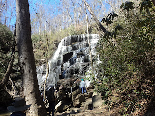
Hike Location: Sumter National Forest, Yellow Branch Picnic
Area
Geographic Location: northwest of Walhalla, SC (34.80550, -83.12835)
Length: 3.2 miles
Difficulty: 5/10 (Moderate)
Date Hiked: March 2020
Overview: An out-and-back to interesting Yellow Branch
Falls.
Trail Information: https://www.fs.usda.gov/recarea/scnfs/recarea/?recid=47137
Hike Route Map: https://www.mappedometer.com/?maproute=786586
Photo Highlight:
Hike Video:
Directions to the trailhead: From Walhalla, take SR
28 west 5.3 miles to the signed entrance for the Yellow Branch Picnic Area on
the left. Turn left and drive the short
entrance road down to the picnic area parking lot. The hike starts at the picnic area.
The hike: By some measures Yellow Branch Falls is
just another of the many excellent waterfalls in upstate South Carolina, but
these measures fail to tell the full story.
Yellow Branch Falls’ many cascades over irregular rock ledges give the
waterfall a unique look. Also, while
some waterfalls require miles of driving on rough gravel roads, Yellow Branch
Picnic Area’s location right on a major state highway makes the trailhead
easily accessible. Thus, Yellow Branch
Falls is a popular destination, especially on warm weather weekends.
Although
the trail to reach Yellow Branch Falls is a national forest trail, it has a
front-country feel with numerous wooden stair and railing constructions. Nevertheless, the trail also features five
unbridged creek crossings, so I recommend waterproof boots for this hike. When I hiked here two days after a good rain,
the creek crossings had only a few inches of water, but the waterfall still had
enough water to make it a spectacular sight.
 |
| Yellow Branch Falls trailhead |
An
information kiosk and a brown carsonite post on the south side of the picnic
area identify the trailhead for the Yellow Branch Falls Trail. Marked with orange rectangular paint blazes,
the Yellow Branch Falls Trail heads downstream with Yellow Branch flowing to
your left. Some dense rhododendron grows
beside Yellow Branch, but otherwise the forest is a nice open broadleaf
forest. At 0.15 miles, you reach the
first creek crossing. Stone steps take
you right to the water, but the stepping stones in the creek were underwater on
my visit.
 |
| First unbridged creek crossing |
Two more
creek crossings come in quick fashion, and one of these crossings comes just
below a small ledge-type waterfall. At
0.3 miles, you reach a trail intersection.
As directed by another brown carsonite post, you need to turn right here
to keep heading for Yellow Branch Falls.
 |
| Bridge over Yellow Branch |
Next you
cross Yellow Branch on a wooden bridge, one of only two bridges on this
trail. The final Yellow Branch crossing
is unbridged, but before you make this crossing look for a faint path that
continues straight along the west bank of Yellow Branch. Now blocked by limbs placed strategically
across the treadway, this path is the old route to Yellow Branch Falls. While the narrower old route was 0.2 miles shorter,
it treaded precariously close to the stream and thus suffered from erosion
problems. Reading some descriptions of the old trail convinced me of the current
route’s advantages.
 |
| Descending into unnamed ravine |
After
crossing Yellow Branch for the last time, the trail heads over a low saddle to
enter a broad ravine with an unnamed watercourse. The small stream is crossed once without the
aid of a bridge, and a gradual descent continues. 1 mile into the hike, the trail curves right
and begins climbing as you pass the lowest elevation on this hike. This point is roughly 260 vertical feet below
the elevation of the trailhead.
 |
| Descending over wooden steps |
The trail
treads around a couple of finger ridges, and partially obstructed views of the
Walhalla area can be had to the left during the leafless months. After rounding the last finger ridge, you
begin the final descent to Yellow Branch Falls via some wooden steps built into
the ground. You will hear Yellow Branch
before you see the falls, and the narrow trail makes this section the hardest
part of the hike.
 |
| Yellow Branch Falls |
 |
| Yellow Branch Falls |
At 1.6
miles, you reach the base of Yellow Branch Falls. The 60-foot fan-type waterfall features
numerous drops over irregular rock ledges, and the odd angle gives it a
distinct appearance. Several rocks near
the falls’ base beckon you to sit, rest, and enjoy a trail snack in the
waterfall’s company. The trail ends at
the falls, so after enjoying the aquatic scenery you must retrace your steps
more uphill than down to the picnic area to complete the hike.
No comments:
Post a Comment