Thursday, January 22, 2015

Cove Lake State Park (Blog Hike #504)

Trail: (unnamed)
Hike Location: Cove Lake State Park
Geographic Location: north side of Caryville, TN (36.30929, -84.21887)
Length: 1.4 miles
Difficulty: 1/10 (Easy)
Dates Hiked: January 2015, March 2023
Overview: A fairly flat hike on asphalt trail through wooded creekside habitat.
Hike Route Map: https://www.mappedometer.com/?maproute=727606
Photo Highlight:
Hike Video:

Directions to the trailhead: North of Knoxville, take I-75 to US 25W in Caryville (exit 134).  Exit and go north on US 25W.  Drive US 25W north 0.9 miles to the park entrance on the left.  Turn left to enter the park, then proceed straight at each intersection to the main park road’s end at a parking circle just uphill from the lake.  Park here.

The hike: Like its brother/sister state parks Norris Dam and Big Ridge, Cove Lake State Park has its roots in the depression-era Tennessee Valley Authority (TVA).  The TVA’s construction of Norris Dam on the Clinch River several miles downstream caused water to back up into Cove Creek, which in turn threatened to flood the town of Caryville.  The TVA’s solution was to build a second auxiliary dam on Cove Creek called Caryville Dam.  Water held back by Caryville Dam created Cove Lake, the centerpiece of this state park.
            In addition to the lake, Cove Lake State Park features a 106-site campground, a Recreation Village that contains tennis courts, a swimming pool, and a restaurant, and several picnic shelters.  In hiking circles, the park is best known as an access point for the Cumberland Trail, the master path of eastern Tennessee.  When complete, the Cumberland Trail will trace a diagonal course for more than 300 miles from Cumberland Gap National Historic Park in the northeast to Chattanooga-Chickamauga National Military Park in the southeast.  Check the website of the Cumberland Trail Conference at http://cumberlandtrail.org/website/ for trail construction updates.
            For dayhikers, Cove Lake State Park is the least desirable of northern Tennessee’s three TVA state parks because its trails do not form loops.  Some short out-and-backs can be done starting at the campground, and an unnamed paved trail makes a figure-eight route along the east bank of Cove Lake.  In my view, the best option for dayhikers is the northern lobe of the figure-eight trail, which is the hike described here.  Although the trail is paved, the route stays in the woods most of the time and explores the headwaters of Cove Lake.
Signs at trailhead
            Pick up the paved trail at an information board and directional sign near the back of the parking circle.  The trail is open to both foot and bicycle traffic.  To minimize the potential for collisions, park regulations require that bikers turn left and ride the loop clockwise while hikers must turn right and walk the loop counterclockwise.
            The asphalt trail immediately enters the woods and undulates gently as it makes a sweeping 180-degree turn to the left.  I heard and saw many songbirds here including robins, sparrows, woodpeckers, and cardinals.  This trail would make a very nice short hike but for the ugly asphalt constantly stretching out before you.  On the bright side, your feet will stay dry on this trail even when other dirt trails are too muddy for comfortable hiking.
Hiking the paved trail
              At 0.2 miles, you reach a point where the other western arm of the loop comes very close on the left.  The loop continues as the trail curves right and approaches a power line that sits just over the park’s eastern boundary.  The trail never passes under the power line but instead curves back left to stay in the woods.  The next segment of trail parallels the park boundary, which lies immediately to your right.
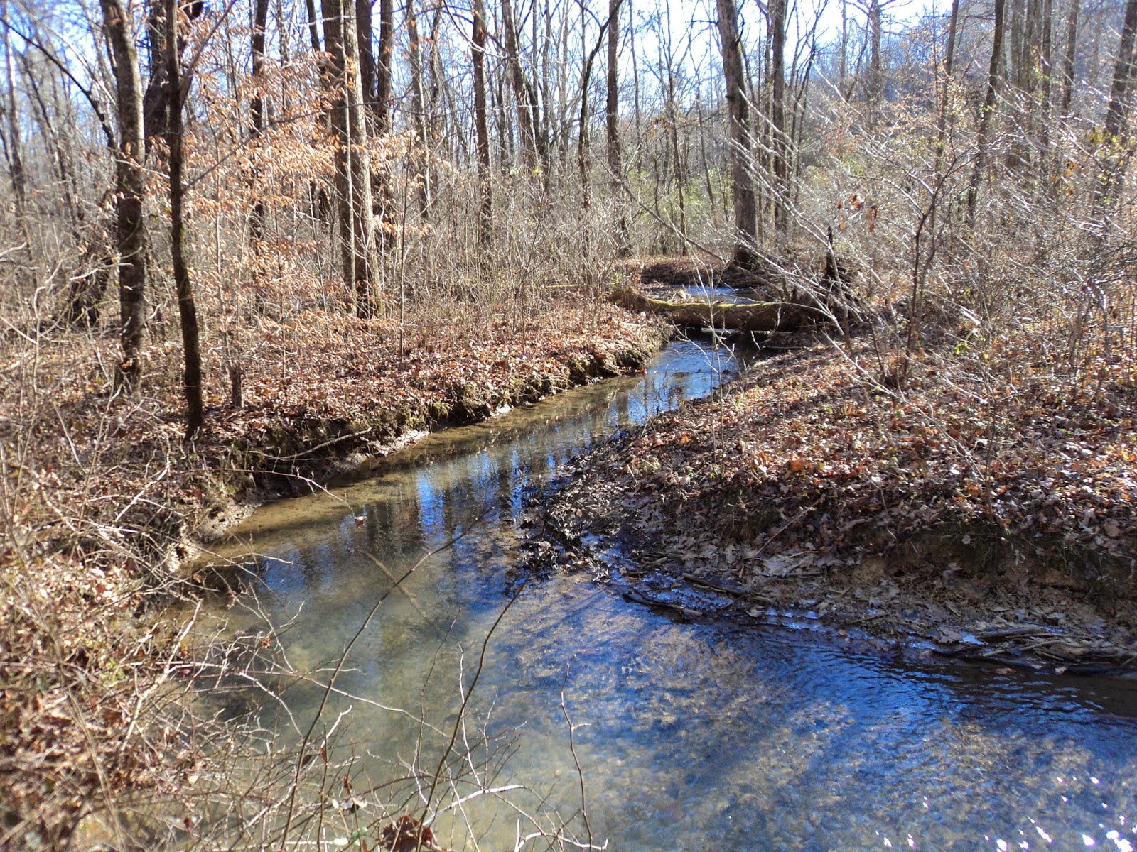
            Near 0.5 miles, you reach the trail’s northern-most point as it makes a sweeping left turn to begin heading south.  One of the main streams that feed Cove Lake comes into view on the right for the first time here.  When I hiked this trail on a cold winter afternoon, thin layers of ice remained on the edges of the creek’s shallow waters.
Feeder stream for Cove Lake
            The trail meanders south as the creek weaves in and out of sight on the right.  At 0.8 miles, a dirt trail exits right.  A sign identifies this trail as the Beaver Workshop Loop and Cumberland Trail Access, but it quickly led to a frozen wetland on my visit.  Thus, I chose to remain on the main paved loop.
Cove Lake
            The primary direction remains south as Cove Lake’s backwaters begin to appear to the right.  Just before closing the loop, you pass a wooden wildlife observation tower that was inaccessible due to high water on my visit.  I managed to see some Canada geese in the lake even without the tower.  The lake comes into view just as you approach the parking circle, thus marking the end of the loop.  If you want more lake views, you can continue straight and hike the southern lobe of the paved figure-eight-shaped trail for just under another 2 miles, but that lobe passes through a more developed area of the park than the nice woodland loop you just completed.

Sunday, January 11, 2015

Santee State Park: Hiking/Biking Trail (Blog Hike #503)

Trail: Hiking/Biking Trail
Hike Location: Santee State Park
Geographic Location: northwest of Santee, SC (33.54785, -80.49837)
Length: 7.2 miles
Difficulty: 4/10 (Easy/Moderate)
Date Hiked: December 2014
Overview: A long woodland loop, partially on old roads, with nice Lake Marion views.
Hike Route Map: https://www.mappedometer.com/?maproute=727304
Photo Highlight:

Directions to the trailhead: In central South Carolina, take I-95 to SR 6 (exit 98).  Exit and go west on SR 6.  Drive SR 6 west 1.2 miles to State Park Road and turn right on State Park Rd.  State Park Rd. ends at the park entrance.  After entering the park, drive to the park’s main crossroads, then continue straight another 1.9 miles to the signed trailhead parking on the right.  There is enough space here for 5 or 6 cars.  If this lot is full, you can park at the picnic area or park store a few hundred feet further down the road.

The hike: For my general comments on Santee State Park, see my blog entry for the Limestone Nature Trail, which is also at this park.  I was unable to hike the long Hiking/Biking Trail on my September visit due to the physical abilities of other members in my group, so I came back (by myself) in December to hike it.  I had a nice hike on that cool December day, and I did not meet another single person on the trail.  If you hike this trail in the busier summer months, note that there is no potable water on this trail, so be sure to pack all of the water you will need.
Trailhead: Hiking/Biking Trail
            The trail starts at the right side of the parking area and heads through a gap in a wooden fence.  Almost immediately the trail forks to form its loop.  To get to the bluff overlooking Lake Marion faster, I chose to take the left fork and hike the loop clockwise, thus using the right fork as my return route.  The single-track trail heads east over very flat terrain through a forest dominated by loblolly pines.
            At 0.3 miles, you reach a trail junction as you intersect an old road.  Turning left would lead a short distance to the park’s campground, so this hike turns right to continue the Hiking/Biking Trail.  Lake Marion, some 40 feet below you, becomes visible through the trees to your left.
Hiking atop the bluff
            The trail follows the old sandy-dirt road for more than 2 miles along the top of the bluff that overlooks Lake Marion.  The lake remains in view through the trees most of the time, but no unobstructed views can be had from the trail.  The trail briefly heads inland away from the bluff edge just before you reach the wooden post that is the 1 mile marker.  Some blue blazes mark a faint short cut trail that exits right, but the main Hiking/Biking Trail continues straight on the wide old road.  Note that the short cut trail does not appear on the park’s trail map, but it is well-blazed and reduces this hike to just over 2 miles in length.
            Continuing on the full loop, the trail heads back to the bluff edge as it maintains its southward course.  Near 1.7 miles, the trail curves right to leave the bluff edge and begin a long horseshoe-shaped section around a wide, long, shallow ravine that feeds Lake Marion.  A swamp forest complete with bald cypress and tupelo trees lies at the bottom of this ravine.  At 2.4 miles, you reach a bench that overlooks this small swamp forest.
Lake Marion
            Just past the bench, the trail completes the horseshoe and arrives back at the bluff edge yet again.  The trail’s best lake view opens up to the left at this point.  After dipping through another small ravine, you reach a trail intersection at 3.2 miles.  The old road continues straight and quickly arrives at the park’s main picnic area.  As directed by a metal arrow nailed to a post, the Hiking/Biking Trail turns right to leave the old road and begin the western half of the loop.
            The remainder of the hike uses the newest trail in the park, and consequently the path on the ground is not nearly as wide or well-worn as what you have hiked so far.  Thus, you will need to watch for the blue blazes to stay on the trail.  The meandering trail heads in the general direction of west before curving right to head north back toward the trailhead.  This segment of trail runs very close to the park road on the left, but this park is rural enough so that little traffic runs up and down these roads.
Wooden boardwalk over wet area
            Near 5.2 miles, the trail crosses a small seasonally wet area on a wooden boardwalk.  After curving right to head away from the park road, you pass through an area that featured a large number of downed trees on my visit.  I was thankful that park crews had worked hard here to clear the trail.
            Near 6.3 miles, the west end of the short-cut trail enters from the right.  There are many blue blazes in this area, but no sign marks this junction.  If you accidentally take the short-cut trail instead of the main trail (as I did), you will arrive back at the 1-mile marker on the east side of the loop.  In that case, you will need to turn around and retrace your steps 0.3 miles, looking for the main trail to exit right.  The remainder of the hike passes over a low ridge as it works its way back to the trailhead.  Your car comes into view through the trees ahead and to the left as you close the loop and complete the hike.

Monday, January 5, 2015

Palmetto Islands County Park: Osprey and Nature Island Trails (Blog Hike #502)

Trails: Osprey and Nature Island Trails
Hike Location: Palmetto Islands County Park
Geographic Location: northwest of Mt. Pleasant, SC (32.86406, -79.83265)
Length: 1.9 miles
Difficulty: 1/10 (Easy)
Date Hiked: December 2014
Overview: A flat nature hike with good marshland views.
Hike Route Map: http://www.mappedometer.com/?maproute=376028
Photo Highlight:

Directions to the trailhead: On the east side of Charleston, take I-526 to Long Point Road (exit 28).  Exit and go east on Long Point Rd.  Drive Long Point Rd. 1.9 miles to Needlerush Parkway; there is a traffic circle at this intersection.  Take the traffic circle’s second exit to head north on Needlerush ParkwayNeedlerush Parkway ends at the park entrance 1.4 miles later.  Park in the sand/gravel parking lot in front of the Park Center, where this hike begins.

The hike: Located on the east side of suburban Charleston, Palmetto Islands County Park occupies 943 acres on a double peninsula of land surrounded by saltwater marsh.  The somewhat developed park offers several amenities, including Splash Island (a small water park), a playground, several picnic shelters, a kayak launch, and several fishing docks.  The people of Charleston are fortunate to have a park like this one so close to the city.
The park’s name comes from the numerous wooded islands that dot the marsh.  While several of the islands are slated for future trail construction, only one of them is currently accessible by trail; that island is called Nature Island.  The park has several interesting short hiking trails, but this hike focuses on Nature Island, the main natural feature in this park.
Osprey Trail starts at boardwalk
Start at the east side of the Park Center where the dirt Osprey Trail leaves the paved Bicycle Trail.  The Osprey Trail is marked with yellow plastic diamond blazes, but its starting point is most easily identified by a sign bearing the number 4 that corresponds to stop #4 on the park’s cell phone tour.  The trail immediately heads out onto a wooden boardwalk that offers your first broad marsh views.  But for a nearby high voltage power line and distant cranes belonging to the Port of Charleston, you could mistake this park for a remote saltwater marsh.
View north across marsh
            Once across the boardwalk, the trail narrows and turns to dirt.  The rest of the Osprey Trail treads through a narrow arc of dry land with the Bicycle Trail on the left and marsh on the right.  Honestly, the Osprey Trail is not the most scenic trail in this park, but as a means to get to Nature Island it easily beats the paved Bicycle Trail.
At 0.3 miles, you reach the signed trail to Nature Island, which exits to the right.  Turn right to follow the green plastic diamond blazes as they head across a sunny boardwalk over the marsh.  This boardwalk had recently been rebuilt on my visit, and I could still see the grassless strip of muddy marsh that sat under the old boardwalk.  The marsh will quickly reclaim the barren strip, so do not expect it to be there on your visit.
Boardwalk to Nature Island
Shortly after reaching Nature Island, the Nature Island Trail splits to form its loop.   As directed by a black arrow printed on a green plastic diamond, I chose to turn left and hike the loop clockwise.  This island is only a couple feet higher in elevation than the surrounding marsh, but it is enough to keep your feet dry and support a mixed pine/deciduous forest with lots of palmetto in the understory.  The island feels like a remote area even though it lies in metropolitan Charleston.
The trail curves right as it stays near the edge of the island.  At 0.7 miles, you pass the western-most point on the island and a bench that gives the trail’s best marsh view.  The water comes right up to the island here, and marsh grass extends for miles to the west.
View west from Nature Island
The trail reaches the island’s northern-most point and another nice marsh view before curving right to cross a wet area on a boardwalk.  Near 1 mile into the hike, you pass an algae-covered pond on the left.  My approach sent a couple of turtles plopping into the water.
Algae-covered pond
Just after passing the pond, you close the Nature Island Trail’s loop.  Turn left and retrace your steps back across the boardwalk to the mainland, then turn right to continue the Osprey Trail’s loop.  As before, the Osprey Trail stays in a narrow strip of land between the marsh on your right and the park road/parking lot on your left.
At 1.5 miles, the trail turns to asphalt as you pass a private residence on the right and cross the parking lot exit and entrance roads.  1.6 miles into the hike, you intersect the paved Bicycle Trail as you pass the park’s playground on your left.  Turn left to begin the final segment of this hike, a wide asphalt path on which the Osprey and Bicycle Trails run conjointly.  0.3 miles later, you reach the back of the Park Center, thus concluding the hike.