Hike Location: Caesar Creek State Park
Geographic Location: southeast of Waynesville , OH (39.50587,-84.05198)
Length: 4.4 miles
Difficulty: 5/10 (Moderate)
Difficulty: 5/10 (Moderate)
Dates Hiked: 1998, June 2013, August 2016
Overview: A rolling hike along the west shore of Caesar Lake .
Park Information: https://ohiodnr.gov/wps/portal/gov/odnr/go-and-do/plan-a-visit/find-a-property/caesar-creek-state-park
Directions to the trailhead: From Waynesville, take SR 73 east to Clarksville Road . There is a large brown sign that says "Caesar Creek Lake Clarksville Rd. and follow it south to where Middletown Road goes off to the right. Immediately across from Middletown Road , the entrance to the Day Lodge goes off to the left. Turn onto this road and park in the gravel lot in front of the Day Lodge at the end of the road.
The hike: For my comments on Caesar Creek Lake
The advanced hiker may consider a 13.5 mile loop around the southern end of the lake. Such a hike would start at the Visitor Center, proceed north to SR 73, cross the lake on the SR 73 bridge, then head south on the other side of the lake. Crossing the dam at the very southern end of the lake would conclude the hike. Our hike is suitable for the more average hiker. This hike covers the southern 2.2 miles of this trail from the Day Lodge south to the Visitor's Center, as well as a couple of shorter trails near the Visitor's Center.
 |
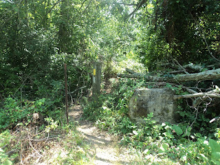
| Perimeter and Buckeye Trail blazes near Day Lodge |
The trail begins by descending through a young forest, then dips through a couple of shallow ravines. The trail then makes a left turn alongside a rusted barbed-wire fence and enters a long straight stretch heading for the lake and descending gradually all the time. The fence is a relic from the days that this land was farmed. Barbed wire fences such as this were used to mark boundaries between two plots of land.
 |
| Hiking on an old road |
A blue arrow painted on the pavement tells you to turn left down the hill toward the lake. A few hundred feet later, the trail reenters the woods on the right side, again cued by a blue arrow. The trail begins descending, with the lake in view on the left through the trees. After reaching the bottom of the ravine, the hiking gets a little more rugged, as the trail begins ascending for the first major climb of the hike.
 |
| Upland portion of Perimeter Trail |
The trail soon leaves the cedars and returns to the deciduous forest, which is comprised mostly of maples with a few beech trees thrown in. This section of forest is made more interesting by a dense lower layer of paw paw bushes on either side of the trail. Shortly, the trail turns left and begins descending into a steep ravine using small, wooden steps. At the bottom of the hill is an old bridge which makes a nice place to rest. This bench is about half way to the visitor's center.
The trail climbs the other side of the ravine, again using steps, for the second major climb of the hike. The trail meanders through the forest for the next several hundred feet, then makes a left turn along a hogsback, heading straight for the lake. A short, but steep descent takes you to a clearing that provides a great view of the lake and the dam. The trail does a U-turn at this point and begins heading up a creek valley following an old wagon trail. The banks of the creek are sufficiently steep to force the trail upstream in search of a good spot to cross. A few hundred feet later, the trail finds it, crosses the creek on stepping stones, then does another U-turn and heads back for the lake.
 |
| Perimeter Trail near lake |
 |
| Fishing pond near Visitor Center |
 |
| Caesar Creek Lake, as seen from overlook |
No comments:
Post a Comment