Friday, June 28, 2013

Foothills Trail to Upper Whitewater Falls (Blog Hike #396)

Trail: Foothills Trail to Upper Whitewater Falls
Hike Location: Bad Creek Foothills Trail Access
Geographic Location: north of SalemSC (35.01231, -82.99905)
Length: 6 miles
Difficulty: 6,10/10 (Difficult)
Date Hiked: September 2012, April 2021
Overview: An out-and-back with one difficult section to the tallest waterfall in the east.
Photo Highlight:
Hike Video: 

Directions to the trailhead: From the intersection of SR 11 and SR 130, take SR 130 north 10.2 miles to the Bad Creek Access Road.  Turn right on the access road.  Drive the paved access road 2.4 miles steeply downhill, turning left once as you follow signs for the Foothills Trail.  Park in the large blacktop Foothills Trail Access parking lot.

The hike: Gashing into the land along the South Carolina-North Carolina border, the Jocassee Gorges comprise 5 steep, rugged ravines around rivers that form major tributaries of man-made Lake Jocassee.  The lake and the gorges are used by Duke Energy for power generation.  On point, the final road you drove down on your way to the trailhead is the access road for Duke Energy’s Bad Creek Pumped Storage facility.  Water is pumped into the facility at times of low electricity demand and then released through turbines to generate electricity at times of high demand.
            Duke Energy also owns and manages this trailhead and about half of the trail used on this hike; the other half passes through the Nantahala National Forest of North Carolina.  Thus, while the trailhead for this hike is in South CarolinaUpper Whitewater Falls lies in North Carolina.  In addition to the thrill of hiking across a state line, you get to enjoy the aptly named Whitewater River while hiking to a major waterfall.
            Before describing the hike, I should mention that if all you want to do is see the waterfall, there is a far easier way to do it than taking this hike.  If you continue driving north on South Carolina SR 130 past Bad Creek Access Road, you will quickly enter North Carolina and come to a signed national forest parking area on the right.  From this parking area, it is only a 0.2 mile walk, mostly on wooden steps, to the waterfall viewing platform reached in 3 miles here.
Bad Creek Access Foothills Trailhead
            To get to the waterfall the long and scenic way, begin at the Foothills Trail’s Bad Creek Access and pick up the blue-blazed trail that leaves the parking area at a collection of information boards.  The trail climbs beside a concrete drainage channel to reach an overlook that offers partially obstructed views of Lake Jocassee to the right.  The trail curves sharply left to cross some shrubby disturbed land, likely a result of the pumped storage construction.
            The trail curves right at a metal stake bearing blue paint to leave the disturbed area and enter the forest.  The forest is a mixture of pine and deciduous trees, most numerously maple trees.  The largest and smallest trees are pines while the deciduous trees occupy the middle.  The trail tops a small rise and then descends to the Whitewater River on a moderate grade using 3 switchbacks marked by double blue blazes.  Some wooden steps built into the ground further ease the descent.
Descending toward Whitewater River
            At 0.7 miles, you cross the Whitewater River on a pair of iron bridges that connect either bank to an island in the middle of the river.  Many large logs have collected on the island, evidence of the river’s power during times of high water.  Given the logs, I am surprised these bridges have survived as well as they have.
Twin bridges across Whitewater River
            Immediately after crossing the river, the access trail intersects the Foothills Trail proper, which goes straight and left.  Heading straight would take you east on the Foothills Trail to Lower Whitewater Falls (another worthy destination described elsewhere in this blog), but this hike turns left to head west on the Foothills Trail to Upper Whitewater Falls.
Intersecting the Foothills Trail
            South Carolina boasts three major backpacking trails: the Swamp Fox Trail in the low country, the Buncombe Trail between Greenville and Columbia, and the Foothills Trail in the extreme upstate.  Due to the upstate’s high relief, the Foothills Trail features the best mountain scenery.  The trail starts at Oconee State Park in the west and meanders along the North Carolina-South Carolina border for 75 miles to its eastern terminus at Table Rock State Park.  The Foothills Trail is a real treasure of the upstate, and the segment used here gives a nice sample of what it has to offer.
            The white-blazed Foothills Trail begins on a wide, level course with cascading Whitewater River to your left.  The splashing of the aptly-named river will be your near-constant companion for the rest of the hike.  The trail passes through what would appear to be an established campsite except for a sign that says, “No camping.”
Steps around rock outcrop
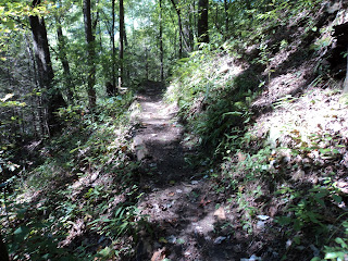
            1.3 miles into the hike, the trail curves right to head a short distance up Pams Creek before crossing the creek on a nice wooden footbridge.  The next segment of trail is built into the hillside 30-50 feet above the river.  Minor changes in elevation take you over and under rock outcrops, and intricate wooden steps make the elevation changes easier to navigate.
Side hill on Foothills Trail
            At 1.8 miles, you cross into North Carolina at a sign that indicates you have reached the end of Duke Energy’s segment of the Foothills Trail.  No changes in trail condition can be detected here.  2.3 miles into the hike, the trail crosses Corbin Creek on a long wooden footbridge located just below rushing Corbin Creek Falls.  The falls can be seen from the bridge, but the view is partially obstructed by mountain laurel.  Some people mistake this waterfall for Upper Whitewater Falls, but the real show still lies ahead.
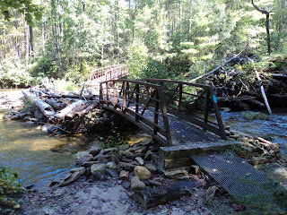
            On the other side of Corbin Creek, the trail curves left and heads for the bank of the Whitewater River. Once you reach the river this time, all of the easy hiking is at your back, and the most difficult part lies ahead.  The trail crosses the Whitewater River on an iron footbridge, but accessing the footbridge requires some boulder scrambling.  The bridge is far better than wading through the river, but this crossing would be much easier had they made the bridge a few feet longer or built some steps to help hikers climb the boulders.
Whitewater River bridge between boulders
            Now on the west side of the river, the trail climbs over a few more boulders before beginning the climb away from the river.  Over the next 0.5 miles the trail gains roughly 400 feet in elevation, so the climb is quite steep.  On the bright side, numerous switchbacks help ease the grade, and 300 wooden steps have been installed to help with footing.  The first switchback takes the trail several hundred feet downstream from the river crossing, but the trend from that point is upstream.
            At 2.9 miles, the Foothills Trail exits left while the trail to the waterfall overlook switches back to the right.  After climbing one final set of wooden steps, you reach the main overlook for Whitewater Falls.  What a sight this is!  The plentiful, clear water of the Whitewater River tumbles 400 to 600 feet (it is hard to measure waterfalls this large) with two large drops, one at the top and one at the bottom.  Green pine trees and grey rock outcrops surround the falls, framing them perfectly.  You have earned this view, so take some time and have a trail snack while savoring the rewards.
Upper Whitewater Falls
            The steps heading further uphill to the left lead to the national forest parking lot mentioned in the third paragraph.  There is no other trail that links Upper Whitewater Falls to the parking lot at the Bad Creek Foothills Trail Access that contains your car, so your options are to retrace your steps along the Foothills Trail or take these steps to the state highway and walk back along the road.  To do the road walk (approximate distance 4 miles), turn left on the state highway, and then turn left again on the Bad Creek Access road you drove in on.  The road walk is much easier but much less scenic than the Foothills Trail, so take inventory of your physical stamina to decide how best to complete this hike.

2 comments:

  1. Hiking on the Foothills Trail this weekend. Thanks for the detailed info!

    ReplyDelete
    Replies
    1. You're welcome. You should have a great time out there this weekend!

      Delete