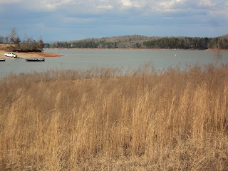
Hike Location: Tugaloo State Park
Geographic Location: northeast of Lavonia , GA (34.49755, -83.07653)
Length: 3.6 miles
Difficulty: 4/10 (Moderate)
Dates Hiked: February 2013, January 2023
Overview: An interesting frontcountry hike with good lake views and wildlife viewing.
Park Information: http://www.gastateparks.org/Tugaloo
Hike Route Map: http://www.mappedometer.com/?maproute=157985
Hike Video:
Directions to the trailhead: In northeast Georgia , take I-85 to SR 17 (exit 173). Exit and enter north on SR 17. In less than 0.2 miles, turn right on Gerrard Road, cross the railroad tracks, then immediately turn right to continue on Gerrard Rd. Drive Gerrard Rd. its entire length to SR 328 and turn left on SR 328. Drive SR 328 3.3 miles to the park entrance road on the right. Turn right on Tugaloo Park Road , enter the park, and park in the blacktop old boat ramp parking lot behind the Visitors Center
The hike: Formed by the confluence of the Tallulah and Chattooga Rivers Tugaloo River Georgia and South Carolina . The word “Tugaloo” comes from the Cherokee Indian name for this particular river. The river’s days of flowing ended with the construction of Hartwell Dam in the 1950’s, and today Tugaloo State Park occupies a hilly peninsula that juts eastward into Lake Hartwell
The most popular activities at Tugaloo State Park
The Sassafras Circle Trail starts at a brown carsonite post to the right of the old boat ramp parking area downhill from the Visitors Center
 |
| Trail enters woods |
After crossing a small stream, the trail traces around a wide sunny peninsula that appears to contain a canoe launch area. Notice the cut made into the hillside to create a level trail surface here and think of the labor it took to build this trail. If rain has fallen recently, look for animal tracks in the soft disturbed soil underfoot. On my visit I saw several sets of deer tracks in this area, and later in the hike I saw a group of white-tailed deer.
After passing some wooden steps that exit right up to an old parking area, you enter a confusing area where the blue carsonite posts are needed to keep you on the trail. The entire Sassafras Circle Trail is well-marked with blue paint blazes and blue carsonite posts, without which parts of this trail would become a real exercise in route-finding.
 |
| Lake Hartwell |
The trail drops through two steep ravines, and in between it rises to cross a narrow paved boat ramp access road. At 1.5 miles, you pass a bench that offers a nice view of Lake Hartwell
 |
| Wooden footbridge |
Upon reaching the main park road, cross the road and walk downhill through a grassy area to reach the southern campground loop. Turn right on this loop, walk up to the next intersection, and then angle left as the trail reenters the woods. Another blue carsonite post and a blue paint blaze mark this point.
 |
| Trail exits campground |
The trail stays on the high ground for a short distance with some white silos to your right before curving left and descending moderately. At 2.7 miles, the two arms of the Muscadine Trail come back together. The Sassafras Circle Trail turns right here while the Muscadine Trail continues straight. Again, follow the blue blazes to stay on the right trail.
 |
| Intersecting the Muscadine Trail |
3.3 miles into the hike, the trail comes out at the primitive campground access road. You need to turn right here and walk along the seldom-used primitive campground access road back out to the main park road, but there are no trail markings here to indicate such. Upon reaching the main park road, cross it and reenter the woods where you will once again find the blue blazes. After a short downhill stint, you close the loop. A left turn and 0.2 miles of retracing your steps will return you to the Visitors Center
No comments:
Post a Comment