Hike Location: Mount Echo Park
Geographic Location: west side of Cincinnati , OH (39.09135,-84.56603)
Length: 1 mile
Difficulty: 6/10 (Moderate)
Difficulty: 6/10 (Moderate)
Dates Hiked: 1999, June 2013
Overview: A short hike to one of the most famous views of Cincinnati .
Park Information: https://www.cincinnati-oh.gov/cincyparks/visit-a-park/find-a-parkfacility/mt-echo-park/
Directions to the trailhead: From downtown Cincinnati , take 6th Street west and exit onto Elberon Ave. Take Elberon Ave. uphill to the park entrance, which is near the top of the hill on the left. The entrance is marked by a small, brown street sign. Turn left and take the main park road past the overlook to a small parking area where the road ends.
The hike: Mount Echo Park Cincinnati that you passed on the way in. However, the park, located at the southern end of Price Hill overlooking the Ohio River, also contains some tennis courts, a playground, several picnic areas, a pavilion, and the short nature trail described here. Before you stand in awe at the view of downtown from the famous overlook at the end of this hike, take a few minutes to get to know the area's natural surroundings that this trail displays.
 |
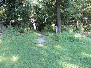
| Trailhead |
The trail now begins a long climb, the only major climb of the hike, up some stone steps. The trail becomes a bit overgrown here, requiring you to bend down underneath some honeysuckles to pass. Once atop the hill, the trail comes out in a mown field. In the future, there may be a trail reentering the woods to the left to take you back to the parking lot, but it was not open when I was here. Thus, you should turn right and begin walking along the paved road that is only a few feet from where the trail exits the woods.
 |
| Downtown Cincinnati, as seen from overlook |
 |
| Ohio River, as seen from overlook |
No comments:
Post a Comment