Tuesday, June 11, 2013

Little Ocmulgee State Park (Blog Hike #231)

Trail: Oak Woods Loop
Hike Location: Little Ocmulgee State Park
Geographic Location: north side of McRaeGA (32.09427, -82.89582)
Length: 1.9 miles
Difficulty: 2/10 (Easy)
Dates Hiked: February 2008, December 2013
Overview: An easy hike exploring the coastal sand hills and surrounding habitats.
Hike Route Map: https://www.mappedometer.com/?maproute=721641
Photo Highlight:

Directions to the trailhead: Between Macon and Savannah, take I-16 to US 319 (exit 51).  Exit and go south on US 319.  Take US 319 28 miles to the park entrance on the right.  Enter the park and pay the nominal entrance fee at the fee station.  Where the lodge road exits right, continue straight, heading for the Visitor Center.  Park in the blacktop parking lot to the right (north) of the Visitor Center.

The hike: Located in the coastal plain some 70 miles southeast of Macon, Little Ocmulgee State Park represents one of south Georgia’s brightest recreation gems.  The centerpieces of the park are the 265 acre lake, which offers a swimming beach as well as boating and fishing opportunities, and the 60 room lodge and conference center capable of hosting a wide variety of events.  Other lodging opportunities include a 55 site campground and 10 cottages available for rent.
            In terms of recreation, while the lake takes center stage, an 18 hole championship golf course, 9 picnic shelters, 2 tennis courts, and a miniature golf course combine to make this a recreation paradise.  Even better, the park’s southern location allows these outdoor recreation options to be used comfortably for most of the year. 
For hikers, the park offers a pair of concentric loop trails that rank among the finest in the region.  The 1.9 mile Oak Ridge Loop and the inner 1.5 mile Magnolia Loop provide very pleasant hikes on wide well-maintained trails.  Combining these trails with the trails at Ocmulgee National Monument in Macon would make a nice full day of hiking through a wide variety of natural habitat and human history.
Trailhead
            The trail begins at a wooden fence and information board at the northwest corner of the parking lot.  A trio of brochures are available at the trailhead.  The yellow brochures describe the Magnolia Loop, the pink ones the Oak Ridge Loop, and the white ones give a park map outlining both trails.  From the information board, the trail heads gradually downhill with the campground to your left.  Soon the trail crosses a small stream on a wooden footbridge.  Notice the tan-colored waters in this stream, and remember that color for later in the hike.
Just after crossing the stream, 0.2 miles into the hike, the trail forks to form the loop.  To travel the same direction as the numbers for the brochures, you will need to turn right here and use the left trail as the return route.  Angling right, the trail climbs gradually through scrubby forest featuring a dense understory of deerberry and sand hickory, among others.  The soft sand underfoot gives this hike very much a coastal feel even though the ocean is over 100 miles away.
Hiking through "coastal" forest
            Continue following the trail as it reaches a clearing atop a small hill.  The numbers on the yellow posts correspond to the trail guide for the Magnolia Loop. After descending the other side of the hill, the trail forks with the yellow-blazed Magnolia Loop heading downhill to the left and the pink-blazed Oak Ridge Loop heading uphill to the right.  If you wanted to short-cut the hike, you could follow the Magnolia Trail here, but to get the full tour, angle right on the Oak Ridge Loop.
Sandy trail in sand hills
            The trail climbs gradually to reach the highest point of the hike.  The sand underfoot has temporarily been replaced by dirt and gravel as the habitat now changes to a more open hardwood forest.  Unlike the sand hills, the firm dirt here allows the trees to grow higher, thus creating a very different environment.  The pink numbered posts now correspond to the brochure for the Oak Ridge Loop.
At the midpoint of the hike, the trail curves left and begins heading gradually downhill back toward the lake.  As you descend, notice a series of five tall dead pine trees on the left.  Vultures and hawks love the sand hills as the heat from the sand helps support them in glide, and on my visit I saw no less than 22 vultures perched on these five trees.  Keep your eyes open and find out how many you see.
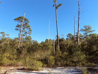
Dead pines
            At 1.2 miles, arrive at the wooden swamp boardwalk which exits right.  Take a few minutes to walk along the boardwalk to get a feel for the swamp environment.  This swamp is man-made, as this area was dry before the Little Ocmulgee River was dammed to create the state park lake.  While the trees near the shore comprise typical floodplain forest, bald cypress trees surround the observation area at the end of the boardwalk, keeping the boardwalk shady most of the year.  Notice the black waters here, a result of the silt build-up from many years, and compare them to the tan-colored water you saw earlier in the hike.  It is hard to tell how deep the water is, but I lowered by staff beyond the side of the boardwalk about halfway to the observation deck and it did not reach bottom.
Swamp boardwalk
            Back on the Oak Ridge Loop, the hike now becomes a lowland hike through floodplain forest, crossing several tributaries of the lake on wooden bridges.  At 1.4 miles, the Magnolia Trail joins from the left, and the combined trails continue south parallel to the lake.  Although the lake is only 100 yards to your right, it is usually not visible through the dense forest.
Returning along the lake
            At 1.8 miles, the trail angles left to close the loop.  A right turn and short uphill walk past the campground is all that remains to return to the parking area and complete the hike.

No comments:

Post a Comment