Trails: Sound and Boardwalk Trails
Hike Location: Bodie Island
Geographic Location: south of Nags Head, NC (35.81783, -75.56475)
Length: 1.3 miles
Difficulty: 0/10 (Easy)
Date Hiked: May 2009
Overview: A pair of short, flat trails exploring the waters near Bodie Island
Lighthouse Information: http://www.outerbanks.com/BodieIslandLighthouse/
Hike Route Map: http://www.mappedometer.com/?maproute=96819
Photo Highlight:
Hike Route Map: http://www.mappedometer.com/?maproute=96819
Photo Highlight:
Directions to the trailhead: From the Whalebone Junction in Nags Head, take SR 12 south 6 miles to the signed entrance road for Bodie Island Lighthouse. Turn right onto the paved entrance road. Park in the large blacktop parking lot in front of the lighthouse at the end of the entrance road.
The hike: Few places south of New England have as many famous lighthouses as North Carolina ’s outer banks. Probably the most famous of these lighthouses is the Cape Hatteras Lighthouse, sometimes also called “America ’s lighthouse” due to its famous black-and-white spiral stripe. In times past southbound merchant ships would sail near the coast to take advantage of powerful countercurrents to the northward flowing Gulf Stream , putting them in danger of running aground on rocky shoals. These lighthouses steered ships away from the most dangerous shoals.
Today the lighthouses on the outer banks serve mainly as tourist attractions, though some are still technically operational. During the summer months, tourists tend to overrun the Outer Banks, turning the area into yet another overcrowded tourist trap not unlike many of the other popular vacation spots in the eastern United States . I visited in early May before the crowds arrived, and my trip to the Outer Banks could not have been more pleasant.
For people visiting the Outer Banks not wanting to make the drive all the way down to Cape Hatteras Lighthouse, the Bodie Island Lighthouse makes an excellent and nearby substitute. Unlike Cape Hatteras Lighthouse, Bodie Island Lighthouse is not open for climbing. However, Bodie Island Lighthouse has two things its taller, more famous cousin does not: a pair of easy nature trails that allow visitors to explore the area around the lighthouse. These trails comprise the hike described here.
A visit to the lighthouse grounds should start with a trip to the Visitor Center
 |
| Bodie Island Lighthouse |
The boardwalk leads 1000 feet to a wooden overlook platform that stands near a small pond surrounded by marsh. This platform gives a great view of the wall of sand dunes protecting the beach to the east. It is also a great place to do bird watching, as several small stands of trees can be seen to the south, north, and west. On my visit, I saw some egrets and geese in the pond and an osprey in the trees to the south.
 |
| Marsh at end of lighthouse boardwalk |
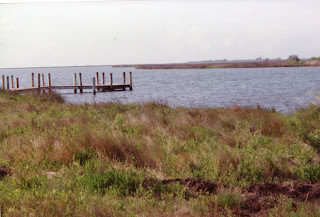
0.25 miles from the vehicle gate, the trail crosses a creek as it curves to the right. Still water like this makes for plenty of mosquitoes, so be sure to put on several layers of insect repellent before heading into the marsh. At 0.3 miles, you will reach the end of the gravel road at the edge of Roanoke Sound. From this point, you can look up and down Roanoke Sound and see only a small amount of human interference. A couple of buildings wrecked by a hurricane can be seen on the shore, and the US 64 bridge can be seen 6 miles to the north. If you come late morning you will likely be alone: the fishermen who use this point as a boat launch leave early in the morning and return in the afternoon. How often do you get so much solitude at such a great body of water for so little effort?

No comments:
Post a Comment