Thursday, June 6, 2013

Fort Hill Earthworks and Nature Preserve: Gorge and Fort Trails (Blog Hike #84)

Trails: Gorge and Fort Trails
Hike Location: Fort Hill Earthworks and Nature Preserve
Geographic Location: southeast of HillsboroOH (39.12153, -83.39665)
Length: 4.6 miles
Difficulty: 10/10 (Difficult)
Dates Hiked: November 2000, June 2013
Overview: A rugged course along Baker Fork followed by a steep climb to the fort.
Hike Route Map: https://www.mappedometer.com/?maproute=940204
Photo Highlight:

Directions to the trailhead: From Hillsboro, drive US 50 east 9.4 miles to SR 753 and turn right on SR 753.  Take SR 753 south 7.1 miles to SR 41 and turn right on SR 41.  Drive SR 41 south 0.6 miles to Fort Hill Road, a narrow, paved road that goes off on the right.  Turn right and drive 1.6 miles to the state memorial entrance on the left.  Park on the right side of the second and last parking lot.

The hike: Located in rural, rugged southeastern Highland County, Fort Hill State Memorial features one of the best preserved Indian earthworks in the entire state.  It is believed the ceremonial fort was built between 300 B.C. and 600 A.D. by the Hopewell culture.  John Locke, a pioneer geologist of the early 1800's, became the first white man to document the fort's features in his 1838 work "Second Annual report on the Geological Survey of the State of Ohio." 
            In 1932, the state of Ohio took advantage of an opportunity to purchase 237 acres containing the fort.  1000 additional acres have since been purchased to yield the current memorial.  In 1968, a museum was built along the entrance road to interpret the fort's archaeological significance.  The museum is open March through October.
            The memorial is accessed by three concentric, interconnecting trails.  The red-blazed Fort Trail is the shortest and easiest at 2.3 miles in length.  This trail climbs 400 feet and loops around the top of Fort Hill, where the fort is located.  It makes a good alternate for those unable to undertake more challenging hikes. 
            The route described here uses part of the Fort Trail and part of the yellow-blazed Gorge Trail, a 4.0-mile trail that loops around the base of Fort Hill.  The outer-most loop is the 5.3 mile blue-blazed Deer Trail.  Suited for the more conditioned and adventuresome, the Deer Trail is an extremely difficult trail over three hills with several steep sections.  I note that all three trails involve steep climbs and caution regarding your ability and trail conditions should be exercised.  An outline and drawing of the trails can be found at the information kiosk at the trailhead.           
Information kiosk at trailhead
            With the disclaimers out of the way, let's get hiking!  From the information board, go right through a grassy area where the combined Deer and Gorge Trails enter the woods.  Watch for the yellow markings of the Gorge Trail to guide your way.  For the first 2.5 miles, the trail generally parallels Baker Fork on the right with Fort Hill looming to the left.  The trail rises and falls twice to cross two arms of Fort Hill.  The first climb is gradual, but the second one steeper. 
           
Baker Fork
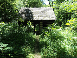
            Finally, descend steeply to arrive at creek level.  The trail passes through a mature beech-maple forest with a very thin understory.  In the winter, watch for ice on this part of the trail, now on the shady north side of Fort Hill.  After crossing two tributaries, the trail rises slightly to reach a trail junction.  The Deer Trail departs to the right to cross Baker Fork on stepping stones.  Our trail continues by angling left and passing through (literally) a restored log cabin. 
           
Restored Log Cabin
            Past the cabin, the trail stays on the south side of Baker Fork, alternating between creekside and bluff.  This section of trail gives good views of the towering exposed dolomite formations along the creek.  If you are to see the small, rare Sullivantia plant attached to the side of the rock, this is the place. Fort Hill has an unusual rock composition.  The base consists of dolomite, which can be seen along the creek.  Further up, the next layer consists of Ohio Black shale, a soft flaky rock that can be seen on the climb to the fort.  The hill is capped by the sandstone that was used to build the fort.  Keep your eye out across the creek, as you will see a pair of natural bridges cut into the hillside.  The second one has an opening about 40 feet tall and 10 feet wide. 
           
Small natural bridge 
Towering dolomite outcrop
            Just past this second bridge, the Deer Trail rejoins from the right.  Cross two more steep bluffs with more exposed dolomite, then take a left turn away from the creek along a tributary.  The trail climbs gradually with more exposed dolomite on either side.  Look for a natural arch to the right of the trail.  Arches differ from bridges in terms of their geologic formation.  Natural bridges are created by water flowing through rock and carving out the opening.  Arches are formed by chunks of rock breaking off, leaving the arch behind.
            The trail takes a sharp right to join an old road, then a sharp left where the Buckeye Trail continues straight.  Watch for the yellow blazes.  Climbing gently, you soon come to another trail intersection where the Deer Trail exits to the right.  Stay left on the Gorge Trail and begin a long moderate climb up Fort Hill.  Over the next 0.3 miles the trail gains 200 feet in elevation to arrive at a junction with the Fort Trail.  To view the fort, turn left on the red-blazed Fort Trail.  The trail maintains a constant elevation as it traces the west side of Fort Hill.  Notice the peaks and valleys in the fort wall, visible uphill and to the right, which look like turrets in a castle.
Final ascent to fort
            At the northwestern corner of the hill, the trail turns right and begins a short, but very steep final ascent to the fort.  After passing through the fort wall, the trail assumes a level, eastward course through mature forest.  In the winter when the trees are leafless. Reeds Hill and Jarnagans Knob can be seen to the left. 
           
Fort earthworks
View from View Point
            On the east end of the fort the trail arrives at View Point, which offers nice views of the surrounding hills and valleys of the Appalachian Plateau.  From here, the trail turns right and passes through the fort wall to leave the fort.  Only a 400-foot vertical descent on switchbacks to the parking lot remains to finish the hike.

No comments:

Post a Comment