Hike Location: Edge of Appalachia Preserve, E. Lucy Braun Lynx Preserve
Geographic Location: east of West Union , OH (38.76726, -83.41174)
Length: 1.5 miles
Difficulty: 3/10 (Easy/Moderate)
Dates Hiked: June 2004, October 2015
Overview: An easy walk along a narrow trail through numerous prairie openings.
Preserve Information:
Hike Route Map:
On The Go Map
On The Go Map
Photo Highlight:

Directions to the trailhead: From West Union, head east on SR 125. Take SR 125 8.2 miles to Tulip Road (in the town of Lynx ). Turn right on Tulip Rd. Take Tulip Rd. south 0.8 miles to Cline Road . Turn left on gravel Cline Road. The preserve's gravel parking area is 0.7 miles ahead on the left.
The hike: The
vast Edge of Appalachia Preserve in southern Adams County Appalachian Mountains . All three trails are described in this blog. The Buzzardroost Rock Trail travels
through succession forest to a view rivaling any in Ohio . The Wilderness Trail leads
past forested dolomite cliffs and through a white cedar community, an unusual
site in climates this warm.
The Lynx Prairie Trail described here completes the trio. This trail is
by far the shortest and easiest of the three, but it takes a little more nuance
to appreciate the prairie habitat than it does to enjoy an outstanding view or some
tall, vertical cliffs. Those who succeed will find that this trail
provides perhaps the best and most extensive examples of prairie openings in
greater Cincinnati . Just keep your eyes open, and see what natural
and living wonders are there to be seen.
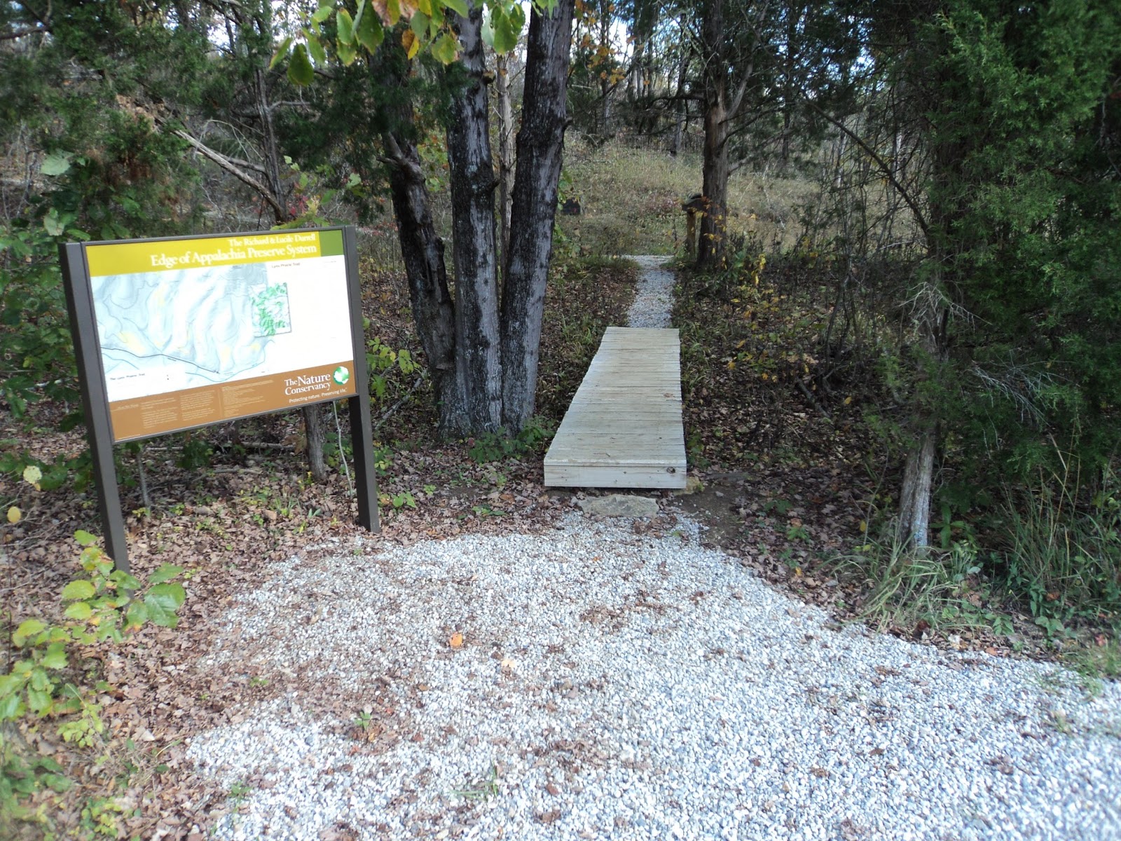 |
| Trailhead at Lynx Prairie |
From the
signed trailhead on the preserve’s south side, the trail crosses a small creek
before curving left to head gradually uphill.
This entrance trail is the newest trail at Lynx Prairie, and it replaces
the old entrance trail that approached the prairies from an abandoned trailhead
on the other (north) side. The initial
segment of trail passes through young maple forest with grassy understory, but
a couple of prairie openings can be seen through the trees on the right. After curving left, the trail crosses the
same small creek on another wooden footbridge before continuing the gradual
climb.
At 0.3
miles, you reach the trail intersection that forms the loop portion of the
hike. This trail description will turn
right to hike the loop counterclockwise.
In fact the “loop” is comprised of three short loops that provide access
to the prairie openings. In the order
you will encounter them, the loops are the Red, White, and Green Loops. Thus, you are currently hiking on the Red Loop.
 |
| Climbing through young forest |
The
gentle climb through more young maple forest continues as you head north along
the loop’s eastern arm. The other arm of
the Red Loop exits left, then the White and Green Loops exit left. These exits leave you on the Green Loop, the
northern-most loop. As you approach North
Prairie, the abandoned trail that led north to the old trailhead can be seen to
the right.
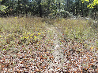
Curving left, the Green Loop heads south through Dock Prairie, which is named
for the large amount of prairie dock that grows here. Look for plants about 1 foot high with a
single large, green leaf. Dock Prairie is the largest of the prairie
openings, and the lack of trees makes it much easier to spot songbirds here
than in the forest. Also, insects such as dragonflies and damselflies
like the plants and sunlight of the prairie.
|
| Hiking through a prairie opening |
0.8 miles into the hike, arrive at the intersection of the Green and White Loops.
The Green Loop exits left and becomes overgrown before closing, so you should continue
straight to begin the White Loop. The White Loop descends gently.
None of the trails are well-marked, but you will find an occasional blaze
nailed to a tree just over head-high.
At another intersection, follow a sign that tells you to turn left to continue
on the White Loop. The trail reenters the young forest, crosses a small
stream, and ascends moderately to arrive at a junction with the Red Loop, which
goes to the right. Turn right, then immediately take another right to
begin traveling counterclockwise on the Red Loop, the southernmost of the three
loops.
The Red Loop descends gently through Narrow Prairie, which gets its name from
its elongated dimensions. The Red Loop traverses Narrow Prairie
lengthwise, then curves left to pass through Annette’s Prairie, the smallest of
the prairie openings on this site. The trail curves left again and begins
climbing, passing a rock ledge on the left that looks out of place in the
prairie. 1 mile into the hike, you close
the loop where the entrance trail exits right.
Turn right and retrace your steps gently downhill to the parking area to
complete the hike.
Update: The Nature Conservancy has built a new trailhead that accesses the preserve from the south, not from the north as described here. To reach the new trailhead, continue south on Tulip Rd. to Cline Rd. Turn left on Cline Rd. and follow the gravel road to its end. The parking and trailhead are on the left. You can no longer access the preserve from the trailhead described here. I will update the trail description for this change in a couple of weeks.
ReplyDeleteThe trail description is now updated to reflect the new trailhead and entrance trail.
Delete