Hike Location: Edge of Appalachia Preserve, Charles A. Eulett Wilderness Preserve
Geographic Location: east of West Union , OH (38.77938, -83.41760)
Length: 2.3 miles
Difficulty: 7/10 (Moderate/Difficult)
Dates Hiked: June 2004, October 2015
Overview: A difficult woodland trail over steep terrain featuring dolomite cliffs.
Trail Information: https://www.nature.org/en-us/get-involved/how-to-help/places-we-protect/edge-of-appalachia-the-wilderness-trail/
Hike Route Map:
On The Go Map
On The Go Map
Photo Highlight:

Directions to the trailhead: From West Union, head east on SR 125. Take SR 125 7.6 miles to Lynx Road and turn left on Lynx Road . Take Lynx Road east 0.4 miles to Shivener Rd. and turn left on Shivener Rd. Shivener Rd. shortly becomes a gravel road. Take Shivener Rd. north 0.6 miles to the gravel pull-out on the left. Just past this pull-out, a wire fence blocks access to the Museum Center
The hike: Have you ever heard of the Adams County Cincinnati Museum Center Museum Center Cincinnati , the Museum Center
This trail passes through a portion of the preserve known for many years as “the Wilderness.” After a visit to this area in 1961, a famous Ohio botanist called the area a “howling wilderness,” and since then the name has stuck. Actually, the terrain is no more harsh than that at Buzzardroost Rock located just a few miles down the road. As with that hike, this trail should only be attempted by those in decent health, as some difficulty will be encountered, especially on the trip back uphill to the trailhead.
 |
| Trailhead: The Wilderness Trail |
 |
| Descending on The Wilderness Trail |
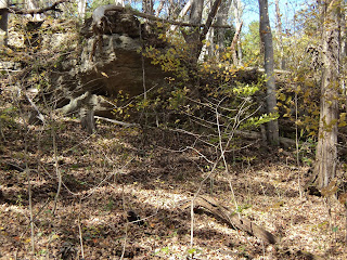
Continuing downhill, the trail passes over a shallow rock shelter (which can be seen underneath you to the left) and some dolomite cliffs visible through the trees uphill to the right. 0.75 miles into the hike, after finishing the steepest descent of the hike, the trail curves right and levels out at an elevation about 175 feet below where you started. The forest here is very young with lots of sunlight reaching the floor, allowing a thick stand of paw paw bushes to grow in the understory.
|
| Dolomite cliffs |
The trail now follows the north side of the ravine and begins the most difficult climb of the hike, gaining 120 feet of elevation in about 0.2 miles. More dolomite cliffs can be seen to the left. At the top of the steepest section, the trail turns right, crosses a stream on a wooden footbridge, and begins a more moderate climb out of the head of the ravine.
2.3 mile into the hike, the trail comes out at a small prairie opening that is also used as a power line swath. Notice the warmer environment of the prairie opening and the different kind of plants and insects that this environment supports. The trail narrows as it climbs through the prairie and reenters the forest on the other side.
 |
| Small prairie opening |
No comments:
Post a Comment