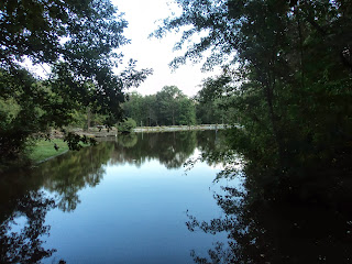
Trails: Perimeter and Victoria Path Trails
Hike Location: Victoria Bryant State Park
Length: 4.1 miles
Difficulty: 5/10 (Moderate)
Dates Hiked: March 2007, October 2013
Overview: A moderate hike through young forest featuring plenty of up and down and good wildlife viewing opportunities.
Park Information: https://gastateparks.org/VictoriaBryant
Directions to the trailhead: From the town of Royston in northeast Georgia , take US 29 south 3 miles to SR 327. Turn right to head north on SR 327. You will reach the state park entrance in 1 mile; turn left to enter the park. Park in the very first parking lot on the left, which is reached right before reaching the fee station. If this lot fills up, an alternate starting point is at the picnic area on the left just after passing the fee station.
The hike: Located on the geological border between the north Georgia mountains to the north and the rolling Piedmont to the south, tiny 485 acre Victoria Bryant State Park Georgia ’s state park system, the prospects for hiking look bleak. Fortunately, such is not the case, and the park offers several good hiking opportunities to complement the park’s main attractions of golfing, fishing, and picnicking.
Three hiking trails allow one to view the park in its natural setting. The 3.5 mile Broad River Trail (described elsewhere in this blog) takes the hiker on a journey through the park’s backwoods (behind the golf course, actually) and offers views of some nice riverside habitat. For those who have less time or energy, two other trails remain near the park’s developed areas. The short 0.5 mile Victoria Nature Path take visitors on a lush streamside walk along Rice Creek. On the other hand, the 2.5 mile Perimeter Trail gives views of the ridges that differentiate this area from the Piedmont just to the south. Using connector trails, these two trails can be combined for the pleasant 4.1 mile hike described here.
 |
| Pond near trailhead |
Cross the parking lot and angle right to arrive at a newly constructed wood and steel footbridge over Rice Creek. The Department of Natural Resources has recently spent significant amounts of money and human resources to upgrade the park’s facilities in general and the trail system in particular, so make sure you visit soon to take advantage of these upgrades. Across the bridge, climb a wooden staircase, also newly constructed, to arrive at a picnic area access road. A nice 10-foot waterfall in Rice Creek can be seen below you and to the right. Turn right on this road, and you will soon arrive at Bryant’s Pond, a small fishing pond for use by campers and an alternate starting point for this trail.
 |
| Hiking the Perimeter Trail |
 |
| Descending on the Perimeter Trail |
 |
| Wildlife opening |
 |
| Crossing Rice Creek |
The Perimeter Trail continues to head north, assuming a rolling track over the high ground. Soon the golf course comes into view on the left. While there are no physical barriers to prevent you from walking out on the golf course, to avoid flying golf balls, you should choose to stay on the trail in the woods.
 |
| Hiking near the golf course |
To return to the trailhead, on the near bank of Rice Creek, pick up the green-blazed Victoria Path Nature Trail, which heads into the woods on the left side of the paved campground road. This trail with its narrow treadway and the lush doghobble near the creek provides a stark contrast to the Perimeter Trail. Rice Creek can almost always be seen and heard, and several cascades make for especially scenic spots. A little scrambling over bare rock will lead you to the main park road at 3.7 miles.
While the park road fords Rice Creek, you should remain on the left side of the creek and begin climbing along the park road, choosing the road closest to the creek. About half way up the hill, angle right on an unmarked trail that heads back toward the creek. Cross a wooden footbridge and dodge a few more rocks to arrive at an overlook platform of a nice 10-foot waterfall in Rice Creek. After you have taken in the scenery, continue up the park road to return you to the fishing pond trailhead and complete the hike.
No comments:
Post a Comment