Trails: Sulpher Springs Loop and Fire Tower Trails
Hike Location: Paris Mountain State Park
Geographic Location: southeast of Travelers Rest, SC (34.93651, -82.38686)
Length: 4.9 miles
Difficulty: 9/10 (Difficult)
Date Hiked: September 2011
Overview: A mountain hike with several difficult sections and a side trip to a former fire tower site.
Park Information: https://southcarolinaparks.com/paris-mountain
Hike Route Map: https://www.mappedometer.com/?maproute=723732
Photo Highlight:

Hike Route Map: https://www.mappedometer.com/?maproute=723732
Photo Highlight:

Directions to the trailhead: On the north side of Greenville , take US 25 to State Park Road ; there is a traffic light, Wal-Mart, and Paris Mountain State Park State Park Road . Take State Park Road 9 miles to the signed state park entrance on the left. Take a soft left to enter the park. Pay the nominal entrance fee and remain on the park’s only road as it passes the campground entrance on the left. This trail description starts at the Archery Trailhead, which is located on the right 2.2 miles from the park entrance or 0.3 miles past picnic shelters 5 and 6.
The hike: Many first-time visitors to Paris Mountain State Park Paris Mountain Greenville with a reliable source of water, engineers built a dam on Mountain Creek on the side of Paris Mountain Greenville .
To preserve the purity of the water supply, the forested ravine of Mountain Creek was preserved in its natural state. In the 1930’s, a fire tower was built atop Paris Mountain Lake Placid , one of those reservoirs, today serves as the park’s swimming lake during the summer months.
Since the 1930’s, modern picnic and camping facilities have been added, but much of the park remains in its preserved natural state. 13 miles of trails allow hikers and mountain bikers to explore the natural and historic sites. The 3.5 mile Sulpher Springs Loop featured here includes a trip to the 1890’s dam mentioned above and gives the opportunity to add the short 0.4 mile spur trail to the remains of the historic fire tower. Be aware that this is a fairly challenging hike: it took me nearly 3 hours to complete this loop.
There are several places from which you can access the Sulpher Springs Loop. The most obvious access is from picnic shelters #5 and #6, but those parking lots were full on my Saturday morning visit. Alternatively, you could start at the Brissy Ridge trailhead at the highest point of the park road, but that leaves the hardest climbing until the end of the hike. To avoid both of these troubles, I recommend starting at the seldom-used Archery trailhead, which is located about half-way up Paris Mountain at a small parking lot on the right side of the park road.
 |
| Beginning the Sulpher Springs Loop |
The Archery trailhead gets its name from a 1936 CCC-constructed archery range that used to sit just downhill from here. An interpretive sign at the trailhead contains information and a picture of the old archery range. Begin by hiking down the short spur trail and, in only 200 feet, reach the Sulpher Springs Loop, which goes right and left. To get the hardest climbing out of the way first, I suggest turning left here and hiking the loop counterclockwise.
The white-blazed trail drops to cross a small creek on a wooden footbridge before beginning to climb steeply. Over the next 0.4 miles the trail gains 380 feet in elevation. This section of the trail is open to mountain bikes 6 days of the week (every day except Saturday), so the climb though steep is manageable with only your feet rather than your feet and hands.
After huffing-and-puffing your way up the first 0.7 miles, you reach a flat wide spot in the trail at the top of the knob. This point is neither the highest point on the mountain nor the highest point on this hike, but it is substantially higher than the surrounding terrain and thus gives you a top of the world feeling. Unfortunately, a dense canopy of broadleaf trees allows no views.
 |
| Top of knob |
For the next mile the Sulpher Springs Loop follows the old fire tower access road as it gradually gains elevation. The wide two-track roadbed makes the going very easy. The steep ravine to your left the entire time is the Mountain Creek ravine where you will be shortly.
 |
| Double white blaze-exit old road |
At 1.9 miles, a double white blaze indicates that the Sulpher Springs Loop turns left to exit the old road. We will eventually take the single-track trail blazed in white, but to visit the old fire tower site, take the blue-blazed Fire Tower Trail which continues straight on the old access road. A spur trail exits right for the Kanuga Trail just before the grade steepens slightly to reach the top of Paris Mountain
At 2.3 miles, you reach the trail’s end. The fire tower site is just through the woods uphill to your right. Nothing of the 80-foot steel tower remains, but the stone foundation and brick chimney of the tower-keeper’s house can still be easily seen. This tower only operated for a few years: the real summit of Paris Mountain
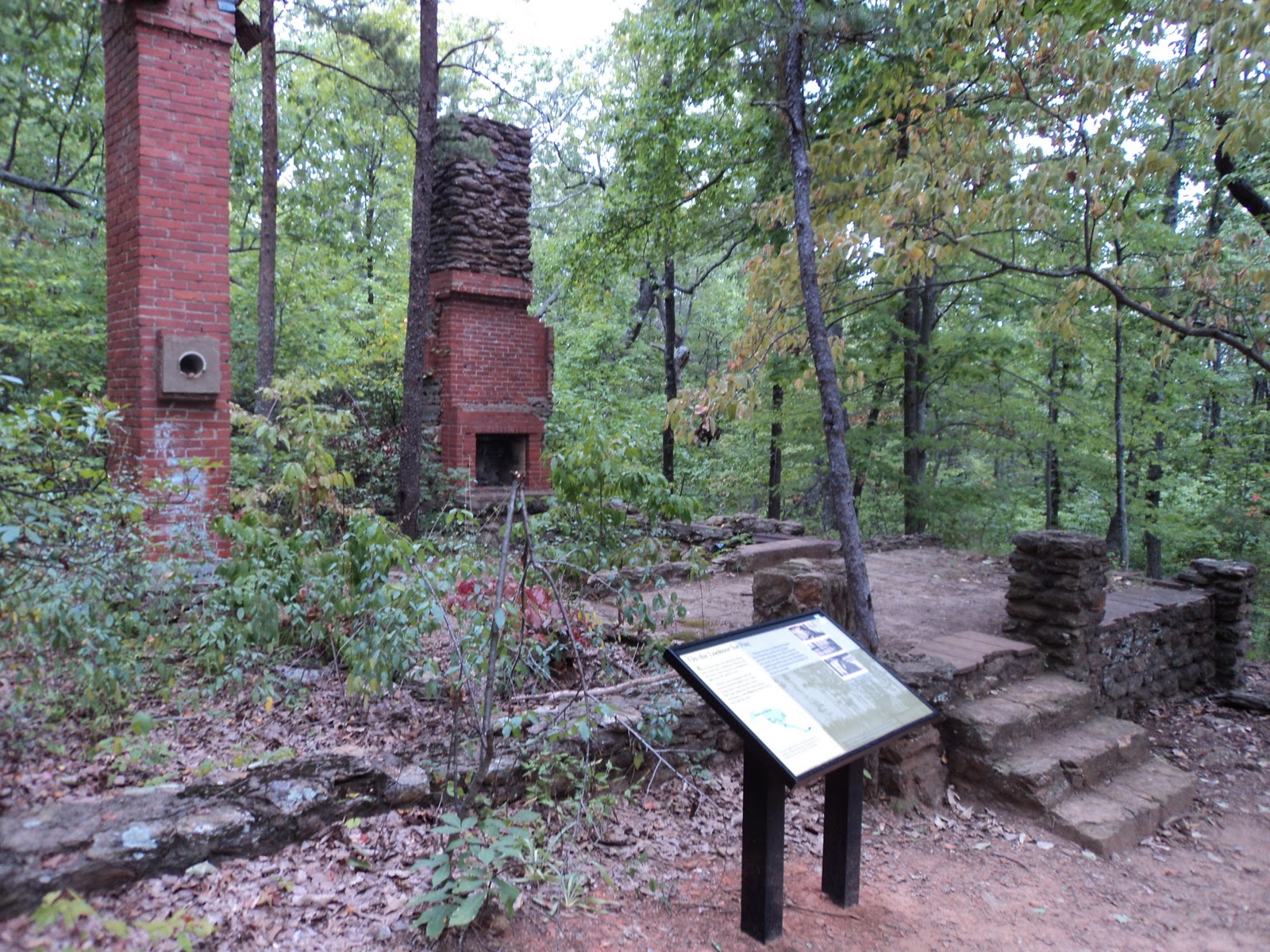 |
| Fire tower keeper's house |
The Fire Tower Trail ends at the old tower site, so you next need to retrace your steps to the Sulpher Springs Loop. Take a sharp right to leave the old road and continue the loop. The next section of trail through the upper reaches of Mountain Creek’s ravine is hiker-only all the time and is rated as the most difficult trail in the park. You may not see why it earned this rating at first, but you will eventually.
The trail descends moderately via a single switchback formed by a recent trail relocation. As you approach Mountain Creek itself, rhododendron fills the understory, and the descent becomes very steep and rocky. After descending some steps cut into the bedrock, you will need to rock-hop the creek just below an attractive 10-foot waterslide.
 |
| Small waterslide |
Now on the west side of the creek, the steep rocky descent continues relentlessly. For most of the descent you can keep yourself upright with just your feet, but a couple of areas will likely force you to use your hands for additional friction and balance. Shortly after passing through a rather large rhododendron-filled hollow, you pass a small waterfall in the creek located under a small boulder.
 |
| Mountain Lake |
3.6 miles into the hike, you reach the beginning of Mountain Lake Greenville . At 3.7 miles, the trail forks. The wide trail exiting at a soft angle to the left leads to the park road but not to the Archery Trailhead. Thus, you should stick with the white blazes and head down the stone steps to the right to reach the dam. Take a minute to study the somewhat unusual dam: the chiseled stones forming the dam are joined together by metal braces, and the spillway is located in the middle of the dam.
 |
| Stone dam |
|
| Structure containing valve |
The trail continues descending past the dam to reach the remains of the cylindrical stone structure that housed the dam’s valve mechanism. One of the pipes that carried water to Greenville can still be seen on the ground just below this structure. The hardest hiking is now behind you as the trail continues descending on a very gradual grade alongside the creek, passing a small shelter along the way.
At 4.2 miles, the trail comes out at picnic shelters #5 and #6. To continue the loop, turn left, cross the main park road, and reenter the woods at a brown wooden sign that reads, “Sulpher Springs Trail.” The trail climbs moderately to reach a T-intersection where the Mountain Creek Trail exits to the right. Turn left to remain on the Sulpher Springs Trail. The gradual to moderate climb continues until, at 4.8 miles, you arrive back at the signed spur trail to the Archery Trailhead. A left turn and 200 feet of uphill walking will return you to the trailhead and complete the hike.
No comments:
Post a Comment