Tuesday, June 11, 2013

High Falls State Park: Falls Trail (Blog Hike #207)

Trail: Falls Trail
Hike Location: High Falls State Park
Geographic Location: north of ForsythGA (33.18005, -84.01807)
Length: 1.1 miles
Difficulty: 4/10 (Moderate)
Dates Hiked: November 2006, December 2013
Overview: An occasionally rocky hike featuring the High Falls on the Towaliga River.
Park Information: https://gastateparks.org/HighFalls
Hike Route Map: https://www.mappedometer.com/?maproute=720639
Photo Highlight:

Directions to the trailhead: Between Atlanta and Macon, take I-75 to High Falls Road (exit 198).  Exit and go east on High Falls Road.  2 miles east of I-75, you will cross a bridge over the Towaliga River.  The trailhead is located on the right immediately after crossing the bridge.  There is no parking at the trailhead, so you will need to turn left into the camping area, park near the picnic shelter or the restrooms, and walk back to the trailhead.

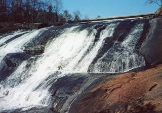
The hike: While one would think that a large, attractive waterfall, such as the High Falls on the Towaliga River, located between two of Georgia’s largest cities would always have been a mecca for tourists, such is not the case.  In fact, the Towaliga River has a working and occasionally bloody history.  The name “Towaliga” comes from a Creek Indian word meaning “roasted scalp.”  According to legend, in the 1800’s the Creeks were returning from a massacre of a nearby settlement when, knowing the scalps obtained from the massacre would spoil in the hot Georgia summer, they stopped at this river to dry or smoke them.
Fortunately, future settlement of this area was more successful than these first settlers.  By the mid-1800’s, a grist mill was built on this site.  The original mill was destroyed during the Civil War, but a new one was built in 1866, and it would remain in operation for 94 years.  In 1890, construction began on the dam you see today.  The dam was completed in 1904, and it provided electric service to the town of High Falls and the nearby cotton mills.  The building that housed this power plant can still be seen today on the west bank of the river below the falls.  In 1958, the power plant was closed, and the land transferred to the Hiawassee Timber Company.
In 1966, the lake and some surrounding land were donated to the State Parks Department, and High Falls State Park was created.  Additional acquisitions bring the current total to 998 acres.  The centerpiece of the park remains the falls, though a pair of campgrounds and a few picnic shelters also attract visitors.  For hikers, there are two main trails.  The Tranquil Trail, described elsewhere in this blog, takes visitors on a nice 2.5 miles hike through second-growth forest of various degrees of maturity.  The 1.1 mile Falls Trail described here takes visitors to the highlight of the park, the High Falls on the Towaliga River.
Trailhead: Falls Trail
            Begin at a red information board beside a pair of benches at the gravel-paved trailhead.  The trail leaves this area, heading downhill with the river behind a wooden railing on the right.  This descent is made over a combination of bare rock and wooden steps.  I imagine these rocks get slippery when wet, so watch your footing.
Towaliga River above waterfall
            In only 0.2 miles, you will reach an overlook platform consisting of bare rock at the base of the falls.  This platform gives a broad, unobstructed view of the rocky, noisy 100-foot waterfall.  The waterfall looks similar to most other spill-over waterfalls in the eastern United States, but the volume of water and this waterfall’s location make this a popular site and make it unlikely you will be the only person admiring the falls.
High Falls, from the side

High Falls, from the base
            Past the waterfall, the trail assumes a more normal single-track dirt course.  The trail is marked with red blazes painted on trees to ensure you will not get lost.  The trail descends gently, and the river can be heard but usually not seen on the right.  At 0.4 miles, you arrive at a trail intersection.  The Falls Trail is organized as a double loop.  Continuing straight will lead you along the northern loop and back to the trailhead in only 0.4 miles.  To hike the entire Falls Trail, you will need to turn right here, cross a sturdy wooden bridge, and hike the southern loop as well.  In only 100 feet, you will come to a bench and an intersection that marks the beginning of the southern loop.  To stay near the river longer sooner, this description will angle right here and use the left trail as the return route.
The trail maintains a fairly level course through young floodplain forest with the river on the right.  Where side trails depart to the river, stay on the main trail by following the red blazes.  At 0.5 miles, the trail drops to pass through a small collection of boulders right along the river bank.  Past the boulders, the trail climbs moderately and abruptly switches back to the left; watch the blazes so you do not miss this turn.
The trail climbs gently, now well upslope from the river.  Nice views of the entire river valley open up to the left during the leafless months.  At 0.6 miles, the trail drops to cross a rocky creek without the aid of a bridge.  This crossing could be tricky, but should be manageable is you watch your step.  Next, the trail curves to the left and descends moderately to return to the bench and close the southern loop.  Angle right and cross over the bridge a second time to reconnect with the northern loop.
Returning in the upland
            Turn right to continue the northern loop, which heads up a steep ravine.  Using a pair of switchbacks, the trail climbs out of the ravine, treading around a small rock outcrop and gaining 100 feet of elevation over the next 0.2 miles.  With the heavy climbing over, the last 0.2 miles of trail leads through dry, open, ridgetop forest over a gentle grade.  One final sharp left turn will return you to the trailhead and complete the hike.

No comments:

Post a Comment