Hike Location: Cincinnati Nature Center
Geographic Location: northwest of Batavia , OH (39.12551,-84.24594)
Length: 2 miles
Difficulty: 5/10 (Moderate)
Dates Hiked: 1999, August 2017
Overview: A wonderful, moderate, short hike featuring a lake, a rock outcropping, and two waterfalls.
Park Information: https://www.cincynature.org/
Directions to the trailhead: On the east side of Cincinnati , take I-275 to exit 63B, which goes onto SR 32 east. Take SR 32 east for 1.2 miles to Glen Este-Withamsville Road (the first traffic light) and turn left. Follow this road north 0.4 miles to Old SR 74 and turn right. Take Old SR 74 east for 0.25 miles and turn left onto Tealtown Rd. The Cincinnati Nature Center Tealtown Rd. on the left. A large "Rowe Woods" sign marks the entrance. Pay the small parking fee and proceed to the main parking lot in front of the interpretive building, where our hike will begin. A second gravel parking area is available to the right of the main parking area, should the main area be full.
The hike: The Cincinnati Nature Center
The nature preserve (named Rowe Woods after Mr. Stanley M. Rowe, a major benefactor of the Center) features 14.5 miles of well-marked and well-maintained trails over a diverse 790 acres of forest, creeks, hills, meadows, and ponds. The Lookout Trail alone (described elsewhere in this blog) will take you past each of these ecosystems. Before you begin, be sure to stop in the Rowe Interpretive Center
The route described here is one of the most scenic short hikes in greater Cincinnati . There is more to see in these 1.9 miles than on most trails twice as long. This route is beautiful all year long, but it is especially nice during the wet season when its two waterfalls are in top form. Avey's Run is a small stream, and I suspect that the waterfalls dry up during a summer drought. Be sure to wear some insect repellent, as the deep woods and still water are perfect for mosquito spawning.
 |
| Start of Edge Trail near Rowe Building |
 |
| Hiking along Powell Crosley Lake |
The trail next turns to the right and crosses a drainage before coming to marker #3, a trail intersection. Trail intersections at Rowe Woods are marked by small three-inch concrete cylinders with green and white numbers. Ignore the trail that goes left here and continue straight, shortly reaching a shelter house overlooking the lake. There was a couple feeding some bread to four Canadian geese on the day I was here. Feeding wild animals is generally not a good idea. As animals become used to receiving handouts from humans, they expect each hiker passing by to give them some food to eat. This results in a lower ability to survive in the wild and more aggressive behavior around people.
 |
| Powell Crosley Lake |
 |
| Small waterfall in Avey's Run |
 |
| Hiking along Avey's Run |
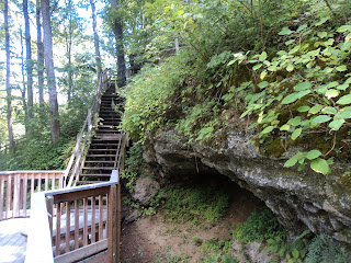
Just past the shelter, come to a trail intersection with wooden steps descending both to the right and the left. Turn left here to view Fox Rock, a small limestone outcrop reached via a steep set of wooden steps and a boardwalk, allowing you a great view from just a couple feet away from the outcrop. Be careful as you descend the narrow steps. The boardwalk ends at the end of the outcrop, forcing the hiker to backtrack to the trail intersection mentioned above.
 |
| Fox Rock |
Turn right to begin the return portion of this hike. Pass marker #9 and enter the streamside forest. The streamside forest is dominated by maple and beech trees, and honeysuckle seems to grow just about everywhere. The trail meanders to the right to follow alongside the creek. After a couple hundred feet, the trail crosses the creek on stepping stones, only to recross it again in 100 feet. Originally, the trail remained on the north side of Avey's Run, but a landslide in 1974 forced this short section of the trail to be moved to the opposite bank. Again, during times of very high water, the stepping stones may be submerged, and some wading may be required.
 |
| Old pump house |
Pass marker #7 before coming to marker #6 where the Fox Rock Trail comes in from the right, thus closing the loop. Retrace your steps up the hill for the last major climb of the hike. This returns you to the Edge Trail. Turn left, pass a well-placed bench and a wooden pier before coming to the boardwalk. This boardwalk takes you out into Powell Crosley Lake
No comments:
Post a Comment