Hike Location: Red Rock Canyon National Conservation Area
Geographic Location: west of Las Vegas, NV (36.13489, -115.42768)
Length: 2 miles
Difficulty: 4/10 (Easy/Moderate)
Date Hiked: May 2006
Overview: A fairly flat hike through classic Mojave desert country.
Area Information: http://www.redrockcanyonlv.org/
Directions to the trailhead: On the west side of Las Vegas, take I-215 to West Charleston Boulevard (SR 159). Exit and go west on SR 159. Take SR 159 west 8 miles to the entrance to Red Rock Canyon National Conservation Area. Turn right to enter the area. Follow the signs to the Visitor Center, and park in the Visitor Center parking lot.
The hike: Most people visit Las Vegas for the entertainment, dining, and shopping one can find on and around the Strip. For most of these visitors, all they will see of Las Vegas is an airport and a collection of concrete, steel, and glass. For those who want to experience Las Vegas in its natural state, they will have to drive only a short distance out of town to a place such as the Red Rock Canyon National Conservation Area.
Created in 1990 by an act of Congress, the conservation area protects nearly 197,000 acres of desert. Most visitors to the area will remain in the canyon, which is surrounded by several sheer, rocky, and almost inaccessible mountains. The average elevation in the canyon is around 4000 feet, while the surrounding mountains, Mount Wilson, Rainbow Mountain, Bridge Mountain, and La Madre Mountain rise between 6700 and 8100 feet. Indeed, as you drive into the canyon, you seem light years away from the smoggy concrete center known as Las Vegas.
The most popular attraction at the conservation area is the paved 13-mile scenic loop drive. This drive takes you around the canyon and to several viewpoints where you can see the mountains with Las Vegas in the background. There are also several unpaved, four-wheel drive roads that branch off of the loop road. While they provide excitement for those daring to take them on, these roads should only be undertaken with adequate preparation and an appropriate vehicle.
To really get a feel for the desert, or Las Vegas as it was a few hundred years ago, you will have to leave the roads and venture onto one of the hiking trails. The area contains over 55 miles of hiking trails to choose from, ranging from rather flat desert hikes to difficult scrambles through boulder fields. The Moenkopi Trail described here gives a fairly easy hike but still allows you to get a real desert experience. Whichever trail you choose to hike, make sure you bring plenty of water. Do not attempt even this easy trail without at least a 20-ounce bottle of water. If you have forgotten to bring water, purchase one from the vending machines in the parking lot.
The trail begins at a signed trailhead between the visitor center and the stand-alone outdoor restrooms. At the trailhead sign there seem to be several trails to choose from, but stay on the widest trail. Only one official trail departs from this trailhead, so the other smaller wild trails will soon fizzle out, leaving you in the middle of the hot, dusty desert. Notice the first small hill in the distance, as this turns out to be the destination of this trail.
After only 0.1 miles, you are faced with a fork. The Calico Hills Trail exits right, heading for the lumpy red rocks you can see in the distance called the Calico Hills. Also exiting to the left is the 13.4 mile Grand Loop Trail, a long, difficult, hot trail that should not be attempted without adequate conditioning and preparation. Bear to the left to continue on the Moenkopi Trail.
 |
| Calico Hills in the distance |
 |
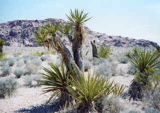
| Joshua Tree along the trail |
 |
| Moenkopi Trail to the hilltop |
At 1.5 miles, the trail intersects a medium-sized wash, a creek bed that is dry except after a rain, which is infrequent in the desert, of course. For the next 0.3 miles the trail will use the wash itself as a treadway, so expect some soft, loose gravel under your feet. The Grand Loop Trail reenters from the right, and shortly thereafter the trail exits the wash to the left.
The trail curves gradually left, now on the final gentle uphill climb back toward the Visitor Center. At 2 miles, the trail ends at the Visitor Center parking lot. While you are here, you should take time to drive the 13 mile scenic road around the canyon. The road gives a close-up view of the mountains seen in the distance along this trail and lets you see the canyon from a different perspective, thus giving a complete picture of Red Rocks.
No comments:
Post a Comment