Trails: Ghost Coon and Dripping Springs Trails
Hike Location: Natural Falls State Park
Geographic Location: west of West Siloam Springs, OK (36.17549, -94.66769)
Length: 1.4 miles
Difficulty: 5/10 (Moderate)
Date Hiked: April 2023
Overview: A loop hike, mostly easy but with a couple of steep areas, that forms the long route to Natural Falls.
Park Information: https://www.travelok.com/state-parks/natural-falls-state-park
Hike Route Map: https://www.mappedometer.com/?maproute=935410
Photo Highlight:
From the parking area, head downhill (south) through the formal garden. The plants in bloom here vary throughout the season, and some irises were in bloom when I came here in late April. At the bottom of the formal garden, the ADA-accessible trail to the top of Natural Falls continues straight. We will return on that trail, but for now turn left to walk along a park road, cross a creek on a low water ford, and look to the right for the signed start of the Ghost Coon Trail. Turn right to begin the Ghost Coon Trail, which is named after the legendary raccoon from Where the Red Fern Grows.
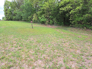
The Ghost Coon Trail heads into the woods and climbs gradually. At 0.2 miles, the trail enters a sunny grassy area with what appears to be a wastewater treatment pond on the left. At 0.3 miles, you reach the park's yurt area access road, which is actually a continuation of the road you walked on earlier. Turn left to walk a short distance on the road, then look to the right for the signed continuation of the Ghost Coon Trail.
After another short distance in the woods, the trail traces the perimeter of the large tallgrass prairie that also contains the park's yurt area. The yurts can be seen across the prairie to the right. Ignore side trails that exit left into the woods; they quickly become indiscernible.
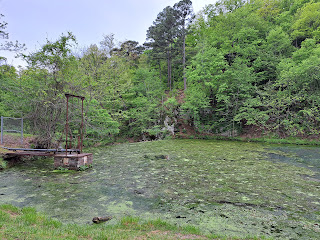
0.7 miles into the hike, you pass under a power line to reach the park's yurt area. The route through the yurt area is unmarked and confusing. You want to keep the yurts to your right until you reach a gravel road that was recently paved with fresh gravel on my visit. Turn sharply left on the gravel road and begin a steep descent to reach a dam with old rusty controls that forms a small algae-covered lake. Turn right to begin hiking along the shore of the lake, and pass through a fishing area that contains a few benches. Some scenic rocky cliffs stand on the other shore of the lake.
Now on the Dripping Springs Trail, at 0.9 miles you cross a metal bridge with wooden deck that spans the upper reaches of the small lake. Next comes the hardest part of the hike: the trail heads steeply uphill through a tight rocky gorge. Numerous roots and rocks need to be negotiated, and you have to watch your footing. A fall into the gorge to the right would likely result in serious injury. Ignore the Bear Trail, an even more treacherous trail that exits left.
1.1 miles into the hike, the difficult rocky area mercifully ends when you reach some concrete steps, which go uphill to the left and downhill to the right. Go downhill first to reach the viewing platform at the base of Natural Falls. This ledge-type waterfall features a large but shallow plunge pool, and the vertical lumpy rock walls make for an imposing setting. Notice the bridge at the top of the falls to the right and the platform at the top of the falls to the left.
Next climb all of the concrete steps to reach the ADA-accessible waterfall overlook platform, which provides a top-down view of the rocky bowl you stood in moments ago. These concrete steps are in rough shape and will need to be rebuilt at some point, but they still get the job done for now. After taking in this view, walk along the ADA-accessible path to reach the formal garden, and then walk uphill through the formal garden to return to the parking lot and complete the hike.
Hike Location: Natural Falls State Park
Geographic Location: west of West Siloam Springs, OK (36.17549, -94.66769)
Length: 1.4 miles
Difficulty: 5/10 (Moderate)
Date Hiked: April 2023
Overview: A loop hike, mostly easy but with a couple of steep areas, that forms the long route to Natural Falls.
Park Information: https://www.travelok.com/state-parks/natural-falls-state-park
Hike Route Map: https://www.mappedometer.com/?maproute=935410
Photo Highlight:
Hike Video:
Directions to the trailhead: From West Siloam Springs, take US 412 west 5.5 miles to N4680 Road and turn left on N4680 Rd. Drive N4680 Rd. south 0.2 miles to E578 Road and turn left on E578 Rd. Drive E578 Rd. east 0.1 miles to the state park entrance on the right. Turn right to enter the park, then turn left immediately after passing the park office to reach the parking area for Natural Falls.
The hike: Consisting of only 120 acres, Natural Falls State Park is one of the smallest state parks in Oklahoma. Before it became a state park, the site was privately owned and operated as a roadside attraction known as Dripping Springs. The property featured a swimming pool and gardens, and it appeared in the 1974 film Where the Red Fern Grows. The site was purchased by the State of Oklahoma for its state park system in 1990, making it Oklahoma's newest state park.
The site's centerpiece is and has always been the 77-foot waterfall, which is tied with Turner Falls in southern Oklahoma for the tallest waterfall in the state. The park today features a 46-site developed campground, several yurts, an above-average disc golf course, some picnic areas, and several short hiking trails. The route suggested here provides one of the longest possible routes to the waterfall, and it passes several other points of interest including the campground, a rocky gorge, and a small lake.
 |
| Hiking through the formal garden |
 |
| Start of Ghost Coon Trail |
 |
| Trail reenters woods |
 |
| Yurts across prairie |
 |
| Dam that forms small lake |
 |
| Natural Falls, base view |
 |
| Natural Falls, platform view |
No comments:
Post a Comment