Trails: Island Trails
Hike Location: Martin Creek Lake State Park
Geographic Location: southwest of Tatum, TX (32.27315, -94.56653)
Length: 1.2 miles
Difficulty: 1/10 (Easy)
Date Hiked: December 2021
Hike Location: Martin Creek Lake State Park
Geographic Location: southwest of Tatum, TX (32.27315, -94.56653)
Length: 1.2 miles
Difficulty: 1/10 (Easy)
Date Hiked: December 2021
Overview: A short loop around an island in Martin Creek Lake.
Park Information: https://tpwd.texas.gov/state-parks/martin-creek-lake
Hike Route Map: https://www.mappedometer.com/?maproute=895779
Photo Highlight:
Start by walking across the iron bridge with wooden deck that leads to the island. As you walk across this bridge, an ugly power plant towers to the south, but the park's boat ramps and swimming area sit to the north. When you reach the island, continue straight to walk among the island's 12 primitive campsites and begin a clockwise journey around the Island Trails' loop.
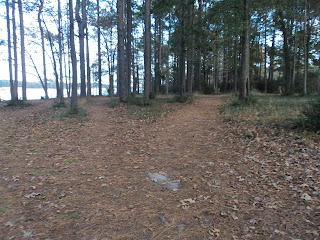
After passing through the primitive campground, the main trail curves right and climbs slightly. In general you want to choose the left fork at each trail intersection to hike the longest possible loop around the island, but occasionally this strategy will lead you down side trails that end at the lake's edge. If you accidentally or intentionally take a side trail, enjoy the lake view and then retrace your steps back to the main trail.
The island features an interesting mix of loblolly pine forest and grassy, sunny prairies. Interpretive signs identify common plants on the island. After looping around the south side of the island for another fantastic view of the ugly power plant, a final right curve brings you back to the primitive campground to close the loop. Walk back across the bridge to the mainland to complete the hike.
Park Information: https://tpwd.texas.gov/state-parks/martin-creek-lake
Hike Route Map: https://www.mappedometer.com/?maproute=895779
Photo Highlight:
Hike Video:
Directions to the trailhead: From Tatum, take SR 43 south 3.8 miles to CR 2183 and turn left on CR 2183. Drive CR 2183 0.8 miles to the signed park entrance on the right. Turn right to enter the park, pay the entrance fee, and park at the rear of the large day use parking area for the boat ramp and picnic area.
The hike: For my general comments on Martin Creek Lake State Park, see the previous hike, which explores the two trails on the north side of the park. This hike features the appropriately named Island Trails: they form a loop around a small island in Martin Creek Lake. As you would expect, the lake views are numerous and excellent, and many people think the Island Trails are this park's best hiking option.
 |
| Bridge leading to island |
|
| Park boat ramps and swimming area |
 |
| Hiking through pine forest |
 |
| Hiking through the prairie |
No comments:
Post a Comment