Hike Location: Baxter State Park
Geographic Location: northwest of Millinocket, ME (45.88171, -69.03036)
Length: 2.6 miles
Difficulty: 4/10 (Moderate)
Date Hiked: August 2019
Overview: An out-and-back to Big Niagara Falls with a view
of Mount Katahdin.
Park Information: https://baxterstatepark.org/
Hike Route Map: https://www.mappedometer.com/?maproute=760578
Photo Highlight:
Directions to the trailhead: From Millinocket, drive
Baxter Park Road 17.1 miles to the park’s Togue Pond Entrance Gate, where you
will need to pay your entrance fee ($15 for non-Maine residents on my visit) and
tell the park rangers what part of the park you wish to visit. The road surface turns to gravel at the
entrance gate. Follow the narrow and
winding Park Tote Road 10 miles to the signed turnoff for Daicey Pond. Turn left and drive the narrower Daicey Pond
driveway to the Daicey Pond day use parking area on the right. Park here.
The hike: The
words Katahdin and Baxter are legendary in hiking circles. As the northern terminus of the Appalachian
Trail (AT), northbound AT through-hikers spend months making their way over
mountain after mountain to reach the final mountain, Mount Katahdin. Katahdin is also the highest point in Maine,
and its huge multi-peaked steep-sided pinnacle dominates the landscape for
miles around. On point, the 5269 foot
mountain stands 4288 feet above its highest adjacent valley.
Katahdin remains the icon it is
today partly due to the foresight of Percival Baxter, the Governor of Maine
from 1921-1925 for whom this park is named.
Baxter set aside 30,000 acres of land for this park, and each parcel of
land he donated came with a deed of trust that gave instructions for how to
care for the land and an endowment.
Thus, although Baxter is a state park, it is operated and funded
separately from the rest of Maine’s state park system.
Baxter’s instructions were to keep
the land wild and untouched by man, and those instructions are carried out in
the park we visit today. The vast 209,644
acre park features no amenities except trails, picnic shelters, and tent campgrounds,
and all roads in the park are narrow, curvy, gravel roads. Thus, although the road distance from the
park entrance gate to this trailhead is only 10 miles, it will take about 45
minutes to drive that distance. Plan
your visit accordingly.
Options for hikers at Baxter State
Park are almost unlimited. Of course
Mount Katahdin’s summit is the dream destination, but all trails that lead to
the summit are very long and strenuous with several thousand feet of elevation
gain. For people who cannot make such a
trek, the park has numerous locations that offer postcard views of Mount
Katahdin. One of the most famous of
these views can be had at Daicey Pond (pronounced like DAY-see), and this hike
combines this postcard view with a short journey along the AT to a pair of high-volume
waterfalls.
 |
| Mt. Katahdin across Daicey Pond |
 |
| Katahdin's Baxter Peak across Daicey Pond |
Because Mount Katahdin is the center
of everybody’s attention in this area, you may as well start by getting your
postcard view. From the day use parking
area, continue walking down the campground entrance road and climb slightly to
reach Daicey Pond Campground. The pond
is located right behind the campground’s well-volumed library (yes, this
campground has an actual building full of ink-and-paper books), and Mount
Katahdin looms large across the pond.
Mount Katahdin actually has several peaks, and this view features the
southwest Abol face of Baxter Peak, the mountain’s highest point. The moment I saw Mount Katahdin across Daicey
Pond was the highlight of my summer 2019 Maine hiking trip, which included
visits to both of Maine’s top-tier hiking destinations: Baxter State Park and Acadia National Park. I
hope you enjoy this view as much as I did.
 |
| Information kiosk at AT trailhead |
 |
| Major trail intersection |
At 0.3 miles, you reach a major
signed trail intersection. The option
going straight is the Daicey Pond Nature Trail, which leads back to Daicey
Pond. Turn right to continue southbound
on the AT, following the AT’s famous white rectangular paint blazes. A gradual descent through pine and birch
trees ensues, and the smooth dirt treadway makes for easy going. At 0.75 miles, you pass an interesting pine
tree with roots stretched down over a boulder.
 |
| Tree growing over boulder |
Just shy of 1 mile, you reach the
signed spur trail to Little Niagara Falls.
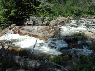
Turn right and hike the short rocky spur to the falls. While calling either of the waterfalls on this
hike Niagara requires quite a bit of embellishment, Little Niagara Falls is
more of a rocky cascade than a fall.
Nevertheless, Nesowadehunk Stream provides a lot of water to cascade,
and a large streamside boulder makes the perfect spot to catch the aquatic
action.
 |
| Little Niagara Falls |
Return to the AT and turn right to
continue southbound. The trail descends
moderately over a somewhat rocky course to reach the signed spur trail to Big
Niagara Falls. Turn right for the steep,
rocky, and rooty descent to the side of Big Niagara Falls. Though only about 20 feet high, Big Niagara
Falls is more of a true waterfall than Little Niagara Falls, and the
surrounding rocks make for a stark setting.
 |
| Big Niagara Falls |
The AT continues downstream along
Nesowadehunk Stream for several more miles, but there are no more waterfalls
nearby. Thus, most hikers turn around
here and retrace their steps to the Daicey Pond parking area. Other nice dayhikes at Baxter State Park
include a 4-mile hike along the AT to Katahdin Falls, another nice waterfall
with Katahdin-fed waters, and a 6.5 mile hike to Katahdin Lake, which features
a view of Mount Katahdin from the side opposite of Daicey Pond.
No comments:
Post a Comment