Saturday, July 20, 2024

Shakamak State Park: Trails #2 and #1 (Blog Hike #1018)

Trails: #2 and #1
Hike Location: Shakamak State Park
Geographic Location: southeast of Terre Haute, IN (39.17727, -87.24125)
Length: 4.5 miles
Difficulty: 5/10 (Moderate)
Date Hiked: May 2024
Overview: A loose loop around Lake Shakamak passing some old coal mines.
Park Information: https://www.in.gov/dnr/state-parks/parks-lakes/shakamak-state-park/
Hike Route Map: https://www.mappedometer.com/?maproute=962296
Photo Highlight:
Hike Video: (coming September 5, 2025)

Directions to the trailhead: From Terre Haute, take US 41 south 17.5 miles to SR 48 and turn left on SR 48.  Drive SR 48 east 9.5 miles to the state park entrance on the right.  Turn right to enter the park, pay the park entrance fee, then turn right and left at the first 2 intersections, respectively, to park in the large blacktop parking lot for the playground and swimming pool.  The trailhead for Trails #1 and #2 is on the right about halfway down this parking lot.

The hike: Opening in 1929, Shakamak State Park protects 1766 acres of fairly flat land 30 miles southeast of Terre Haute.  The park was developed in the 1930's by the Civilian Conservation Corps (CCC), who built many of the picnic shelters, trails, and other buildings still used today.  The park's name comes from the Delaware or Kickapoo name for the nearby Eel River, and it translates to "river of the long fish."
            The park is most famous for its 3 lakes: Lake Lenape, Lake Shakamak, and Lake Kickapoo, all of which are formed by dams on the same waterway.  Fishing is particularly good here, but the park also features a 174-site developed campground, several cabin areas, numerous picnic shelters, and 7 hiking trails totaling over 13 miles.  The route described here combines 2 of the park's most popular trails as it explores the northern section of the park, and it forms a loose loop around Lake Shakamak while also exploring this area's coal mining history.
Trailhead at large parking lot
    
        The signed trailhead for Trails #1 and #2 is 
on the north side of the large parking lot near its midpoint.  Turn right at the first intersection, then continue straight where Trail #1 turns left to cross a narrow inlet of Lake Shakamak on a wooden bridge.  These turns start you on a counterclockwise journey around Trail #2.  The large number of lotuses in this inlet would make a great flower show in late summer.
Lotus colony in Lake Shakamak
    
        Soon you cross wooden trail bridge #201, i.e. the 1st bridge on Trail #2, before climbing gradually.  The difference between maximum and minimum elevations on this hike is only about 50 feet, but the numerous small ups and downs make this hike more challenging than you might expect for this part of Indiana.  At 0.3 miles, you cross the main park road before paralleling it for several hundred feet.
Crossing a creek
    
        For the next 0.4 miles the trail parallels an unnamed creek with a steep but shallow ravine.  When you cross the creek on a wooden footbridge, look to the left for a coal mine demonstration site.  Although this demonstration mining shaft was built for the park by the CCC, before this park was established miners would crawl into shafts like this one and dig out the coal.  Numerous interpretive signs describe these old coal mines and the people who worked them.
Demonstration coal mining shaft
    
        Traffic noise from SR 48 comes within earshot from the right as the trail curves left to climb out of the first ravine and enter a second one.  The trail alternates between ravine bottom and rim, creating more down and up than you might prefer.  At 1.3 miles, you cross the park road for a second time.
Intersecting Trail #1
    
        Near 1.5 miles, you reach the end of Trail #2 at an intersection with Trail #1, which goes straight and right.  You could continue straight if you wanted a hike of only about 2 miles, but this hike turns right to do a full circumnavigation of Lake Shakamak, which reappears to your left at this point.  Some large hickory trees live near Lake Shakamak, and I did some good wildflower viewing including violets and asters when I came here in early May.
Sweet violet
    
        For the next 1.75 miles the sometimes narrow trail stays within sight of Lake Shakamak as it passes around 3 of its 4 arms.  Only minor ups and downs are encountered, and the lakeside hiking is pleasant if unremarkable.  At 3.25 miles, the trail climbs gradually away from the lake and soon crosses the cabin access road.  The terrain here is flat and the woods scenic.
Hiking along the lake
    
        At 3.6 miles, you pass a collection of picnic shelters.  If these shelters are not reserved, they make nice places to rest and have a trail snack.  At 3.8 miles, you come out at the cabin and boat ramp road, where the trail seems to end.  Turn left here, then in a few hundred feet angle right to leave the road on a gravel trail that leads to the dam that forms Lake Shakamak.
Hiking across Lake Shakamak's dam
    
        The trail surface turns to asphalt as you head east across the dam.  Lake Shakamak appears to the left, and Lake Kickapoo appears downstream to the right.  After crossing the dam, turn left to continue Trail #1; the asphalt Pedestrian Path goes straight here.  Quickly Trail #1 comes out at the west end of the large parking lot that contains your car, and a short walk across the parking lot concludes the hike.

Saturday, July 13, 2024

Spring Mill State Park: Trail #4 (Blog Hike #1017)

Trail: Trail #4
Hike Location: Spring Mill State Park
Geographic Location: east of Mitchell, IN (38.73136, -86.41836)
Length: 2.2 miles
Difficulty: 7/10 (Moderate/Difficult)
Date Hiked: May 2024
Overview: A loop hike past a pioneer village, 2 caves, a pioneer cemetery, and an old quarry.
Park Information: https://www.in.gov/dnr/state-parks/parks-lakes/spring-mill-state-park/
Hike Route Map: https://www.mappedometer.com/?maproute=962225
Photo Highlight:
Hike Video: (coming October 17, 2025)

Directions to the trailhead: From Mitchell, take SR 60 east 3 miles to the park entrance on the left.  Turn left to enter the park, pay the entrance fee, then bear left at the next intersection.  Where the road becomes one way (against you), turn right and park in the Donaldson Picnic Shelter parking lot.

The hike: Established in 1927 as Indiana's 6th state park, 1358-acre Spring Mill State Park offers a little something for everyone.  The park lies in the Mitchell karst plain, which accounts for the large number of caves in the park.  The park's most famous attraction is its boat tour at Twin Caves; visitors ride park boats across the water and into the flooded cave.  The park also contains Donaldson's Woods Nature Preserve, which protects a rare stand of virgin timber.
            In addition to the natural features, the park contains interesting human history.  A pioneer village with a large flume and grist mill depicts what life was like here in the early 1800's.  The Civilian Conservation Corps (CCC) worked to repair and reconstruct that village in the 1930's, and they built many of the park's roads, trails, and buildings as well.  In terms of more recent history, the park also contains the Grissom Memorial that honors Gus Grissom, an astronaut from nearby Mitchell who died in the Apollo 1 accident in 1967.
            To top things off, Spring Mill State Park has excellent amenities.  The park has a 188-site developed campground, hotel-style lodging at Spring Mill Inn, the usual aquatic recreation on Spring Mill Lake, several picnic shelters, and 7 hiking trails totaling over 8 miles.  All of the park's trails are worth exploring, but I only had time to hike one of them on my visit.  I chose to hike Trail #4, which passes the pioneer village, a pioneer cemetery, and 2 caves, thus sampling both this park's human history and natural scenery.
Trailhead at Donaldson Picnic Shelter parking lot
    
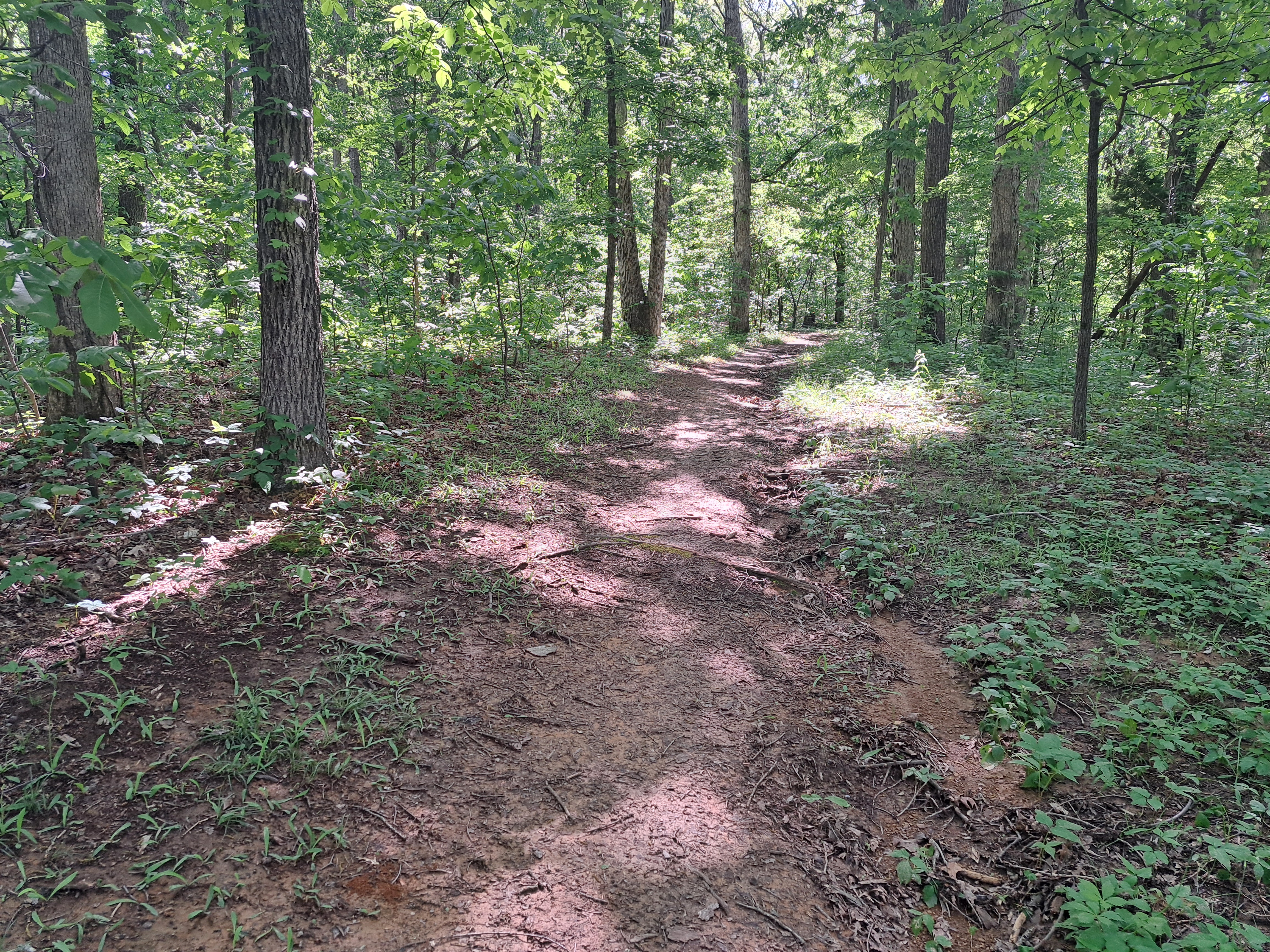
        Trail #4 is a true loop, so it leaves in 2 directions from the Donaldson Picnic Shelter parking area.  I hiked the loop clockwise by starting on the signed gravel trail heading northwest into the forest and using the trail that heads down the stairs to the east as my return route.  The fairly flat trail heads into a beautiful mature forest that is dominated by oak and hickory trees.  At 0.25 miles, you pass the Hamer Pioneer Cemetery, which has some surprisingly recent headstones among the older headstones.
Hamer Pioneer Cemetery
    
        After Trail #7 exits left, you begin the steep descent toward the pioneer village.  An interpretive sign tells you that this area used to be a quarry, and some starkly cut rocks testify to this history.  0.75 miles into the hike, you reach the bottom of the hill, the edge of the pioneer village, and a major trail intersection.  We will eventually turn right to walk through the pioneer village, but first turn left to head for Hamer Cave.
Descending into the quarry
    
        A short, steep, and slightly muddy climb brings you to the Hamer Cave overlook.  Hamer Cave is the main source of Mill Creek, and water rushes out of the cave into a pond before spilling over a dam.  A long flume diverts water to the pioneer village's mill, and the Lehigh Cement Company still diverts water from the creek for industrial cooling purposes.  Take some time to admire the odd mix of industry and natural scenery here.
Hamer Cave
Pond at Hamer Cave's mouth
    
        Next retrace your steps to the pioneer village and take a walking tour of the village.  The village's centerpiece is its huge grist mill, which was built in 1817.  Numerous smaller log buildings include a leather shop, distillery, spring house, and meeting house.  Some benches beckon you to sit, have a snack, and think about what life was like in this village 200 years ago.

Grist mill
Pioneer village
    
        Exit the village by walking northeast on a wide trail toward the main village parking area.  Where bridges take you left across Mill Creek to the parking lot, stay right to remain on the south side of the creek and continue Trail #4.  The trail stays near the creek for the next 0.6 miles, and this section of trail is rather narrow, primitive, and muddy.  On the bright side, I saw 
lots of birds in this area including goldfinches, cardinals, and robins.
Wilson Monument
    
        At 1.7 miles, Trail #1 exits left to cross the creek and head for Spring Mill Inn.  A couple hundred feet later, you reach the Wilson Monument, an odd wedge of stone placed here by former landowner George Donaldson in honor of fellow Scotsman Alexander Wilson.  Wilson is best known as the father of ornithology; he has several birds named after him.
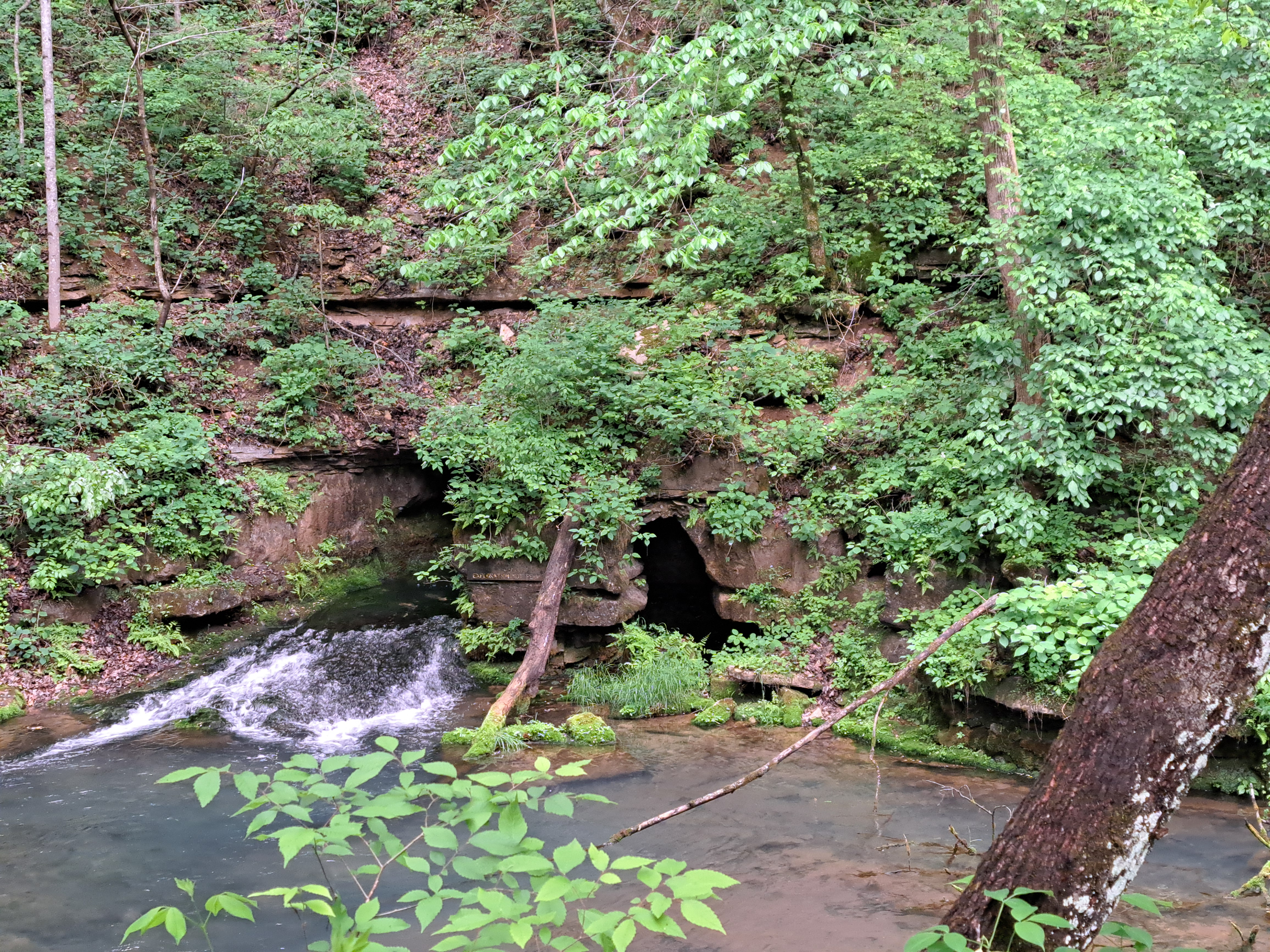
Donaldson Cave
    
        Just shy of 2 miles, you reach another trail intersection.  The wooden stairs leading uphill to the right will eventually take us back to the parking area to complete the loop, but first take the elevated walkway going straight to quickly arrive at Donaldson Cave.  The walkway actually enters Donaldson Cave, which has a much larger entrance than Hamer Cave, thus allowing you to experience the cave for yourself.  After seeing the cave, head up the 150 wooden stairs to return to the parking area and complete this hike.

Sunday, July 7, 2024

Harmonie State Park: Wabash River Picnic Area and Trail #4 (Blog Hike #1016)

Trails: #2 and #4
Hike Location: Harmonie State Park
Geographic Location: south of New Harmony, IN (38.06166, -87.96688)
Length: 3.7 miles
Difficulty: 4/10 (Moderate)
Date Hiked: May 2024
Overview: A lollipop loop starting at the Wabash River and exploring ridges and ravines.
Park Information: https://www.in.gov/dnr/state-parks/parks-lakes/harmonie-state-park/
Hike Route Map: https://www.mappedometer.com/?maproute=962146
Photo Highlight:
Hike Video:

Directions to the trailhead: In extreme southwest Indiana, take I-64 to SR 69 (exit 4).  Exit and go south on SR 69.  Drive SR 69 south 9 miles to SR 269 and turn right on SR 269.  SR 269 deadends at the park in 0.9 miles.  Pay the park entrance fee, and drive the main park road to the Wabash River Picnic Area.  Park in the gravel lot near the picnic area entrance.

The hike: Located in extreme southwest Indiana, Harmonie State Park protects 3465 acres along the east bank of the Wabash River.  The park is named for the Harmony Society, a pietistic Lutheran group that emigrated to the United States from Germany between 1803 and 1805.  Led by Johann Georg Rapp, the Harmony Society founded 3 model communities in the United States: Harmony, Pennsylvania; Ambridge, Pennsylvania; and Harmony, Indiana.  The one in Indiana was later renamed New Harmony, a name the town retains today.  Located a few miles north of the park, New Harmony has many historic buildings, and it is worth a quick detour to visit the town while driving to or from this park.
            The park's main attraction is its location right along the Wabash River, but it is not without other amenities.  The park offers a 200-site developed campground, several picnic areas, 2 horse trails totaling 7.5 miles, 2 mountain bike trails totaling 19.8 miles, and 7 hiking trails totaling 8.5 miles.  Many routes through the park's trail system are possible, but this hike features Trail #4, which is this park's longest hiking trail.  A spur trail to the Wabash River picnic area is added to the start and finish of Trail #4's loop to let you take in the riverside area too.
Start of spur trail to Trail #4
    
        From the gravel picnic area parking lot, walk out to the main park road, turn left, then look to the right for the unmarked spur trail that leads to Trails #2 and #4.  This spur trail seems to be an old two-track dirt road, and you need to walk around a wooden vehicle gate that is painted black to begin heading southeast with a creek on your left.  After only a few hundred feet, you pass an old wooden barn.  This barn testifies to this land's agricultural past, and sites like this one are somewhat common when hiking through old farm fields in this part of the country.
Old barn
    
        Turn right at the first 2 intersections to remain on the wide old road.  At 0.7 miles, you reach Trail #4, which goes straight and left.  I continued straight to remain on the old road and used the single-track trail going left as my return route, thus hiking Trail #4 counterclockwise.
Climbing on straight trail
    
        The trail heads due south on a dead straight track while climbing moderately out of a ravine.  I saw a box turtle and some lizards in this ravine, but the wide and straight trail does not make for the most inspiring hiking.  At 1.2 miles, you cross the main park road and reenter the woods on the other side.  For the next mile the trail undulates gently as it stays close to the park road, which can occasionally be heard through the trees on the left.  
Some nice tulip poplar and beech trees live on this ridge, and the hiking is pleasant if unremarkable.
Ridgetop hiking
    
        1.6 miles into the hike, you cross a park road that leads to a picnic shelter.  Ignore a mountain bike trail that crosses Trail #4 a couple of times, and also ignore Trail #1 where it exits right.  Trail #1 is a short loop that leads down to the youth tent camping area, and you could add Trail #1 to this hike if you wanted to make this hike longer.
Intersecting Trail #1
    
        At 2.2 miles, you reach a marked trail intersection where Trail #1 continues straight.  You need to turn left and re-cross the main park road to remain on Trail #4.  The final segment of Trail #4 heads out a narrow finger ridge that contains more nice forest.  When I hiked here on a warm and humid morning in early May, I shared the trail with plenty of bugs, so you need to wear good bug spray for this hike during the warm seasons.
Wabash River
    
        A brief steep descent off of the end of the finger ridge closes the loop.  Turn right once and then left twice to retrace your steps to the Wabash River picnic area to complete the hike.  Before you leave, walk through the picnic area to get a view of the Wabash River.  This point is only a few miles before the Wabash River flows into the Ohio River, so the river is wide, muddy, and plenty scenic here.


Monday, July 1, 2024

Lincoln State Park: Trails #5, #3, and #1 (Blog Hike #1015)

Trails: #5, #3, and #1
Hike Location: Lincoln State Park
Geographic Location: south of Dale, IN (38.10397, -86.99544)
Length: 3.3 miles
Difficulty: 5/10 (Moderate)
Date Hiked: May 2024
Overview: A loose loop around Lake Lincoln passing many historical sites.
Park Information: https://www.in.gov/dnr/state-parks/parks-lakes/lincoln-state-park/
Hike Route Map: https://www.mappedometer.com/?maproute=962062
Photo Highlight:
Hike Video: 

Directions to the trailheadIn southern Indiana, take I-64 to US 231 (exit 57A).  Exit and enter southbound on US 231.  Drive US 231 south 5.7 miles to SR 162.  Exit and turn right on SR 162.  Drive SR 162 west 1.2 miles to the signed state park entrance on the left; the state park entrance is opposite the entrance to Lincoln Boyhood National Memorial on the right.  Turn left to enter the park, pay the entrance fee, and drive the main park road to the large parking lot in front of the beach house and camp store.  Park here.

The hike: When most people think about Abraham Lincoln's background, they think about his birth in Kentucky or his law practice in Illinois.  Yet from 1816 until 1830, when young Abraham was between 7 and 21 years old, Lincoln and his family lived in southern Indiana.  The site of the Lincoln farm is preserved as Lincoln Boyhood National Memorial, which contains a nice museum and 2 short hiking trails.
            The National Memorial was established in 1962, but 30 years earlier in 1932 the State of Indiana established Lincoln State Park directly across SR 162 from the future Memorial.  The state park occupies the site of a former pioneer community established in 1816 called Little Pigeon Creek, and Abraham worked as a clerk in the community's general store.  Also, the park has better amenities than the memorial including fishing and boating on Lake Lincoln, a 269-site developed campground, the Lincoln Amphitheater, several cabins, and several picnic areas.
            For hikers, the state park also outshines the national memorial: it features 8 trails totaling 13.6 miles.  The hike described here combines parts of 3 trails to form a loose loop around Lake Lincoln.  While not the park's longest hike, it explores the lakeside area, the Little Pigeon Creek community site, and an old fire tower, thus exploring most of the major points of interest Lincoln State Park has to offer.
Start of Trail #5
    
        Your first task on this hike is to find the start of Trail #5.  From the big parking lot, head west on the park entrance road with the lake on your left.  Angle left to walk through the lakeside picnic area, then look to the right where gravel Trails #2 and #5 share a path that enters the woods.  A small wooden post with green numbered markers marks this trailhead.
Hiking Trail #5
    
        0.25 miles from the start, Trails #2 and #5 part ways.  Turn left to stay on Trail #5.  After crossing a park road, you reach the intersection that forms Trail #5's loop at 0.4 miles.  Turn left again to start heading clockwise around the loop.
Little Pigeon Baptist Church
    
        Trail #5's loop goes through the site of the former Little Pigeon Creek community.  Unfortunately, not much of the community remains.  The trail does pass within sight of Little Pigeon Baptist Church.  The church building is not original to the community, but it does contain a cornerstone from the original church.  Also, Sarah Lincoln Grigsby's grave, Abraham Lincoln's sister, is found in the adjacent cemetery.  The trail passes through a wetland that is the outflow of Lake Lincoln, and some wooden bridges get you over the worst of the wetness.
Bridge over wetland
    
        At 0.75 miles, you reach the Gordon Home Site and Gordon Mill Site.  Abraham Lincoln would have come here many times to mill his grain, but today all that remains are some holes in the ground that look like small cellars.  You also reach a junction with a two-track dirt service road here.  Trail #5 continues to the right, but to continue our hike around the lake, you want to turn left on the unmarked dirt service road.
Gordon Home Site
    
        The service road follows a sewer line corridor, and what it lacks in scenery it makes up for in ease.  After crossing a small creek, you reach the end of the service road at a junction with Trail #3.  Turn right on Trail #3.
Hiking the service road
    
        Trail #3 enters the southern-most part of the park as it climbs on a gradual to moderate grade.  This part of the park is called Sarah Lincoln's Woods Nature Preserve, and I did some nice wildlife viewing including some
 toads, a blue jay, and a woodpecker on the warm early summer day when I hiked here.  Some large tulip poplars grow in this area, and some benches make nice places to sit and enjoy the woods.
Hiking Trail #3
    
        After a brief walk on the ridgetop, the trail descends and curves left to enter a ravine.  At 1.9 miles, you reach the end of Trail #3 at a junction with Trail #1.  Turn right and quickly come to another intersection.  If you wanted to finish this hike as a pure lakeside hike, you could angle left and hike Trail #1 the rest of the way.  To see another historical site, turn right to follow a sign that says "Firetower."  This trail is unmarked, but some maps call it the Firetower Trail.
Old fire tower
    
        Next comes the steepest climb of the hike, but you only gain about 140 feet of elevation over the next 0.25 miles.  At 2.25 miles, you reach the top of the hill and the old fire tower.  Stairs lead to the top of the fire tower, but signs warn against climbing the tower.  Views from the top are limited by surrounding trees.
Lake Lincoln
    
        The trail continues past the tower and quickly drops back to Trail #1.  Turn right on Trail #1.  The balance of the hike is a lakeside jaunt along the shore of Lake Lincoln.  Ignore side trails that exit right, but pay attention to the lotus colony in the northeast corner of the lake: it puts on a nice flower show in late summer.  After passing the campground and the boat rental area, you return to the beach house and camp store to finish the hike.