Trail: Sugar Tree Hollow Trail (Daniel Boone National Forest Trail #407)
Hike Location: Daniel Boone National Forest, Bald Rock Picnic AreaGeographic Location: west of London, KY (37.03296, -84.22387)
Length: 1.5 miles
Difficulty: 4/10 (Moderate)
Date Hiked: June 2021
Overview: A short loop through steep ravines passing several small cascades and sandstone cliffs.
Trail Information: https://www.fs.usda.gov/recarea/dbnf/recreation/recarea/?recid=39640
Hike Route Map: https://www.mappedometer.com/?maproute=876079
Photo Highlight:
Hike Video:
Directions to the trailhead: In southern Kentucky, take I-75 to SR 192 (exit 38). Exit and go west on SR 192. Drive SR 192 west 9.6 miles to the signed Bald Rock Picnic Area on your right. Turn right to enter the picnic area, and park in the small gravel lot near the restrooms.
The hike: Often overlooked in favor of Daniel Boone National Forest's more famous nearby hiking destinations such as Natural Arch and Bee Rock, Bald Rock Picnic Area occupies the ridgetop site of the former Bald Rock Fire Tower. The tower was staffed by trained fire watchers until the 1970's, at which time fire watching from aircraft began. Today only some small pegs from the tower's foundation remain, and they are visible beside an interpretive sign in the middle of the picnic area road's small loop.
For hikers, Bald Rock Picnic Area is the jumping off point for two trails. The Cane Creek Trail leads several miles along its nearby namesake creek, and it offers both hiking and backpacking opportunities as well as backcountry fishing in Cane Creek. The only route from the picnic area to the Cane Creek Trail is the Sugar Tree Hollow Trail, the short 1.5 mile loop described here. The Sugar Tree Hollow Trail offers a sample of hiking through the rugged hollows of southern Kentucky without pegging the length or difficulty meters, and it makes a scenic but primitive after-picnic hike.
 |
| Picnic area trailhead |
 |
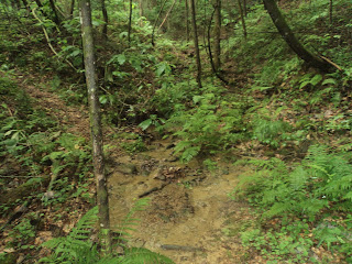
| Descending on eroded trail |
 |
| Stepping across a creek |
 |
| 2 talus boulders |
 |
| Sandstone cliffs |
No comments:
Post a Comment