Trail: Little Gap Trail
Hike Location: Dreher Island State Park
Geographic Location: southeast of Newberry, SC (34.08194, -81.40335)
Length: 2.1 miles
Difficulty: 4/10 (Easy/Moderate)
Date Hiked: January 2018
Overview: A lollipop loop with considerable up-and-down and
good views of Lake Murray.
Park Information: https://southcarolinaparks.com/dreher-island
Directions to the trailhead: There is no direct route
from the interstate to Dreher Island State Park, so follow these directions
carefully. North/west of Columbia, take
I-26 to Columbia Avenue (exit 91). Exit
and go west on Columbia Ave. Drive
Columbia Ave. 2.1 miles to the town of Chapin, where you need to turn right on
Chapin Road and then quickly turn left on St. Peters Church Road. Drive St. Peters Church Rd. 3.6 miles to
Dreher Island Road and turn left on Dreher Island Rd. Drive Dreher Island Rd. 2.9 miles to State
Park Road and turn left on State Park Rd.
State Park Rd. deadends at the park entrance in 2.6 miles. Pay the park entrance fee, then drive the
main park road past the boat ramp and Visitor Center and around the one way
picnic shelter loop to Yellow Poplar Drive on the right. Park in the parking lot that is Yellow Poplar
Dr.
The hike: Established only in 1990, Dreher Island
State Park (also known as Dreher Island State Recreation Area) protects 348
acres on three islands in Lake Murray.
The man-made lake, created by the Saluda Dam located 11 miles east of
here as the crow flies (or as the fish swims), predates the park by more than
60 years. Built to provide hydroelectric
power for South Carolina, Lake Murray was the largest man-made lake in the
world at the time it was built.
The park
has many amenities including a 97-site developed campground, 5 lakeside villas,
10 picnic shelters, and 3 boat ramps.
For hikers, the park offers 3 trails, but two of them are less than 0.5
miles long. The exception is the 2.1
mile Little Gap Trail described here. A
lollipop loop with a long stick, the Little Gap Trail traverses rolling wooded
terrain as it offers nice views of Lake Murray.
 |
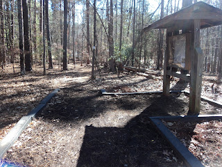
| Information kiosk at trailhead |
The trail
starts at an information kiosk at the southeast side of the parking lot. Lots of white plastic diamonds with black
arrows mark the way, and the trail had recently been cleared of leaf litter on
my visit. After a brief stint in the
forest, the trail crosses the main park road via a marked crosswalk and enters
a small pine planting.
In less
than 500 feet, the spur trail to the Red Maple Drive picnic shelters exits
left. Stay right to descend slightly and
cross a small stream on a wooden footbridge.
At 0.3 miles, you dip through a shallow but very steep ravine before
starting a long gradual climb. Although
the difference between maximum and minimum elevations is only 60 feet, the
Little Gap Trail has very few flat sections.
 |
| White granite in trail |
0.5 miles
into the hike, you reach the hike’s highest elevation as you round a small
knob. Many chunks of white granite
buried in the trail here make the treadway quite rough. A gradual to moderate descent comes next as
the trail passes under a low voltage power line. Some partially obstructed views of Lake
Murray can be had during the leafless season, but the best lake view is still
to come.
At 0.8
miles, the trail forks to form its short loop.
As directed by several black arrows, I turned right and used the trail
going straight as my return route, thus hiking the loop counterclockwise. Some minor ups and downs bring you to the
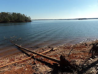
bench and lake view that is the highlight of this hike. Although a few luxury lakeside homes can be
seen from this southeast-facing viewpoint, the view is surprisingly natural
given its location less than 25 miles from Columbia. Also, I was surprised by the clarity of the
lake’s waters. The view can be
enchanting, but be careful how close you get to the edge: the bank you are
standing on has been undercut by the lake’s many years of lapping water.
 |
| Lake Murray viewpoint |
Past the
viewpoint, the trail brushes the power line clearing as it passes over the
southern-most knob. At 1.2 miles, you
close the loop. Continue straight and
retrace your steps to the parking lot to return to your car and complete the
hike.
No comments:
Post a Comment