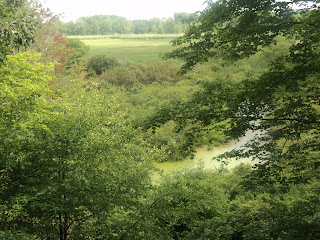
Trail: Big Loop Trail
Hike Location: Bay City
State
Geographic Location: north of Bay City ,
MI (43.67519, -83.92265)
Length: 2.8 miles
Difficulty: 2/10 (Easy)
Date Hiked: August 2017
Overview: A loop hike through a large wetland along Lake
Huron .
Area Information: https://www.michigan.gov/recsearch/parks/baycity
Directions to the trailhead: Just north of Bay
City , take I-75 to Wilder Road/SR 13 (exit 164). Exit and go north on SR 13. Drive SR 13 north 3.5 miles to Beaver
Road ; there is a traffic light at this
intersection. Turn right on Beaver
Rd. Drive Beaver
Rd. east 2 miles to SR 247 and turn left on SR
247. Drive SR 247 north 0.2 miles to Killarney
Beach Road and turn softly left on Killarney
Beach Rd. Drive
Killarney Beach Rd. north 0.5 miles to the signed
entrance for Tobico Marsh on the left.
Turn left to enter the marsh, and drive the bumpy gravel entrance road
0.3 miles to its end at the marsh’s only parking lot.
The hike: Located just north of its namesake city,
Bay City State Recreation Area consists of 2100 acres along Saginaw
Bay
While many
state recreation areas only provide recreation, Bay City State Recreation Area
also preserves an ecologically valuable wetland. The area’s Tobico Marsh comprises 1652 acres
of wetlands including a wide expanse of open water, thus making it one of the
largest freshwater coastal wetlands in the Great Lakes
region. The wetland came under state
ownership in 1957 when Frank Anderson donated the land to the State of Michigan
to form Tobico State Wildlife Refuge. In
1976, the wetland was designated a National Natural Landmark, and in 1995 the
wildlife refuge merged with adjacent Bay City
State Park
The area
features 7 miles of trails open to hikers.
The area’s most popular trail is the paved 2.5 mile Anderson
Nature Trail, which is also part of the 17.5 mile Bay County
Riverwalk/Railtrail. For hikers wanting
to get off the pavement and away from zooming bikes, the best option is the 2.8
mile Big Loop Trail described here. This
route takes you through the dryer part of the wetland and past two observation
towers that provide nice views out into the wetland’s open waters. As you would expect for a wetland, bugs are
bad during the summer, so wear plenty of good bug spray.
 |
| Trailhead: Big Loop Trail |
Three
trails depart from the information board at the rear of the parking area. The trail going left will be our return
route, and the wide trail going straight offers a shortcut that by-passes the first
observation tower. This hike starts with
the trail on the right, which is marked with a brown sign that says “Start of Big
Loop Trail, Observation Towers
As usual in
Michigan state recreation areas,
trail intersections are numbered and have trail maps posted. The trailhead is intersection #19, and this hike’s
initial segment takes you to intersection #18.
The winding sandy dirt trail uses wooden bridges to cross some narrow
wet depressions. In extremely flat areas
such as Tobico Marsh, a couple feet of elevation change means the difference
between being wet most of the year and dry most of the year.
 |
| Bridge over wet area |
Just shy of
0.3 miles, you reach the first of two observation towers. These towers stand 3 stories above the
ground, but they are located a couple hundred feet from the water’s edge. Thus, you will need to bring binoculars if
you want to do some good bird viewing across the open water. A stash of canoes also sat at this tower on
my visit.
 |
| View from first tower |
The first
observation tower is also trail intersection #18. Taking the paved trail that heads east leads
to some more platforms located closer to the open water, but the Big Loop Trail
heads west to quickly reach trail intersection #20. Turn right at trail intersection #20 to
continue the Big Loop Trail.
 |
| Hiking the Big Loop Trail |
The wide
sandy dirt trail heads northwest parallel to the open water, which remains out
of sight to your right. 1 mile into the
hike, you reach the second observation tower, which in terms of construction is
a carbon copy of the first one. Fewer
trees surround this tower, but you will still need binoculars to see any birds
in the open water.
 |
| View from second tower |
Past the
second tower, the trail continues north through more of the same scenery. At 1.4 miles, you reach the northern-most
point on this hike as the trail makes a sweeping left turn to begin heading
southeast. Some of the trees back here
have large burls growing in them.
The balance
of the hike is a dead flat southeast ramble with a slightly lower wet area on
your left and a field across the recreation area’s boundary on your right. Some nearby thunder hurried my steps, but the
heavy part of the thunderstorm stayed north of me even as some raindrops pelted
my hat. A left curve and final wooden
bridge return you to the parking lot to complete the hike.
No comments:
Post a Comment