Trails: (unnamed)
Hike Location: Pioneers
Park Nature Center
Geographic Location: west side of Lincoln ,
NE (40.77445, -96.77537)
Length: 1.9 miles
Difficulty: 2/10 (Easy)
Date Hiked: June 2016
Overview: A loop hike through various kinds of prairie
wetlands.
Park Information: https://www.lincoln.ne.gov/City/Departments/Parks-and-Recreation/Parks-Facilities/Pioneers-Park-Nature-Center
Directions to the trailhead: On the west side of Lincoln ,
take US 73 to Van
Dorn Avenue .
Exit and go west on Van Dorn Ave. Drive Van Dorn Ave.
west 1.6 miles to the main entrance for Pioneers
Park Nature
Center Nature
Center
The hike: Established in 1963, 950 acre Pioneers
Park
Fortunately
for hikers, Pioneers Park Pioneers
Park Nature Center
 |
| Trail entrance gate |
From the
parking area, cross the entrance road and enter the Nature
Center 5pm on my
visit) and make sure you plan to be out well before then. Our tour through the trail system turns left
on the mulch trail reached immediately after walking through the gate. You may want to check out the exhibits and
pick up a trail map in the Chet Ager
Building
The mulch
trail heads east before making a sweeping 180-degree right turn around a demonstration
beehive. Soon the first of many seasonal
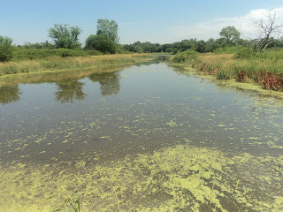
wetlands appears on the left. The trail
map calls this area the Wood Duck Wetlands, but the frogs greatly outnumbered
the ducks on the hot early afternoon of my visit. All of the ponds at Pioneers
Park
 |
| Wood Duck Wetlands |
At 0.2
miles, you reach a trail intersection located directly in front of the Chet
Ager Building
After
crossing a wooden footbridge over a small channel that connects the two
wetlands, you reach another trail intersection.
Angle left here to begin walking an old road and head for Fleming Woods,
this hike’s next destination. The trail
soon jogs right to leave the old road and pass through another gate in another
chain link fence. This gate marks your
entrance to Fleming Woods, and it too has a posted scheduled closing time.
 |
| Hiking through Fleming Woods |
Fleming Woods is a fairly small
grove dominated by oak trees, and a double loop takes you through the
area. This double loop used to be a
triple loop, but part of the last loop got washed out by a Haines Branch Creek
flood a few years ago. Thus, if you
accidentally start the third loop, which is easy to do because none of the
trails are signed or marked, you will have to backtrack to continue the second
loop.
0.6 miles
into the hike, a short narrow spur trail to Owl Point exits left. Owl Point forms a wide 180-degree bend in
Haines Branch Creek, and a staircase gives access to the stream. Contrary to what you might expect this far
from the sea, the water in Haines Branch Creek is slightly salty due to this
area’s large salt deposits. The steps to
the creek were very overgrown with grass when I came here, and the overall
level of maintenance throughout the trail system was adequate but less than
ideal.
 |
| Haines Branch Creek |
After
closing the Fleming Woods loop and walking back out the chain link fence gate,
angle left at the next few trail intersections.
At 0.9 miles, you reach the north end of a suspension bridge over Haines
Branch Creek. Consisting of a wooden
deck strung from steel cables, this suspension bridge is the park’s only route
across the creek. Over 3 miles of trails
lie south of the creek, and you should feel free to cross the bridge and hike
them if they are open on your visit, which they were not on mine. Thus, I had to continue straight to stay on
the north side of the creek. The trail
map calls this trail the Animal Trail though no signs on the ground indicate
such.
At 1.05
miles, you enter the sunny prairie just before reaching a signed trail
intersection. The trail going straight
provides the shortest route back to the parking area, but I suggest turning
left to hike a loop through the lowland prairie. The wide dirt/grass trail heads west with the
Muskrat Wetland, which is constantly visible on the right. I saw more birds and another heron in this
seasonal wetland.
 |
| Muskrat Wetland |
As you
approach the park’s western boundary, the trail curves right to cross a pair of
boardwalks over wet areas. The park’s
bison pasture appears over a fence to the left, but I saw no bison on my hike. After tracing along the north side of the
Muskrat Wetland, you reach the end of the lowland prairie loop, where a left
turn is required to continue this hike.
The trail
joins an old gravel road as it passes a small aviary on the right. The aviary features hawks, owls, eagles, and
turkeys, and the birds in these cages are here because they have sustained
injury and could not survive in the wild.
Just before reaching the park road, the trail curves right to head
through a narrow strip of woods with the paved road on the left and the Heron
Wetlands on the right. Heading east
parallel to the park road, you pass some flower beds to reach the main trail
entrance gate, where a left turn exits the natural area and returns you to the
parking lot.
No comments:
Post a Comment