Trail: Caney Fork Creek Nature Trail
Hike Location: Chester State
Park
Geographic Location: southwest of Chester , SC (34.67729, -81.24016)
Length: 2.6 miles
Difficulty: 2/10 (Easy)
Date Hiked: September 2013
Overview: A mostly flat out-and-back along the north shore
of Park Lake
Park Information: https://southcarolinaparks.com/chester
Directions to the
trailhead: From the junction of SR 72 and US 321 southwest of Chester ,
drive SR 72 west 1.5 miles to the signed park entrance on the left. Turn left to enter the park. Bear left to pass the entrance house, paying
the small entrance fee, and stay on the main road to arrive at the grassy
ballfield where it forks to form a circle.
Angle right to head counterclockwise around the circle, and look for a
small red sign that says “nature trail and boathouse” with an arrow that points
right down a gravel road. Turn right
down this gravel road, and park in the small gravel parking lot near the
boathouse. There is room for 5-7 cars
down here.
The hike: The tall, stately pines that line the park entrance
road give away this land’s long history as parkland. Purchased from the Lake View Corporation in
1935, the depression-era Civilian Conservation Corps (CCC) did the hard work to
turn this land into the park we see today. Chester
is a small town, but the park’s central location halfway between Columbia
and Charlotte make this park a
popular location for reunions and gatherings.
Though only
523 acres in size, the park has a wealth of recreation opportunities. The park’s 160-acre lake and adjacent boat
house provide good fishing and boating. Chester
State Park
 |
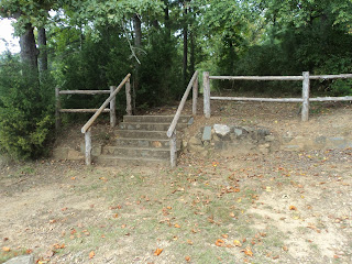
| Concrete steps at trailhead |
The trail
starts by climbing 6 concrete stairs with a wooden handrail at the far end of
the boat house. For the entire outbound
distance the park lake remains on the left, often in view. At 0.1 miles, the trail descends 8 stone
steps without a handrail. These stone
steps are probably the work of the CCC.
After
treading around the first of three inlets, you reach a picnic area at 0.25
miles. The first half of this trail
passes through the park’s developed area, so the sounds of activity will be
nearby in season. A clearing just
downhill from the picnic shelter gives a nice view across the tranquil lake.
 |
| Wide grassy trail |
The trail
reenters the forest on a grassy track and treads around the second inlet to skirt
the park’s campground at 0.6 miles. A
creaky wooden pier provides more nice lake views down the length of the lake.
Past the campground, the trail leaves the developed area of the park, allowing
more quiet and solitude to be had.
 |
| Tranquil Park Lake |
After
passing around the last inlet, the trail moves slightly away from the lake and
assumes an elevation about 8 feet above lake level. Pine needles offer a cushy trail surface
here. At 1.3 miles, you come out at the
spillway for the dam that forms Park Lake
 |
| Spillway at dam |
No comments:
Post a Comment