Trails: River, Canyon View, County
Line Lake
View Lake
Shore
Hike Location: Pipestem
Resort State Park
Geographic Location: northeast of Princeton , WV (37.54051, -80.98327)
Length: 7.2 miles
Difficulty: 8/10 (Moderate/Difficult)
Date Hiked: June 2014
Overview: A grand tour of Pipestem
Resort State Park Indian Branch
Falls
Park Information: https://wvstateparks.com/park/pipestem-resort-state-park/
Directions to the trailhead: From I-77, take exit 14
and follow signs to SR 20. Turn left on
SR 20 and drive 9.3 miles north on SR 20 to the park entrance. Turn left to enter the park. Drive the main park road 3.2 miles to the
gravel parking area for the Arboretum on the right. Park here.
If you reach the T-intersection for the lodge and the golf course, you
have driven 0.2 miles too far.
The hike: For my general comments on Pipestem
Resort State Park
 |
| River Trail trailhead |
Your
journey begins on the River Trail, which departs from a signed trailhead across
the main park road from the arboretum.
Walk around a brown vehicle gate and begin a moderate descent on a wide
two-track dirt trail. The trail loses over
200 feet of elevation in the first 0.3 miles as you descend to reach a wide
shelf in the Bluestone River Bluestone River
Where the
two-track switches back to the right at the bottom of the hill, continue
straight to stay on the orange-blazed River Trail. For the next mile the trail undulates slightly
as it heads southwest with the outer gorge wall nearby on your left. The park’s second-growth broadleaf forest
consists mostly of oak, maple, and tulip poplar trees. At 1.3 miles, you reach a junction with the
Canyon Rim Trail. We will continue
straight on the River Trail later, but to get a view of the inner gorge, turn
right here for a 0.3 mile side trip to Heritage Point.
 |
| Junction with Canyon Rim Trail |
 |
| View from Heritage Point |
Retrace
your steps back uphill to the River Trail and turn right to continue your
southward journey. 2.1 miles into the
hike, you pass under the famous aerial tramway.
Few people ever see the tram from this angle, another distinctive
feature of this hike.
 |
| Looking up at the tramway |
The trail
treads around a couple of shallow ravines, after which the gorge shelf on which
you are traveling widens. At 2.7 miles,
you reach the junction with the County Line Trail. Turn left to begin your journey out of the
gorge on the County Line Trail. This
trail gets its name from the fact that it crosses into adjacent Mercer
County Summers
County
The next
0.9 miles are an easy cruise on what appears to be an old roadbed. The trail follows the contour of the land as
it heads into the broad and deep ravine of Indian Branch, which falls away to
your right. At 3.6 miles, you reach the
short spur trail to Indian Branch
Falls
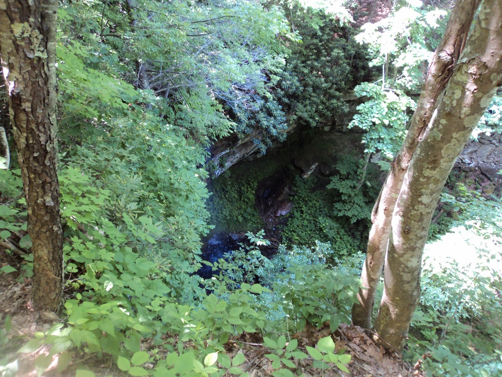 |
| Indian Branch Falls |
Just past
the waterfall, the County Line Trail turns left to leave the old road just
before you reach a metal vehicle gate.
You may hear vehicles on the gravel road beyond this gate. The next mile is the most difficult part of
the hike, so now is the time to get your mojo on. The trail climbs and descends a couple of low,
steep arms that jut out from the main ridge, which rises to the left. The ravine gets shallower as you continue
along the left (south) side of the ravine.
 |
| Climbing on the County Line Trail |
At 4.4 miles,
you start the steepest part of the climb.
The creek that has been hiding in the ravine to the right now merges
with the trail, forming a deep rut down the middle of the trail. After a pair of switchbacks, you reach the
rim of the ravine and a junction with one of the park’s horse trails. Turn left to reach an intersection with the
Dogwood Trail (described elsewhere in this blog), then turn right to reach the Nature
Center Nature
Center 12:30 to 4:30 . I got lucky and arrived here just as the
center opened. Also, the drinking
fountain in the Nature Center
The next
leg of this hike is the Lake View Trail.
To get there, walk out the Nature
Center Nature Center
 |
| East-facing park road overlook |
 |
| Lake View Trail trailhead |
The Lake
View Trail descends on another old road with a grassy area visible through the
trees to your right. Unlike some of the
park’s other trails, this trail shows signs of heavy horse use. 5.3 miles into the hike, the Lake View Trail
turns left to leave the old road. There
is a sign at this turn, but it is not in an obvious place. I made the mistake of staying on the old
road, which I followed for another 0.5 miles downhill to a vehicle gate at the
park boundary. I then paid for my
mistake by retracing my steps 0.5 miles back uphill to this intersection.
About 600
feet later, the trail forks with the signed horse trail taking the higher line
to the left and the signed hiking/skiing trail taking the lower line to the
right. Of course, you should choose the
option going right. Although the park
has designated this trail as hiker-only, I could tell that a large number of
horses still find their way onto this trail.
 |
| Intersection with Lake Shore Trail |
 |
| Hiking the Lake Shore Trail |
The wide blue-blazed dirt trail
undulates gently as it dips in and out of ravines. Ironically given its name, the Lake Shore
Trail on this side of the lake always stays at least 30 feet above lake level. The lake can be seen only through the trees
during the leafy months.
6.3 miles
into the hike, the trail curves right and climbs moderately but only for a
short distance to tread around a particularly large ravine. The trail maintains this higher elevation as
the concrete dam that forms Long Branch
Lake
 |
| Intersecting the Den Tree Trail |
After
wading through some tall grass, you enter the forest and cross Long Branch
Creek on a small wooden footbridge. As
hard as it may be to believe, this small stream is indeed the outflow of Long
Branch Lake
 |
| Crossing the Law Hollow Trail |
After passing under the power line,
the trail seems to end as the blacktop trail to the boat rental area comes into
view on the left. Make your way down to
the paved trail using whatever route seems most feasible, then continue
climbing gradually on the paved trail.
Where the paved trail curves right, turn right on a grassy trail to
climb a little more, soon reaching the arboretum. A left turn and short walk across the
mown-grass of the arboretum will return you to the arboretum parking lot and
complete the hike.
No comments:
Post a Comment