Trails: Black Rock Lake and Edmonds Backcountry Trails
Hike Location: Black Rock Mountain State Park
Geographic Location: north of Clayton, GA (34.92348, -83.40913)
Length: 1.8 miles
Difficulty: 3/10 (Easy/Moderate)
Date Hiked: September 2022
Overview: A flat loop around Black Rock Lake followed by a moderate out-and-back to Greasy Creek Falls.
Park Information: https://gastateparks.org/BlackRockMountain
Hike Route Map: https://www.mappedometer.com/?maproute=921520
Photo Highlight: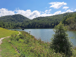
The trail starts at the rear of the parking area; an information kiosk and sign mark the trailhead. The entrance trail descends over some wooden waterbars to reach an intersection with the Lake Trail after only about one hundred feet. Angle right to begin a counterclockwise journey around Black Rock Lake.
Marked with blue plastic diamonds, the Lake Trail quickly reaches a wooden platform with a couple of picnic tables. This platform gives a fantastic southward view across the lake with Black Rock Mountain in the background. Due to a nearby wide spot in Taylor Chapel Road, most people choose to park and start their hike here rather than at the official trailhead, which is the one at the start of this trail description.
Past the platform, a short boardwalk brings you to the dam area, which offers a nice eastward view across the length of Black Rock Lake. Next the trail curves left to begin its journey up the lake's more secluded south bank. I did some nice wildlife viewing here that included some turtles, a pair of white ducks, some Canada geese, and even some fish in the rather clear lake water. Some wet areas need to be negotiated, but the park has dumped some gravel to mitigate the wettest areas. Numerous iron benches provide opportunities to sit, rest, and observe the lake.
Immediately after crossing Taylor Creek on a footbridge at 0.75 miles, you reach a trail intersection. The Lake Trail continues to the left, and we will go that way to complete this hike eventually. To also hike to Greasy Creek Falls, turn right on a narrow connector trail that is marked with white plastic diamonds. After paralleling Taylor Creek for only a couple hundred feet, the connector trail ends at the Edmonds Backcountry Trail, which is marked with orange plastic diamonds. Turn right to head south on the Edmonds Trail.
The Edmonds Trail re-crosses Taylor Creek on another footbridge and begins climbing. For the most part the grade to Greasy Creek Falls is gradual, but some areas with exposed roots will need to be negotiated. Large amounts of rhododendron grow in the understory, giving this forest a crowded, damp feel.
At 1.2 miles, you cross Greasy Creek on a wooden footbridge and reach the base of Greasy Creek Falls. A 20-foot sliding-water cascade, Greasy Creek Falls will not make anyone's list of world's greatest waterfalls, but it provides a nice add-on to a hike around Black Rock Lake. The Edmonds Trail continues for several miles past the waterfall, but it soon gets very steep, and there are no further points of interest in close proximity. Thus, I chose to turn around and retrace my steps to the Lake Trail, where a right turn quickly closes the loop around Black Rock Lake. Another right turn and short walk up the entrance trail return you to the trailhead to complete the hike.
Hike Location: Black Rock Mountain State Park
Geographic Location: north of Clayton, GA (34.92348, -83.40913)
Length: 1.8 miles
Difficulty: 3/10 (Easy/Moderate)
Date Hiked: September 2022
Overview: A flat loop around Black Rock Lake followed by a moderate out-and-back to Greasy Creek Falls.
Park Information: https://gastateparks.org/BlackRockMountain
Hike Route Map: https://www.mappedometer.com/?maproute=921520
Photo Highlight:

Hike Video:
Directions to the trailhead: From the park's Visitor Center, drive back out the entrance road 2 miles to its intersection with Taylor Chapel Road. Turn left on Taylor Chapel Rd. Drive gravel Taylor Chapel Rd. 0.7 miles downhill to the trailhead parking area for the Black Rock Lake Trail on the left. Turn softly left and drive down the short but steep hill to the parking area; park here.
The hike: For my introduction to Black Rock Mountain State Park, see my hike on this park's Tennessee Rock Trail, which is its most famous trail. Although this park is most famous for being the highest state park in Georgia, even the lower elevations of Black Rock Mountain offer interesting sites to see. Never coming within 1200 vertical feet of the mountain's summit, this hike starts with a circumnavigation of scenic Black Rock Lake on its namesake trail. The lake loop is followed by an out-and-back on the Edmonds Trail to Greasy Creek Falls, which is a "hidden" waterfall in the sense that it does not appear on the park map. Thus, this hike explores all of the best sites the lower elevations of Black Rock Mountain have to offer.
 |
| Trailhead for Black Rock Lake Trail |
 |
| Black Rock Mountain behind Black Rock Lake |
|
| Black Rock Lake, dam area |
 |
| Canada geese near Black Rock Lake |
 |
| Climbing on the Edmonds Trail |
 |
| Greasy Creek Falls |


