Showing posts with label North Dakota Hikes. Show all posts

Wednesday, September 5, 2018

Cross Ranch State Park: Matah and Cottonwood Trails (Blog Hike #713)

Trails: Matah and Cottonwood Trails
Hike Location: Cross Ranch State Park
Geographic Location: south of Washburn, ND (47.21352, -100.99974)
Length: 5.7 miles
Difficulty: 4/10 (Moderate)
Date Hiked: August 2018
Overview: A somewhat long but flat double loop featuring views of the Missouri River.
Hike Route Map: http://www.mappedometer.com/?maproute=706699
Photo Highlight:

Directions to the trailhead: Just west of Bismarck, take I-94 to SR 25 (exit 147).  Exit and go north on SR 25.  Drive SR 25 north for 18.7 miles to 28th Avenue SW.  Turn right on 28th Ave. SW.  Drive 28th Ave. SW 5 miles to 16th Street SW and turn right on 16th St. SW.  Drive 16th St. SW 4.4 miles to its end and turn left.  The park entrance is 2 miles ahead on your right.  Turn right to enter the park, drive under the railroad underpass, and park in the gravel Visitor Center parking lot, making sure to pay the entrance fee before you begin the hike.

The hike: Located on the west bank of the Missouri River about 20 miles upstream from Bismarck, Cross Ranch State Park and adjacent Cross Ranch Nature Preserve protect 5589 acres along the last free-flowing stretch of the Missouri River.  The land’s ranch days started in 1879 when A.D. Gaines, a land agent for the Northern Pacific Railroad, purchased 11,000 acres that included this site.  The ranch used the Maltese cross brand on its livestock, and when the ranch’s title transferred to Bob and Gladys Levis in 1956, the ranch was renamed Cross Ranch.  The Nature Conservancy purchased the ranch in 1980, and both the Nature Conservancy and Burlington Northern Railroad donated land to create the state park.
            Before Gaines ever came to this area, the Lewis and Clark Expedition camped across the river from this park in October 1804, and they made their winter camp that year just a few miles upstream from here.  A Lewis and Clark campsite marker is located in the park’s southern section near the Sanger boat launch.  In terms of amenities, the park has both a developed and primitive campground, log cabins and yurts, picnic shelters, and a boat ramp.  For the hiker, the park offers over 16 miles of trails with the best ones going along the Missouri River.  This hike takes you along the river but also explores an old growth cottonwood grove, thus providing a sample of all the hiking the park has to offer.
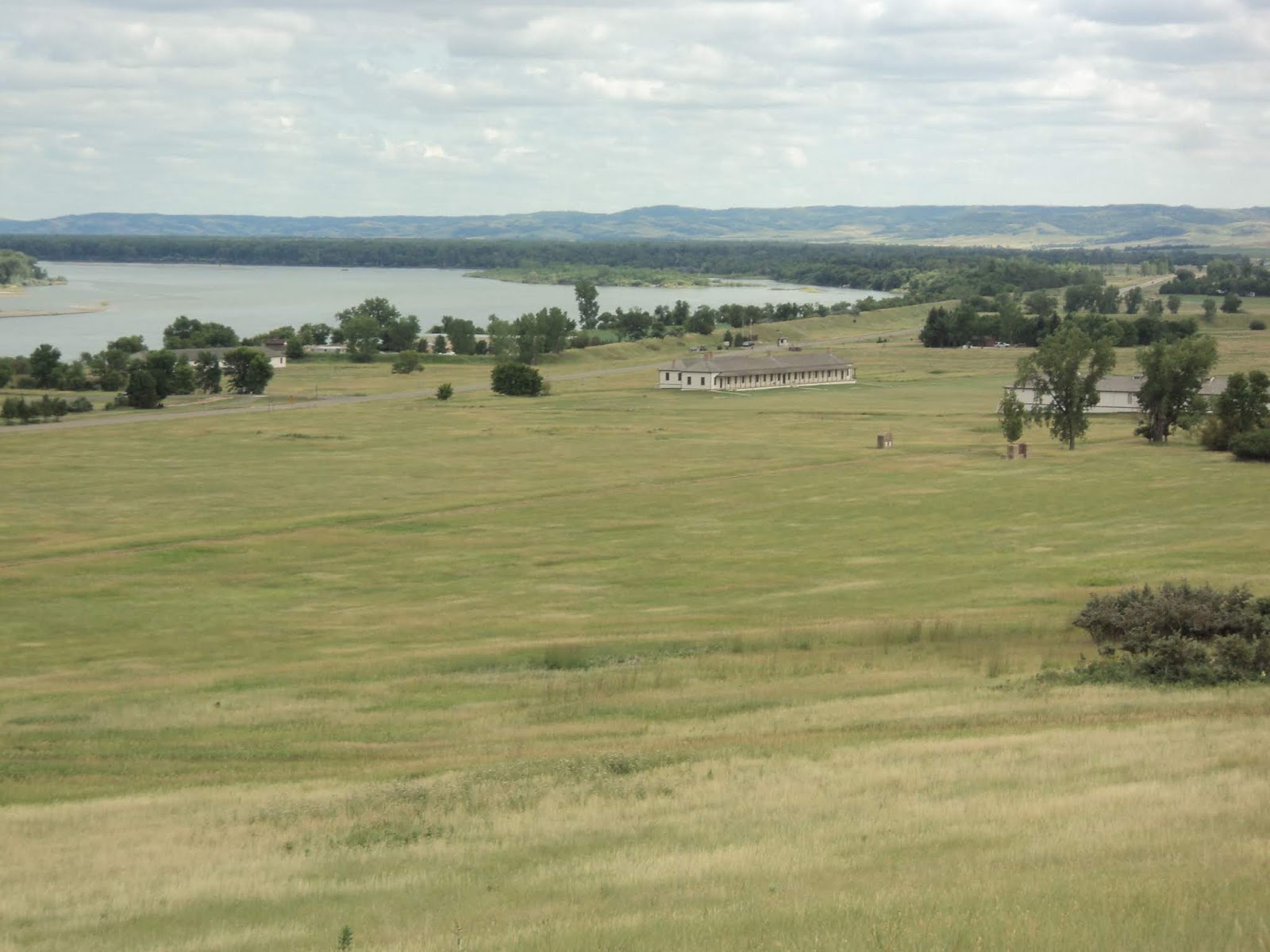
Heading south from the Visitor Center
            From the Visitor Center, head south on a concrete sidewalk that passes through a mowed-grass area to reach the park’s amphitheater.  Brown carsonite posts bearing the letters MT indicate that you are on the Matah Trail.  Past the amphitheater, the trail’s surface turns to dirt as the wide trail continues its southbound course.  Numbered posts suggest the presence of an interpretive guide, but none were available in the Visitor Center.
            At 0.3 miles, you reach this hike’s southernmost point at a signed trail intersection.  The trail going straight leads further south to the park’s Sanger section, but that trail was flooded by the Missouri River on my visit.  Thus, I turned left to continue the Matah Trail.  The Missouri River soon comes into view on the right, and for the next 0.9 miles the trail heads northeast parallel to the river.
Missouri River, looking downstream
            The section along the Missouri River is by far my favorite part of this hike.  The river was wide, swift, and muddy on my visit, and ripples in the water betray logs and other obstructions lurking under the water.  Signs warn you to stay away from the river’s eroding banks: undercut banks can collapse sending you tumbling into the water with disastrous consequences.  Benches placed near the river invite you to stop and enjoy the riparian scenery.
Bench along Missouri River
            While the river stays close on the right, the park’s primitive campground and yurt area stay close on the left.  In general you want to ignore spur trails that exit left, but some hand pump water wells in the campground are the only potable water source on this hike.  At 1.2 miles, the trail exits the park’s developed area as it angles left to leave the riverbank.  One of the river’s overflow channels now separates you from the river’s main course.  While these channels are dry most of the year, they store enough standing water to make bugs a real issue on the rest of this hike.
            1.5 miles into the hike, you reach another signed trail intersection where the Cottonwood Trail exits right.  We will continue the Matah Trail’s loop later, but to increase the distance and explore the old growth cottonwood grove, turn right to begin the Cottonwood Trail.  Immediately the Cottonwood Trail passes through a gate in a wire fence and splits to form its loop.  For no reason, I stayed straight and used the trail going left as my return route, thus hiking the Cottonwood Trail counterclockwise.
Hiking through the cottonwoods
            The grassy two-track Cottonwood Trail heads in the general direction of north as it enters the cottonwood grove.  The hike through the seemingly endless cottonwoods may seem boring to some people, but the trees are tall and stately, and the flat terrain makes for easy going.  At 2.8 miles, you exit the cottonwoods to begin hiking along the edge of a grassy field.  The Missouri River lies out of sight across the field to the right.
            Just past 3 miles into the hike, the east end of the Gaines Trail exits right.  Named for the previous landowners, the 2.1 mile Gaines Trail loop gives access to the 2.2 mile Levis Trail loop, and you could add one or both of them if you have the time and energy to extend the hike.  This description angles left to follow the brown carsonite posts bearing the letter C for the Cottonwood Trail.
Carsonite post along Cottonwood Trail
            At 3.2 miles, you reach the other (west) end of the Gaines Trail.  Turn left to begin the west arm of the Cottonwood Trail.  This part of the forest has a dense grassy understory, and soon the trail curves right to dip through another river overflow channel.  For the next 1.2 miles the Cottonwood Trail parallels this channel with the sunny, grassy channel on the left.
River overflow channel
            4.8 miles into the hike, the Cottonwood Trail curves left, crosses the channel, and returns to its southern end and its intersection with the Matah Trail.  Walk back through the gate in the wire fence and turn right to continue the Matah Trail.  Now back in the cottonwood grove, the trail curves left to keep heading in the general direction of south.  The farm fields beyond the park’s west boundary come into view through the trees to the right.
Back on the Matah Trail
            Just past 5.5 miles, you cross a gravel park road just before you cross a small gully on a wooden footbridge.  The last few hundred feet parallel this gully with the gully on the left.  Soon the Visitor Center comes into view ahead and to the right, thus marking the end of the hike.

Monday, September 3, 2018

Theodore Roosevelt National Park: Painted Canyon Nature Trail (Blog Hike #712)

Trail: Painted Canyon Nature Trail
Hike Location: Theodore Roosevelt National Park
Geographic Location: east of Medora, ND (46.89434, -103.38265)
Length: 0.9 miles
Difficulty: 3/10 (Easy/Moderate)
Date Hiked: August 2018
Overview: A short lollipop loop with some steep areas offering up-close views of badlands rock formations.
Hike Route Map: https://www.mappedometer.com/?maproute=735096
Photo Highlight:

Directions to the trailhead: This hike starts at the west end of the I-94, exit 32 rest area in western North Dakota.  This rest area is accessible to both eastbound and westbound traffic.

The hike: After I hiked at Grand Bay in Mississippi and Fanny Bay in Florida, both of which start at rest areas on I-10, I thought I had done every hike that starts at an interstate rest area.  Then as I was driving I-94 across North Dakota to/from Montana, I stopped at the rest area at mile marker 32 to stretch my legs and found this hike.  Much to my surprise, this rest area also contains an official Visitor Center for Theodore Roosevelt National Park, which sits immediately north of the interstate.  Thus, this hike is not only a rest area hike but also a national park hike.
            Established in 1978, Theodore Roosevelt National Park is the only national park to be named after an individual.  The 26th President’s dedication to conservation is honored at this park because he spent several years hunting bison here in the late 1800’s.  The park consists of two sections, a northern section and a southern section, and both sections offer scenic, rugged badlands scenery.  The park’s southern section is the one bordering I-94.
This short hike takes you deep into a badlands canyon, thus letting you see the badlands’ colored rocks and interesting rock formations up close and personal.  Despite the short length, do not underestimate the difficulty of this hike.  The trail includes some short steep sections, and almost the entire hike is exposed to the sun, making for hot hiking in the summer.  Also, do not attempt this hike after a heavy rain: water turns the badlands’ dirt into thick, goopy mud.
Painted Canyon Nature Trail trailhead
Start at the signed trailhead for the Painted Canyon Nature Trail on the west side of the rest area.  Do not confuse this trail with the similarly named but much longer Painted Canyon Trail that starts on the east side of the rest area.  The narrow trail immediately leaves the canyon rim and begins descending on a moderate to steep grade that features some wooden waterbars.  Views of the colorful rock bands that give this canyon its name open up to the left.
Descending on Painted Canyon Nature Trail
At 0.15 miles, the trail splits to form its loop.  I chose to continue straight and use the trail going right as my return route, thus hiking the loop clockwise.  The trail is marked only by some brown carsonite posts bearing the words “Painted Canyon,” but the route is easy to follow for the most part.  Small clusters of ponderosa pine trees border the trail, and large amounts of goldenrod line the sunny areas.
After more descending, you reach the lowest elevation of the hike at 0.4 miles.  This point sits roughly 250 vertical feet below the canyon rim, and looking around reveals both the colorful cliffs above you and the grassy canyon bottom below you.  A bench placed here invites you to sit and see what you can see provided it is not too hot.
Colorful butte in Painted Canyon

Rock bands in Painted Canyon
The trail curves right and starts ascending around a tall banded rock formation that stands to the right.  A colorful red/orange butte stands ahead in the distance.  Moderate ascending brings you to the close of the loop.  A soft left turn and more climbing return you to the rest area to complete the hike.  Before you leave, check out the exhibits about Badlands flora and fauna in the national park Visitor Center located at this rest area.

Saturday, August 18, 2018

Fort Abraham Lincoln State Park: Young Hawk and Little Soldier Loops (Blog Hike #703)

Trails: Young Hawk and Little Soldier Loops
Hike Location: Fort Abraham Lincoln State Park
Geographic Location: south of Mandan, ND (46.76526, -100.84591)
Length: 3.2 miles
Difficulty: 4/10 (Moderate)
Date Hiked: July 2018
Overview: A lollipop loop featuring the site of a former infantry post.
Hike Route Map: http://www.mappedometer.com/?maproute=704556
Photo Highlight:

Directions to the trailhead: On the west bank of the Missouri River, take I-94 to Mandan Avenue (exit 153).  Exit and go south on Mandan Ave.  Drive Mandan Ave. south 0.6 miles to Main Street and turn right on Main St.  Drive Main St. west 0.3 miles to SR 1806 and turn left on SR 1806.  Drive SR 1806 south 7 miles to the signed park entrance on the left.  Turn left to enter the park, pay the park entrance fee, and park in the blacktop lot in front of the Visitor Center.

The hike: The year was 1872 when companies B and C from the United States’ 6th Infantry built an infantry post along the future route of the Northern Pacific Railroad near where it would cross the Missouri River in North Dakota.  The post was originally called Fort McKeen, but less than six months after its construction the name was changed to Fort Abraham Lincoln to honor the recently assassinated President.  Soon a cavalry post was added, and about 650 men were stationed at the fort, which consisted of 78 separate buildings.  The fort’s first commander was Lt. Col. George Custer, who used the fort as a base during the American Indian Wars including the Battle of Little Bighorn, where Custer was famously killed.
            As the Indian Wars subsided, the fort lost its importance, and it was abandoned in 1891.  The fort’s site was deeded to the State of North Dakota by President Theodore Roosevelt in 1907, and starting in 1934 the Civilian Conservation Corps (CCC) began building park infrastructure on the site.  Today Fort Abraham Lincoln State Park is one of the best state parks in North Dakota.  In addition to the historic sites, the park offers a 114-site campground, 2 cabins, and 2 tipis for lodging.
            In terms of trails, the park contains 7 miles of trails most of which are open to hikers, mountain bikers, and horses.  All of the lodging and historic sites are accessible by trail, though some of them are hard to incorporate into a single nice loop.  The lollipop loop described here takes you through the site of the infantry post while offering a tour of the park’s more remote areas and excellent views from some of the park’s highest land.  Note that most of this hike is exposed to the sun, so wear sun protection and drink plenty of water during the warmer months.
Trailhead at Visitor Center parking lot
            Start on the asphalt bike trail that departs the southwest corner of the Visitor Center parking lot.  The trail crosses the main park road, curves right, and begins to climb.  Although the trail is paved, this initial segment is actually the steepest climb of the hike.  Ignore an old road that exits left through a vehicle gate and heads toward the cavalry post.
            At 0.2 miles, you reach the signed start of the Interpretive Trail (also signed as the Scout Trail), which exits left.  Turn sharply left to leave the asphalt and begin the dirt Interpretive Trail.  The climb continues but on a more gradual grade as the trail works its way around the hill on which the infantry post stands.
Cavalry post and Missouri River
Views of the cavalry post and the Missouri River to the south get better the more you climb; the breeze may intensify as well.  The treadway on this part of the hike was somewhat narrow and rutted, but the route was easy to follow on my visit.  Numbered carsonite posts suggest the existence of an interpretive guide though none were available at the trailhead.
Climbing toward the infantry post
            At 0.7 miles, you reach a trail intersection near carsonite post #13 where you need to turn sharply right to remain on the Interpretive Trail; the option going straight leads to a cemetery and deeper into the trail system.  The trail next crosses the steep asphalt road that gives vehicles access to the infantry post, and soon the infantry post’s reconstructed blockhouses come into view.  Walk up to the southern-most of the three blockhouses and climb the steep ladder to its top for a 360-degree view.  These blockhouses were rebuilt by the CCC in 1935, and they provide great views from the highest point on this hike.
Approaching the first blockhouse
            After climbing the first blockhouse, take the concrete sidewalk-like trail to the northeast that heads to the next blockhouse.  The former sites of some other buildings are signed, and in some cases remnants of the foundations are visible.  At 1.2 miles, you reach the second blockhouse and the northern end of the infantry post site.  Take the grass/dirt trail to the right of the blockhouse to continue north, exit the infantry post site, and re-enter the park’s natural area.
Site of former infantry post structure
            Now on the Little Soldier Loop, the sidehill trail descends gradually with the top of the finger ridge on the right and a ravine falling to the left.  Prairie plants dominate the northern part of the park, and some bright red honeysuckle berries brightened my path on the seasonally cool July evening that I hiked here.  Mountain bikes also traverse this part of the trail system, so step off the trail and let them pass if people riding bikes approach.
            Just past 1.5 miles, you reach a trail intersection where you need to angle right to remain on the Little Soldier Loop.  Now approaching the park’s northern boundary, the trail makes a sweeping 180-degree right turn around the north end of the finger ridge.  A nice view of the North Dakota State Capitol and downtown Bismarck over the Missouri River emerges to the northeast.
View northeast toward Bismarck
            Now heading south, a gradual climb precedes a gradual descent as the Heart and Missouri Rivers appear below you ahead and to the left.  Near 2.5 miles, you enter a grove of cottonwood trees that constitutes the only wooded portion of this hike.  The asphalt Mandan-Fort Lincoln Bike Trail can be seen downhill to the left.
Hiking through the cottonwood grove
            At 2.8 miles, the Little Soldier Loop ends where you reach a stone CCC-built picnic shelter with a nearby vault toilet and drinking fountain.  Angle left to walk out toward the main park road, then turn right on the asphalt bike path.  Walking along the bike path for 0.3 miles returns you to the Visitor Center parking lot to complete the hike.
            Before you leave the park, there are at least two other places you should visit.  Located behind the Visitor Center, the On-A-Slant Village recreates a Mandan Indian village that was inhabited on this site between the late 1500’s and the late 1700’s.  The village gives a nice flavor of what life was like here during the pre-fort days.  Also, while this hike explored the infantry post, the cavalry post is located near the park entrance; it features Lt. Col. George Custer’s house among other structures.  The park offers daily tours of both of these historic places, so get the most out of your park entrance fee by seeing all the historic sites the park has to offer before leaving.