Saturday, June 29, 2013

Tugaloo State Park (Blog Hike #414)

Trail: Sassafras Circle Trail
Hike Location: Tugaloo State Park
Geographic Location: northeast of LavoniaGA (34.49755, -83.07653)
Length: 3.6 miles
Difficulty: 4/10 (Moderate)
Dates Hiked: February 2013, January 2023
Overview: An interesting frontcountry hike with good lake views and wildlife viewing.
Photo Highlight:
Hike Video: 

Directions to the trailhead: In northeast Georgia, take I-85 to SR 17 (exit 173).  Exit and enter north on SR 17.  In less than 0.2 miles, turn right on Gerrard Road, cross the railroad tracks, then immediately turn right to continue on Gerrard Rd.  Drive Gerrard Rd. its entire length to SR 328 and turn left on SR 328.  Drive SR 328 3.3 miles to the park entrance road on the right.  Turn right on Tugaloo Park Road, enter the park, and park in the blacktop old boat ramp parking lot behind the Visitors Center.

The hike: Formed by the confluence of the Tallulah and Chattooga Rivers some 20 miles northwest of here, the Tugaloo River used to flow southeast as it forms the border between Georgia and South Carolina.  The word “Tugaloo” comes from the Cherokee Indian name for this particular river.  The river’s days of flowing ended with the construction of Hartwell Dam in the 1950’s, and today Tugaloo State Park occupies a hilly peninsula that juts eastward into Lake Hartwell.
            The most popular activities at Tugaloo State Park center around the lake.  The park features a white sand beach area, a 6-lane boat ramp, 20 lakefront cottages, and 105 campsites.  Hikers have two trails to choose from: the 3.6 mile blue-blazed Sassafras Circle Trail and the 0.75 mile red-blazed Muscadine Trail.  This description will focus on the more substantial Sassafras Circle Trail.  Truth be told, 0.3 miles of the Muscadine Trail are also used on the Sassafras Circle Trail, so you could easily hike both in a single journey by making only a short detour.
            The Sassafras Circle Trail starts at a brown carsonite post to the right of the old boat ramp parking area downhill from the Visitors Center.  Information on the post gives the average hiking time as 4 hours, but I completed this loop is roughly half that time.  The trail heads through the grassy picnic area with the lake in full view on your left.  Some southern-style swings provide opportunities to sit and admire the water.           
Trail enters woods
            At the far end of the grassy area, a blue carsonite post marks where the trail enters the woods.  At 0.2 miles, the trail splits to form its loop.  I chose to turn left here and hike the loop clockwise.
            After crossing a small stream, the trail traces around a wide sunny peninsula that appears to contain a canoe launch area.  Notice the cut made into the hillside to create a level trail surface here and think of the labor it took to build this trail.  If rain has fallen recently, look for animal tracks in the soft disturbed soil underfoot.  On my visit I saw several sets of deer tracks in this area, and later in the hike I saw a group of white-tailed deer.
            After passing some wooden steps that exit right up to an old parking area, you enter a confusing area where the blue carsonite posts are needed to keep you on the trail.  The entire Sassafras Circle Trail is well-marked with blue paint blazes and blue carsonite posts, without which parts of this trail would become a real exercise in route-finding.
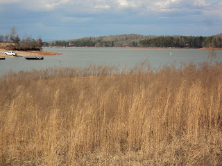
Lake Hartwell
            Now back in the woods, the trail briefly follows a wide old dirt road before crossing another creek on a wooden footbridge and climbing moderately.  1 mile into the hike, you cross the paved north cottage area entrance road.  With the north cottage area to your left, the trail tops a surprisingly steep hill before dropping to cross the paved north cottage area exit road. 
            The trail drops through two steep ravines, and in between it rises to cross a narrow paved boat ramp access road.  At 1.5 miles, you pass a bench that offers a nice view of Lake Hartwell through the trees.  On my visit, two anglers on a boat a few yards from me were trying their luck in the water.  Also, in this area the Sassafras Circle Trail starts following the much older Crow Tree Nature Trail, as indicated by a wooden sign.  Notice that the trail here is much more worn and easily distinguished from the surrounding ground compared to some sections of trail you hiked earlier.
Wooden footbridge
            1.7 miles into the hike, you reach the campground amphitheater.  Instead of taking the main lighted path to the right out of the amphitheater, stay with the blue blazes as the trail curves right and climbs slightly to reach a blue carsonite post at the shoulder of the northern campground road.  The trail’s designated route from this point is not clear, but the best option is to turn right and walk along the northern campground road back to the main park road.  Ignore a blue blaze to the left of the campground road near the Nature Hut.
            Upon reaching the main park road, cross the road and walk downhill through a grassy area to reach the southern campground loop.  Turn right on this loop, walk up to the next intersection, and then angle left as the trail reenters the woods.  Another blue carsonite post and a blue paint blaze mark this point.
Trail exits campground
            Leaving the campground behind, the trail dips through a steep but shallow ravine and begins a moderate climb toward the highest point on this hike.  An old trail bridge indicates that this section of trail has been rerouted in the recent past.  After crossing the access road for the south cottage area, the trail continues to climb and, 2.4 miles into the hike, reaches an intersection with the red-blazed Muscadine Trail, which goes straight and right.  The two options come back together in 0.3 miles on the right option and 0.4 miles on the straight option, so you could go either way here.  Being the purist that I am, I chose to turn right here to stay with the blue blazes of the Sassafras Circle Trail.
            The trail stays on the high ground for a short distance with some white silos to your right before curving left and descending moderately.  At 2.7 miles, the two arms of the Muscadine Trail come back together.  The Sassafras Circle Trail turns right here while the Muscadine Trail continues straight.  Again, follow the blue blazes to stay on the right trail.           
Intersecting the Muscadine Trail
            The trail descends to cross the beach access road and the beach access trail in quick order before turning right and climbing steeply for a short period of time.  A double blue blaze marks this turn.  After dropping to cross the paved road to the group picnic shelter, the trail crosses a creek on another wooden bridge and ascends again with the primitive camping area on your left.  A new road was being built here on my visit, and this section of trail may be the faintest on the entire loop.
            3.3 miles into the hike, the trail comes out at the primitive campground access road.  You need to turn right here and walk along the seldom-used primitive campground access road back out to the main park road, but there are no trail markings here to indicate such.  Upon reaching the main park road, cross it and reenter the woods where you will once again find the blue blazes.  After a short downhill stint, you close the loop.  A left turn and 0.2 miles of retracing your steps will return you to the Visitors Center and complete the hike.

Hickory Knob State Park: Beaver Run Trail (Blog Hike #413)

Trail: Beaver Run Trail
Hike Location: Hickory Knob State Resort Park
Geographic Location: west of McCormickSC (33.87910, -82.43121)
Length: 2.2 miles ONE WAY
Difficulty: 3/10 (Easy/Moderate)
Date Hiked: February 2013
Overview: An out-and-back featuring the historic Guillebeau House.
Hike Route Map: http://www.mappedometer.com/?maproute=154039
Photo Highlight:

Directions to the trailhead: From McCormick, drive west on US 378 5.8 miles to CR 7 and turn right on CR 7.  Take CR 7 1.6 miles to the signed state park entrance on the left.  Turn left to enter the park, then drive 3.8 miles to the park lodge.  Park in the parking lot beside the lodge.  The trail starts across the road from the parking lot.

The hike: For my general comments on Hickory Knob State Resort Park, see the Turkey Ridge Loop blog entry.  The Beaver Run Trail may be my least favorite trail at Hickory Knob State Park because 1) it stays close to the developed park area for its entire length and 2) it does not form a loop.  In spite of these shortcomings, this trail still offers a pleasant hike through the woods and decent views of Strom Thurmond Lake.  I came here on a chilly early February morning and did not pass another person along the entire trail.
            Before beginning, I need to make a quick note about the length of this trail.  The park lists the length at 2.5 miles.  However, my measurements indicate that this trail is only 2.2 miles, so I have listed it that way here.  I completed this hike as an out-and-back in just over 2 hours.
Trailhead-Beaver Run Trail
            The south end of the trail begins at a wooden information kiosk across the road from the park lodge.  The single track dirt trail heads slightly downhill with the lake visible through the trees to your left and the park road occasionally audible uphill to your right.  The trail is marked with white paint blazes and also white metal diamonds with the words “Beaver Run Trail” printed in green on them.  The forest is typical Piedmont forest with maple, sweet gum, slash pine, and loblolly pine.  The southern pine beetle has ravaged some other parts of this park’s forest.  This area features a few fallen pine trees with signs of beetle damage, but it has held up better than most.
Trail markers near Guillebeau House
            The trail passes a residence uphill and to the right.  A trio of fenced-in dogs noisily greeted me as I walked along the trail downhill from their home.  At 0.4 miles, the trail curves left and traces three sides of the historic Guillebeau House.  The Guillebeau House is a log cabin built in 1770 as part of a Huguenot settlement a few miles north of here.  The cabin was moved to this site in 1983, and you can only see it by hiking this trail or by driving a gravel road that departs the main park road near the boat ramp.
            Past the cabin, the trail descends gradually on broad switchbacks to approach lake level.  One of the best views of the lake can be had through some young pine trees at the bottom of these switchbacks.  Now heading due north, you soon come to the 1 mile marker.
Partial view of Strom Thurmond Reservoir
            Just past the 1 mile marker, you cross an old dirt road and enter a section of forest that appears to have sustained significant storm damage a few years ago.  Dead trees lie oriented in every direction, but they do not bear the tell-tale holes of beetle damage.  Areas such as this are notoriously hard to navigate, but there are sufficient blazes to allow you to stay on the trail at all times.
Storm damaged area
            At 1.2 miles, the trail begins treading atop what appears to be a dike that prevents the lake waters on your left from flooding the park road through the trees on your right.  At the end of the dike, the trail begins following an old road as it ascends gradually.  1.4 miles into the hike, the trail leaves the old dirt road just before it reaches a maintenance area for the golf course.  More metal diamonds and a wooden barrier mark this turn.
Trail follows dike
            The final 0.8 miles take you back down to the lakeshore one more time before climbing back toward the park road using a pair of broad switchbacks.  This last climb features the steepest grade on this trail, but you will hardly work up a sweat.  At 2.2 miles, the trail comes out at the dirt parking area that serves as the overflow parking lot for the golf course and the parking lot for the skeet shooting range.  If your group brought 2 cars, you could leave one here as a car shuttle and one in the lodge parking lot where you began.  Otherwise, you will need to retrace your steps the entire 2.2 miles to complete the hike or walk back along the park road, thus reducing the return distance to about 1.5 miles but also reducing the scenery.